 view gallery view gallery SW27 km SW27 km
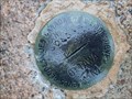
|   90L548 - Québec, Canada 90L548 - Québec, Canada
in Canadian Benchmarks Canada geotic survey posted by:  gemeloj gemeloj location: Québec, Canada date approved: 10/20/2021 last visited: never |
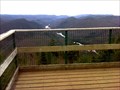
 view gallery view gallery NE36 km NE36 km
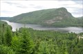
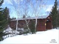
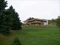
|  Belvédère du lac Ha! Ha! - Ferland-et-Boilleau, QC Belvédère du lac Ha! Ha! - Ferland-et-Boilleau, QC
in Scenic Roadside Look-Outs A spectacular view of Lake Ha! Ha! and Mont Dufour from road 381 belvedere. posted by:  denben denben location: Québec, Canada date approved: 09/22/2012 last visited: 10/02/2012 |
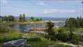
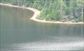 view gallery view galleryNE36 km |  Lac Ha! Ha! - Ferland-et-Boilleau, QC Lac Ha! Ha! - Ferland-et-Boilleau, QC
in Natural Lakes Lac Ha! Ha! from road 381 belvedere in Ferland-et-Boilleau. posted by: denben location: Québec, Canada date approved: 09/22/2012 last visited: 09/22/2017 |
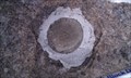 view gallery view gallery E38.1 km E38.1 km
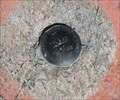
| 80k035 Mont Dufour in Canadian Benchmarks Point géodésique (Benchmark) du Ministère des Terres et Forêts du Québec. posted by: DomTrek location: Québec, Canada date approved: 04/08/2011 last visited: never |
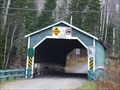 view gallery view galleryNE40.9 km |  Pont du Lac Ha! Ha! Pont du Lac Ha! Ha!
in Covered Bridges Numéro : 61-14-03 posted by: VE2LHP location: Québec, Canada date approved: 03/06/2011 last visited: 07/24/2016 |
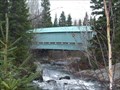 view gallery view galleryNE40.9 km | ") Pont du Lac Ha! Ha! Pont du Lac Ha! Ha!
in Histoire du Quebec (Quebec Historical Markers) Numéro / number : 61-17-04
Pont couvert à la Halte de Fernand et Boileau./
located at rest area of Fernand et Boileau. posted by: VE2LHP location: Québec, Canada date approved: 03/08/2011 last visited: 07/24/2016 |
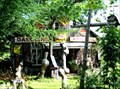 view gallery view galleryE43 km |  Pop Art on Road 381 - Saint-Urbain, Québec Pop Art on Road 381 - Saint-Urbain, Québec
in Junk Design Houses Jean-Claude Bradet colorful workshop in Saint-Urbain, Québec. posted by: denben location: Québec, Canada date approved: 08/12/2012 last visited: 10/24/2016 |
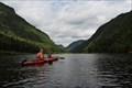 view gallery view galleryE47.5 km |  Canoe/Kayak Trip - Hautes-Gorges-de-la-Rivière-Malbaie, Québec Canoe/Kayak Trip - Hautes-Gorges-de-la-Rivière-Malbaie, Québec
in Canoe/Kayak Trips Hautes-Gorges-de-la-Rivière-Malbaie is a spectacular park that offers canoeing and kayaking down low and hiking up high. Hautes-Gorges-de-la-Rivière-Malbaie est un parc spectaculaire qui offre canoë-kayak et la randonnée vers le bas bas en haut. posted by: Trail Blaisers location: Québec, Canada date approved: 12/01/2013 last visited: 09/09/2017 |
 view gallery view gallery SE49.9 km SE49.9 km
| Pont couvert St-Placide, Charlevoix, QC in Covered Bridges Numéro : 61-14-03 posted by: VE2LHP location: Québec, Canada date approved: 03/06/2011 last visited: 11/26/2015 |
 view gallery view gallerySE49.9 km | Pont couvert de Saint-Placide-de-Charlevoix in Histoire du Quebec (Quebec Historical Markers) Numéro / number : 61-14-03
Ce pont couvert est le seul de la région de la Capitale Nationale / This bridge is the only one of the Capitale Nationale region. posted by: VE2LHP location: Québec, Canada date approved: 03/08/2011 last visited: 11/26/2015 |
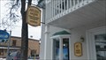 view gallery view gallerySE53.3 km |  Atelier Pierre-Gilles Martin Carole Tanguay - Baie Saint-Paul, Québec, Canada Atelier Pierre-Gilles Martin Carole Tanguay - Baie Saint-Paul, Québec, Canada
in Art Studios Atelier Pierre-Gilles Martin Carole Tanguay is located in Baie Saint-Paul, Québec, Canada. posted by: tatie location: Québec, Canada date approved: 03/19/2014 last visited: 10/09/2019 |
 view gallery view gallerySE53.6 km | Les quatres saisons (Four Seasons) in Murals Une magnifique murale représentant les quatre saisons de la région pittoresque de Charlevoix, Québec --- A beautiful mural depicting the four seasons of the picturesque region of Charlevoix, Québec. posted by: Mr. Speedy location: Québec, Canada date approved: 08/17/2005 last visited: 09/16/2019 |
 view gallery view gallerySE53.6 km |  Réserve mondiale de la biosphère de Charlevoix - Charlevoix, Québec, Canada Réserve mondiale de la biosphère de Charlevoix - Charlevoix, Québec, Canada
in UNESCO Geoparks and Biosphere Reserves La Biosphère, créée en 1988, couvre tout le territoire de l'astroblème de Charlevoix.
//
This Biosphere, designated in 1988, covers the whole territory of Charlevoix astrobleme. posted by: machard location: Québec, Canada date approved: 04/22/2018 last visited: 11/13/2021 |
 view gallery view gallerySE53.6 km |  Halte Routière de Baie-St-Paul Halte Routière de Baie-St-Paul
in Highway Rest Areas Une magnifique halte située sur la Route 138, à l'entrée de Baie-St-Paul. posted by: poildecarot location: Québec, Canada date approved: 08/23/2012 last visited: 09/21/2019 |
 view gallery view galleryE54.1 km | 77L262 - Saint-Hilarion, Québec in Canadian Benchmarks un repère géodesique situé sur un affleurement de gneiss à St-Hilarion, Québec, Canada - a benchmark located on a gneiss outcrop in St.Hilarion, Quebec, Canada posted by: oiseau_ca location: Québec, Canada date approved: 08/19/2016 last visited: 07/20/2017 |
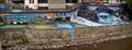
 view gallery view gallerySE61.5 km |  St-Joseph-de-la-Rive Shipyard National Historic Site of Canada, Quebec St-Joseph-de-la-Rive Shipyard National Historic Site of Canada, Quebec
in Canadian National Historic Sites The shipyard at St-Joseph-de-la-Rive in Charlevoix, Quebec is a witness to the storied history of maritime navigation and shipbuilding along the St Lawrence River in the glory days of sailed and motorized schooners. posted by: colincan location: Québec, Canada date approved: 08/14/2011 last visited: 11/10/2021 |
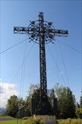 view gallery view galleryE62 km |  Croix de Clermont - Clermont, Québec Croix de Clermont - Clermont, Québec
in Christian Crosses Look at this cross from below or follow the road up the mountain and the beautiful 360 degree view. Regardez cette croix ci-dessous ou suivez la route jusqu'à la montagne et la belle vue à 360 degrés. posted by: Trail Blaisers location: Québec, Canada date approved: 11/11/2013 last visited: 02/25/2020 |
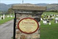 view gallery view gallerySE63.2 km |  Cimetière Notre-Dame des Eboulements - Les Eboulements, Québec Cimetière Notre-Dame des Eboulements - Les Eboulements, Québec
in Churchyard Cemeteries [EN] In 1804 construction of a new church at the top of the hills facing west and development of a new cemetery.
[FR] En 1804 construction d'une nouvelle église en haut des côtes face à l'ouest et aménagement d'un nouveau cimetière. posted by: pmaupin location: Québec, Canada date approved: 12/06/2023 last visited: never |
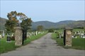 view gallery view gallerySE63.2 km |  Cimetière Notre-Dame des Eboulements - Les Eboulements, Québec Cimetière Notre-Dame des Eboulements - Les Eboulements, Québec
in Worldwide Cemeteries [EN] In 1804 construction of a new church at the top of the hills facing west and development of a new cemetery. [FR] En 1804 construction d'une nouvelle église en haut des côtes face à l'ouest et aménagement d'un nouveau cimetière. posted by: pmaupin location: Québec, Canada date approved: 02/26/2024 last visited: never |
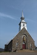 view gallery view gallerySE63.2 km |  Église L’Assomption-de-la- Sainte-Vierge - Les Éboulements, Québec Église L’Assomption-de-la- Sainte-Vierge - Les Éboulements, Québec
in Roman Catholic Churches [EN] The current church, with a strong rural character, dates back to 1932.
[FR] L'église actuelle, à caractère fortement champêtre, remonte à 1932. posted by: pmaupin location: Québec, Canada date approved: 11/19/2023 last visited: never |
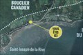 view gallery view gallerySE63.2 km |  Vous Êtes Ici : Rue Antoine Félix Savard - Les Eboulements, Québec Vous Êtes Ici : Rue Antoine Félix Savard - Les Eboulements, Québec
in 'You Are Here' Maps [EN] You are here in Saint-Joseph-de-la-Rive, sector of the municipality of Eboulements.
[FR] Vous êtes ici à Saint-Joseph-de-la-Rive, secteur de la municipalité des Eboulements. posted by: pmaupin location: Québec, Canada date approved: 11/19/2023 last visited: never |
 view gallery view gallery S64.1 km S64.1 km
|  Belvédère du sentier Les Loups - Parc national de la Jacques-Cartier, QC Belvédère du sentier Les Loups - Parc national de la Jacques-Cartier, QC
in Scenic Overlooks Belvédère d'observation situé sur le sentier Les Loups au Parc national de la Jacques-Cartier. posted by: MaitreJack location: Québec, Canada date approved: 10/26/2014 last visited: 08/17/2015 |
 view gallery view galleryE64.2 km |  Alexis le Trotteur Alexis le Trotteur
in Statues of Historic Figures C'est au parc municipal de Clermont que vous verrez un monument érigé en l'honneur d'une célébrité québécoise: Alexis Lapointe, dit Le Trotteur.
You will find this monument within Clermont's municipality park. posted by: Danatisy location: Québec, Canada date approved: 03/20/2011 last visited: 02/08/2018 |
 view gallery view gallery N64.7 km N64.7 km
| 90L-091. Chemin du Portage des Roches SUD in Canadian Benchmarks Ce repère géodésique se trouve sur la rive ouest du barrage du portage des roches à Laterrière Qc
This waymarks is on west side of Portage-des-Roches's dam in Laterrière QC posted by: DramisCram&Cie location: Québec, Canada date approved: 04/14/2009 last visited: 12/14/2012 |
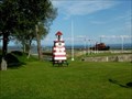
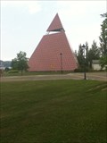 view gallery view galleryN66.1 km |  Pyramide des Ha! Ha! / Pyramid of the Ha Ha Pyramide des Ha! Ha! / Pyramid of the Ha Ha
in Pyramids La Pyramide des Ha! Ha! est un monument commémorant le Déluge du Saguenay de 1996, The Pyramid of the Ha Ha is a monument commemorating the 1996 Saguenay floods. posted by: Sires4 location: Québec, Canada date approved: 07/22/2012 last visited: 11/23/2017 |
|