 view gallery view gallery NE3.7 km NE3.7 km
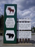
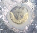
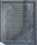
|   Watershed Boundary Sign Watershed Boundary Sign
in Elevation Signs At 395M, this location marks the boundary between the Arctic and Atlantic Watersheds posted by:  northernpenguin northernpenguin location: Ontario, Canada date approved: 07/29/2010 last visited: 08/24/2020 |
 view gallery view gallery SE15.8 km SE15.8 km
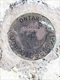
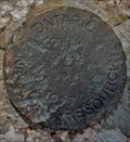
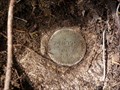
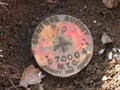
|  00820150656 Disk - Hwy 144, ON 00820150656 Disk - Hwy 144, ON
in Canadian Benchmarks Bronze MTO survey disk mounted on rock face posted by:  13acres 13acres location: Ontario, Canada date approved: 07/17/2019 last visited: never |
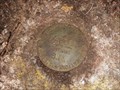
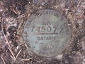
 view gallery view galleryNE26.6 km | 36U2321 - Gogama, ON in Canadian Benchmarks A bronze disk stamped 36U2321 mounted in a rock mass. posted by: 13acres location: Ontario, Canada date approved: 07/27/2020 last visited: never |
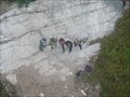
 view gallery view galleryNE34.8 km | MNR Unstamped Disk - Gogama, ON in Canadian Benchmarks MNR Unstamped Disk set in a concrete dam. posted by: 13acres location: Ontario, Canada date approved: 07/28/2020 last visited: never |
 view gallery view galleryNE34.8 km | 04LA005 Water Survey of Canada - Gogama, ON in Canadian Benchmarks A Water Survey of Canada bronze disk stamped 02-33 posted by: 13acres location: Ontario, Canada date approved: 07/28/2020 last visited: never |
 view gallery view galleryNE34.8 km |  Natural Spring - Gogama, ON Natural Spring - Gogama, ON
in Natural Springs A natural spring located on a bush road. posted by: 13acres location: Ontario, Canada date approved: 07/28/2020 last visited: never |
 view gallery view galleryNE35.7 km |  Forest Roads near Kenetogami Lake Forest Roads near Kenetogami Lake
in Offroad Trails Old forest road used by loggers and snowmobile clubs. Leads to a great lookout point. posted by: northernpenguin location: Ontario, Canada date approved: 08/02/2010 last visited: 07/26/2010 |
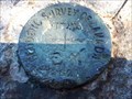
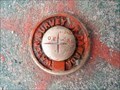
 view gallery view galleryNE39.8 km | Ontario Natural Resources Control Survey Marker 2010770004 in Canadian Benchmarks The marker is located just north of the posted coordinates and geocache GCKT8F, beneath an abandoned tower structure at the top of the hill. posted by: Team Goju location: Ontario, Canada date approved: 06/29/2008 last visited: 07/13/2019 |
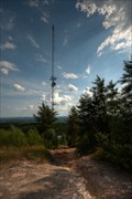
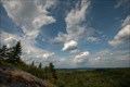 view gallery view galleryNE39.8 km |  Viewpoint near Kenetogami Lake Viewpoint near Kenetogami Lake
in Scenic Overlooks There is a large hill here with an abandoned tower on top. Great panoramic views of the area. posted by: northernpenguin location: Ontario, Canada date approved: 07/29/2010 last visited: 07/27/2010 |
 view gallery view gallery S58.1 km S58.1 km
| Hwy 144 - Cartier + 20.35 Miles North in Canadian Benchmarks Minitry of Transportation Vertical Control located 20.35 Miles North of Cartier on Highway #144 posted by: bandsaw1 location: Ontario, Canada date approved: 02/01/2011 last visited: never |
 view gallery view galleryS59.2 km | Hwy 144 Cartier + 19.5 Miles in Canadian Benchmarks Ministry of Transportation Vertical Control Benchmark along Highway 144 19.5 Miles North of Cartier, Ontario posted by: bandsaw1 location: Ontario, Canada date approved: 02/01/2011 last visited: never |
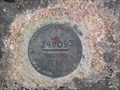 view gallery view galleryS60.5 km | Hwy 144 Cartier + 18.60 MI (Station: 00819748093) in Canadian Benchmarks Ministry of Transportation Benchmark. Locaed atop Rock posted by: bandsaw1 location: Ontario, Canada date approved: 02/01/2011 last visited: never |
 view gallery view galleryS63.9 km | 00820150633 Disk - Halfway Lake, ON in Canadian Benchmarks Bronze MTO survey disk mounted in rock face posted by: 13acres location: Ontario, Canada date approved: 07/17/2019 last visited: never |
 view gallery view galleryS83.7 km | Horizontal Control - MTO BM at Johnson's Farm - Hwy 144 in Canadian Benchmarks MTO Horizontal Control Benchmark located by Johnson's Farm lake near Cartier, Ontario on Highway 144 posted by: bandsaw1 location: Ontario, Canada date approved: 05/06/2010 last visited: never |
 view gallery view galleryS86.1 km | Cartier Plus 1.1Mi in Canadian Benchmarks Located 1.1 Mi from Cartier, East side of road posted by: bandsaw1 location: Ontario, Canada date approved: 03/28/2010 last visited: 04/17/2010 |
 view gallery view gallery E86.3 km E86.3 km
|  Ishpatina Ridge, Temagami Ishpatina Ridge, Temagami
in Mountain Summits At 2,274 feet, it is the very highest point in the province of Ontario.
posted by: deeregal location: Ontario, Canada date approved: 07/24/2007 last visited: 07/11/2022 |
 view gallery view gallerySE88 km |  PREMIER - Maire de Québec - FIRST - Mayor of Quebec, Québec, Québec PREMIER - Maire de Québec - FIRST - Mayor of Quebec, Québec, Québec
in First of its Kind Le 1er mai 1833, Elzéar Bédard devient le premier maire de la Cité de Québec. On May 1, 1833, Elzéar Bédard became the first mayor of Quebec City. posted by: Weathervane location: Québec, Canada date approved: 02/02/2019 last visited: 06/12/2019 |
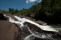 view gallery view galleryS103.5 km |  Onaping Falls Onaping Falls
in Waterfalls A waterfall made famous by A.Y. Jackson posted by: northernpenguin location: Ontario, Canada date approved: 08/03/2010 last visited: 05/10/2012 |
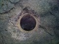
 view gallery view galleryS103.6 km |  Sudbury Basin - Onaping River Sudbury Basin - Onaping River
in Impact Craters The Sudbury Basin, also known as Sudbury Structure is a major geologic structure in Ontario, Canada. It is the second-largest known impact crater or astrobleme on Earth, as well as one of the oldest. posted by: Skyecat location: Ontario, Canada date approved: 06/11/2012 last visited: 05/19/2013 |
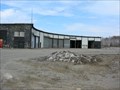 view gallery view gallerySE109.4 km |  CN Roundhouse - Capreol, Ontario CN Roundhouse - Capreol, Ontario
in Railway Roundhouses This roundhouse is in Canadian National's yard in Capreol, Ontario. It is no longer used for engine repairs, as the turntable has been removed, but is still used by the railway as a mechanical building. posted by: Cedar Grove Seekers location: Ontario, Canada date approved: 04/24/2008 last visited: 12/04/2010 |
 view gallery view gallerySE114.6 km |  Dairy Queen - Val Caron, ON Dairy Queen - Val Caron, ON
in Dairy Queen Restaurants Dairy Queen in Val Caron, ON posted by: SweetPea57 location: Ontario, Canada date approved: 01/20/2015 last visited: 04/22/2023 |
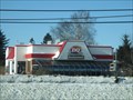
 view gallery view gallerySE114.7 km |  Tim Hortons - Val Caron, ON Tim Hortons - Val Caron, ON
in Tim Horton's Restaurants Tim Hortons restaurant posted by: SweetPea57 location: Ontario, Canada date approved: 01/22/2015 last visited: 04/22/2023 |
 view gallery view gallerySE114.7 km |  Subway - Val Caron, ON Subway - Val Caron, ON
in Subway Restaurants Subway restaurant posted by: SweetPea57 location: Ontario, Canada date approved: 01/20/2015 last visited: 04/22/2023 |
 view gallery view gallerySE114.9 km |  A & W Restaurant in Val Caron, ON A & W Restaurant in Val Caron, ON
in A + W Restaurants Local A&W Restaurant in Val Caron, ON posted by: SweetPea57 location: Ontario, Canada date approved: 01/20/2015 last visited: 04/22/2023 |
 view gallery view gallery N116.8 km N116.8 km
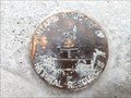
| 98U041 Survey Marker - Timmins, Ontario in Canadian Benchmarks A bronze survey marker, located in the rock on the north side of Kamiskotia Road. posted by: RCA777 location: Ontario, Canada date approved: 11/03/2010 last visited: 07/15/2011 |
|