 view gallery view gallery NE15.4 km NE15.4 km
|   Kletterpark - Langenbruck, BL, Switzerland Kletterpark - Langenbruck, BL, Switzerland
in Ropes Course A rope course south of Langenbruck. posted by:  fi67 fi67 location: Basel Landschaft, Switzerland date approved: 08/10/2013 last visited: 08/15/2015 |
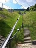 view gallery view galleryNE15.4 km |  Solarbob - Langenbruck, BL, Switzerland Solarbob - Langenbruck, BL, Switzerland
in Roller Coasters A solar powered roller coaster in the hills south of Langenbruck. posted by: fi67 location: Basel Landschaft, Switzerland date approved: 07/21/2013 last visited: 08/15/2015 |
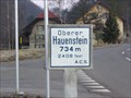 view gallery view galleryNE15.8 km |  Oberer Hauenstein 734m, Langenbruck, Schweiz Oberer Hauenstein 734m, Langenbruck, Schweiz
in Elevation Signs Oberer Hauenstein bei Langenbruck. posted by:  Heli67 Heli67 location: Basel Landschaft, Switzerland date approved: 02/26/2008 last visited: 03/09/2013 |
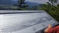
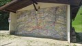 view gallery view gallery N15.9 km N15.9 km
|  Topographic Map on a Barn - Reigoldswil, BL, Switzerland Topographic Map on a Barn - Reigoldswil, BL, Switzerland
in Murals A barn near the top station of the gondola lift of Reigoldswil has a huge topographic map of the closer area on the front side. posted by: fi67 location: Basel Landschaft, Switzerland date approved: 06/04/2017 last visited: never |
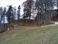
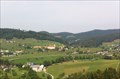
 view gallery view galleryN15.9 km |  View over Mümliswil from Chellenchöpfli - Waldenburg, BL, Switzerland View over Mümliswil from Chellenchöpfli - Waldenburg, BL, Switzerland
in Cityscapes A view over Mümliswil from the lookout point on Chellenchöpfli. posted by: fi67 location: Basel Landschaft, Switzerland date approved: 06/09/2017 last visited: never |
 view gallery view galleryN15.9 km |  Panorama from Chellenchöpfli - Waldenburg, BL, Switzerland Panorama from Chellenchöpfli - Waldenburg, BL, Switzerland
in Orientation Tables An orientation table on the lookout point on Chellenchöpfli. posted by: fi67 location: Basel Landschaft, Switzerland date approved: 06/12/2017 last visited: never |
 view gallery view galleryN16.1 km | LRW Waldseilpark Wasserfallen - Reigoldswil, BL, Switzerland in Ropes Course A tree top rope course near the upper station of the aerial lift to Wasserfallen. posted by: fi67 location: Basel Landschaft, Switzerland date approved: 11/09/2010 last visited: never |
 view gallery view galleryN16.1 km |  Hinteri Egg, the Highest Point in the Canton of Basel-Landschaft - Waldenburg, BL, Switzerland Hinteri Egg, the Highest Point in the Canton of Basel-Landschaft - Waldenburg, BL, Switzerland
in Geographic High Points Hinteri Egg is a peak of the eastern Jurassic range south of Reigoldswil and west of Waldenburg, it is the highest point of the canton of Basel-Landschaft. posted by: fi67 location: Basel Landschaft, Switzerland date approved: 06/09/2017 last visited: never |
 view gallery view galleryN16.1 km |  Hinteri Egg - Waldenburg, BL, Switzerland Hinteri Egg - Waldenburg, BL, Switzerland
in Mountain Summits Hinteri Egg is a peak of the eastern Jurassic range south of Reigoldswil and west of Waldenburg, it is the highest point of the canton of Basel-Landschaft. posted by: fi67 location: Basel Landschaft, Switzerland date approved: 07/26/2017 last visited: never |
 view gallery view galleryN16.3 km |  Wasserfallenhof - Reigoldswil, BL, Switzerland Wasserfallenhof - Reigoldswil, BL, Switzerland
in Alpaca and Llama Farms This llama farm is near the top station of the gondola lift of Reigoldswil. posted by: fi67 location: Basel Landschaft, Switzerland date approved: 06/06/2017 last visited: never |
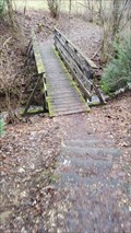
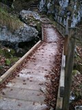 view gallery view galleryN16.4 km |  Footbridge at Jägerweg - Wasserfallen, Reigoldswil, BL, Switzerland Footbridge at Jägerweg - Wasserfallen, Reigoldswil, BL, Switzerland
in Hiking Path Footbridges A footbridge on a hiking trail from Wasserfallen to Reigoldswil posted by: fi67 location: Basel Landschaft, Switzerland date approved: 11/10/2010 last visited: never |
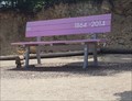 view gallery view galleryN16.4 km |  Giant Bench - Reigoldswil, BL, Switzerland Giant Bench - Reigoldswil, BL, Switzerland
in Ginormous Everyday Objects One of the giant benches that were donated by BLKB on occasion on the 150th anniversary. posted by: fi67 location: Basel Landschaft, Switzerland date approved: 06/14/2017 last visited: never |
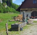
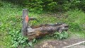 view gallery view galleryN16.4 km |  Wooden Fountain near Hinter Egg - Waldenburg, BL, Switzerland Wooden Fountain near Hinter Egg - Waldenburg, BL, Switzerland
in Fountains A wooden fountain on a hiking trail on Wasserfallen south of Reigoldswil. posted by: fi67 location: Basel Landschaft, Switzerland date approved: 06/04/2017 last visited: never |
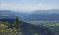
 view gallery view galleryN16.4 km |  Wildblick - Reigoldswil, BL, Switzerland Wildblick - Reigoldswil, BL, Switzerland
in Scenic Overlooks The view to the northwest from Wasserfallen. posted by: fi67 location: Basel Landschaft, Switzerland date approved: 06/04/2017 last visited: never |
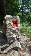
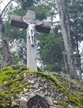 view gallery view galleryN16.6 km |  Kreuz Meltingerbergstrasse - Meltingen, SO, Switzerland Kreuz Meltingerbergstrasse - Meltingen, SO, Switzerland
in Christian Crosses A stone cross in a bend of a rural road south of Meltingen. posted by: fi67 location: Solothurn, Switzerland date approved: 02/28/2021 last visited: never |
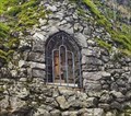 view gallery view galleryN16.6 km |  Antoniusnische - Meltingen, SO, Switzerland Antoniusnische - Meltingen, SO, Switzerland
in Outdoor Altars An outdoor altar with a statue of Saint Anthony in a bend of a rural road south of Meltingen. posted by: fi67 location: Solothurn, Switzerland date approved: 02/28/2021 last visited: never |
 view gallery view galleryNE16.7 km | Brunnen Hofgut Spittel - Langenbruck, BL, Switzerland in Fountains An old stone fountain at the entrance of Hofgut Spittel in the north of Langenbruck. posted by: fi67 location: Basel Landschaft, Switzerland date approved: 06/06/2017 last visited: never |
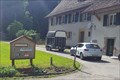 view gallery view galleryNE16.7 km |  Bed and Breakfast Hofgut Spittel - Langenbruck, BL, Switzerland Bed and Breakfast Hofgut Spittel - Langenbruck, BL, Switzerland
in Bed and Breakfast Hofgut Spittel is a farm estate in the north of Langenbruck offering Bed and Breakfast. posted by: fi67 location: Basel Landschaft, Switzerland date approved: 06/06/2017 last visited: never |
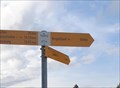 view gallery view galleryN16.7 km | Ängiberg - 872 m - Lauwil, BL, Switzerland in Elevation Signs A signpost with an elevation marker at a hiking trail between Passwang and Reigoldswil. posted by: fi67 location: Basel Landschaft, Switzerland date approved: 04/21/2024 last visited: never |
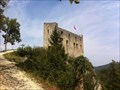 view gallery view galleryN17.1 km |  Ruine Gilgenberg - Zullwil, SO, Switzerland Ruine Gilgenberg - Zullwil, SO, Switzerland
in Castles A picturesque castle ruin on a hill south of Zullwil. posted by: fi67 location: Solothurn, Switzerland date approved: 12/10/2015 last visited: never |
 view gallery view galleryN17.1 km |  Ruine Gilgenberg - Zullwil, SO, Switzerland Ruine Gilgenberg - Zullwil, SO, Switzerland
in Austrian and Swiss National Heritage Sites A picturesque castle ruin on a hill south of Zullwil. posted by: fi67 location: Solothurn, Switzerland date approved: 12/10/2015 last visited: never |
 view gallery view galleryN17.1 km |  Tectonic Window Oberkirch - Zullwil, SO, Switzerland Tectonic Window Oberkirch - Zullwil, SO, Switzerland
in Places of Geologic Significance The plateau of Oberkirch is the only known tectonic window in the northern Jurassic Range. posted by: fi67 location: Solothurn, Switzerland date approved: 12/11/2015 last visited: never |
 view gallery view galleryN17.1 km | Footbridge Riedengraben - Meltingen, SO, Switzerland in Hiking Path Footbridges A footbridge over the creek Riedengraben south of Meltingen. posted by: fi67 location: Solothurn, Switzerland date approved: 02/28/2021 last visited: never |
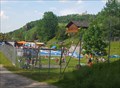 view gallery view galleryNE17.2 km |  Freibad - Waldenburg, BL, Switzerland Freibad - Waldenburg, BL, Switzerland
in Public Swimming Pools The public outdoor pool of Waldenburg. posted by: fi67 location: Basel Landschaft, Switzerland date approved: 06/22/2017 last visited: never |
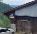
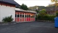 view gallery view galleryN17.4 km |  Feuerwehr Lauwil Feuerwehr Lauwil
in Firehouses The firehouse of Lauwil in the rear of the town hall. posted by: fi67 location: Basel Landschaft, Switzerland date approved: 10/25/2016 last visited: never |
|