 view gallery view gallery SW5.5 km SW5.5 km
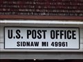
|   Sidnaw MI 49961 Sidnaw MI 49961
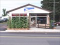
in U.S. Post Offices This Post Office is on State Highway M-28 at Erie Street in Sidnaw, Michigan. posted by:  PeterNoG PeterNoG location: Michigan date approved: 07/22/2013 last visited: 07/06/2013 |
 view gallery view gallery E10.1 km E10.1 km
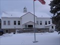
|  Covington School - Covington, MI Covington School - Covington, MI
in Former Schools The former Covington School is a former 2 room school house located in Covington, Michigan. posted by: Team B Squared location: Michigan date approved: 01/29/2009 last visited: 06/12/2015 |
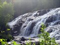
 view gallery view gallery N10.6 km N10.6 km
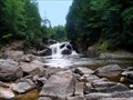
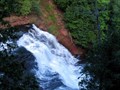
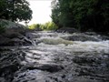
|  Sturgeon Falls Sturgeon Falls
in Waterfalls This is a MUST SEE!!! posted by:  Trent & Kittie Trent & Kittie location: Michigan date approved: 09/17/2006 last visited: 10/13/2006 |
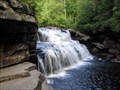 view gallery view gallery NE17.1 km NE17.1 km
| Canyon Falls in Waterfalls A Roadside Park Waterfall posted by: Trent & Kittie location: Michigan date approved: 09/12/2006 last visited: 08/25/2014 |
 view gallery view gallerySW18.2 km |  Smokey Bear at Kenton Ranger Station - Trout Creek, MI Smokey Bear at Kenton Ranger Station - Trout Creek, MI
in Smokey Bear Sign Sightings Smokey Bear sign located in Trout Creek, Michigan. posted by: machard location: Michigan date approved: 08/02/2019 last visited: never |
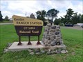 view gallery view gallery W18.2 km W18.2 km
|  Kenton Ranger Station - Trout Creek, MI Kenton Ranger Station - Trout Creek, MI
in Ranger Stations Ranger Station in Ottawa National Forest. posted by: machard location: Michigan date approved: 07/30/2019 last visited: never |
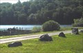
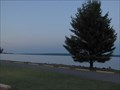 view gallery view galleryNE26.9 km |  Keweenaw Bay Keweenaw Bay
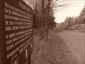
in Michigan Historical Markers On the east side of US-41 in a roadside park next to Keweenaw Bay. Plenty of parking in the roadside park. posted by: S5280ft location: Michigan date approved: 08/20/2006 last visited: 07/06/2007 |
 view gallery view galleryNE26.9 km | L'Anse - Lac Vieux Desert Trail in Michigan Historical Markers The marker is at the Bishop Baraga Shrine. It's hard to describe how to get there. It is on the south side of US-41 between L'anse and Baraga. Follow the signs to the Bishop Baraga Shrine. Park at the shrine parking lot. posted by: S5280ft location: Michigan date approved: 08/20/2006 last visited: 08/25/2014 |
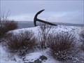 view gallery view galleryNE28.5 km |  L'Anse Harbor Anchor - L'Anse, MI L'Anse Harbor Anchor - L'Anse, MI
in Anchors Anchor near L'Anse town harbor in L'Anse, Michigan. posted by: Team B Squared location: Michigan date approved: 01/28/2009 last visited: 06/09/2015 |
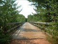 view gallery view galleryW32.8 km |  Agate Falls/Bergland to Sidnaw Rail Trail Agate Falls/Bergland to Sidnaw Rail Trail
in Railroad Bridges If you are afraid of heights this converted railroad bridge is not for you. posted by: Archived2012 location: Michigan date approved: 09/13/2007 last visited: 07/30/2012 |
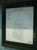 view gallery view galleryW33 km |  Agate Falls Roadside Park Agate Falls Roadside Park
in 'You Are Here' Maps You are at Agate Falls Roadside Park. posted by: Archived2012 location: Michigan date approved: 09/06/2007 last visited: 07/30/2012 |
 view gallery view galleryW33 km | Agate Falls in Waterfalls Roadside Park Waterfall posted by: Trent & Kittie location: Michigan date approved: 09/11/2006 last visited: 08/20/2018 |
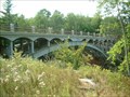 view gallery view galleryW33 km |  Ontonagon River Middle Branch Bridge Ontonagon River Middle Branch Bridge
in Engineering Landmarks This ASCE Michigan Historic Civil Engineering Landmark Bridge was completed in 1929 and can be found when you visit Agate Falls. posted by: Archived2012 location: Michigan date approved: 09/11/2007 last visited: 08/20/2018 |
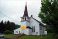
 view gallery view galleryNE33.8 km |  Zeba Indian Mission United Methodist Church Zeba Indian Mission United Methodist Church
in This Old Church On the southeast corner of Whirl-I-Gig and Zeba Roads. Take Main Street/Skanee north out of L'Anse and after about 2.9 miles, bear left on Whirl-I-Gig until you come to Zeba Road on your right. Plenty of streetside parking. posted by: S5280ft location: Michigan date approved: 07/06/2008 last visited: never |
 view gallery view galleryNE33.8 km | Zeba Indian United Methodist Church in Michigan Historical Markers On the southeast corner of Whirl-I-Gig and Zeba Roads (I'm not kidding). Take Main Street/Skanee north out of L'Anse and after about 2.9 miles, bear left on Whirl-I-Gig until you come to Zeba Road on your right. Plenty of streetside parking. posted by: S5280ft location: Michigan date approved: 08/20/2006 last visited: never |
 view gallery view galleryNE33.8 km |  Kewawenon Mission - Zeba, MI Kewawenon Mission - Zeba, MI
in U.S. National Register of Historic Places On the southeast corner of Whirl-I-Gig and Zeba Roads. Take Main Street/Skanee north out of L'Anse and after about 2.9 miles, bear left on Whirl-I-Gig until you come to Zeba Road on your right. Plenty of streetside parking. posted by: S5280ft location: Michigan date approved: 07/08/2008 last visited: never |
 view gallery view galleryNE33.8 km |  59 Zeba Indian Church, L'Anse, MI 59 Zeba Indian Church, L'Anse, MI
in Historic United Methodist Sites On the southeast corner of Whirl-I-Gig and Zeba Roads. Take Main Street/Skanee north out of L'Anse and after about 2.9 miles, bear left on Whirl-I-Gig until you come to Zeba Road on your right. Plenty of streetside parking posted by: S5280ft location: Michigan date approved: 07/06/2008 last visited: 10/25/2011 |
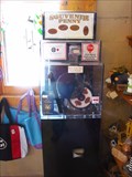 view gallery view gallerySW38.5 km |  Bond Falls Outpost - Paulding, MI Bond Falls Outpost - Paulding, MI
in Penny Smashers This penny smasher is located at Bond Falls Outpost, 12371 Bond Falls Road Paulding, MI, 49912 posted by: DougandSandra location: Michigan date approved: 08/17/2013 last visited: 04/20/2021 |
 view gallery view gallerySW38.6 km | Bond Falls in Waterfalls This is a Michigan Senic Site and a MUST see! posted by: Trent & Kittie location: Michigan date approved: 09/12/2006 last visited: 08/20/2018 |
 view gallery view gallerySW38.6 km | Bond Falls Scenic Area in 'You Are Here' Maps You are at the beginning of a boardwalk that will take you to Bond Falls Scenic Area. Enjoy your walk. posted by: Archived2012 location: Michigan date approved: 09/07/2007 last visited: 09/19/2015 |
 view gallery view galleryW38.8 km | Bruce Crossing MI 49912 in U.S. Post Offices Bruce Crossing MI 49912 posted by: kJfishman location: Michigan date approved: 08/25/2012 last visited: never |
 view gallery view gallerySW39.3 km | Mex-i-min-e Falls in Waterfalls This waterfall is located by a nice campground posted by: Trent & Kittie location: Michigan date approved: 09/13/2006 last visited: 08/08/2009 |
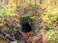 view gallery view gallery NW40.4 km NW40.4 km
| ") Abandoned Mine Entrance Near Mass City, MI Abandoned Mine Entrance Near Mass City, MI
in Cave Entrances (Artificial) Abandoned mine entrance northeast of Mass City, Michigan. posted by: Team B Squared location: Michigan date approved: 01/20/2009 last visited: 08/17/2010 |
 view gallery view galleryE42 km |  Lake Michigamme west end Lake Michigamme west end
in Boat Ramps Lake Michigamme west end posted by: kJfishman location: Michigan date approved: 08/28/2009 last visited: 08/28/2009 |
 view gallery view gallerySW44.7 km |  The Paulding Mystery Lights! The Paulding Mystery Lights!
in Weird Story Locations Located in Watersmeet Michigan, the
Paulding Light is a natural phenomenon
which must be seen to be believed!
( a few beers help! )
posted by: Pokagon Nature Center location: Michigan date approved: 09/18/2006 last visited: 08/20/2018 |
|