 view gallery view gallery N0.3 km N0.3 km
|   Sault Ste. Marie International Bridge Sault Ste. Marie International Bridge
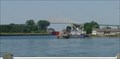
in Arch Bridges Sault Ste. Marie International Bridge posted by:  stagunner stagunner location: Ontario, Canada date approved: 08/10/2008 last visited: 03/28/2023 |
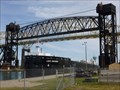
 view gallery view galleryN0.5 km |  International Railroad Bridge - Swing Span - Sault Ste. Marie, ON International Railroad Bridge - Swing Span - Sault Ste. Marie, ON
in Truss Bridges Built in 1895 the International Railroad Bridge is still in operation today. posted by:  mTn_biKer65 mTn_biKer65 location: Ontario, Canada date approved: 03/23/2013 last visited: 09/09/2022 |
 view gallery view gallery NE0.6 km NE0.6 km
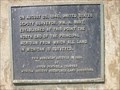
|  "THE "CHICORA" INCIDENT 1870" -- Sault Ste. Marie "THE "CHICORA" INCIDENT 1870" -- Sault Ste. Marie
in Ontario Provincial Plaques This plaque is located in Sault Ste. Marie near the Canadian locks. posted by: wildernessmama location: Ontario, Canada date approved: 07/23/2019 last visited: 09/26/2022 |
 view gallery view gallery S0.8 km S0.8 km
|  USA to Canada - I-75 - Sault Ste Marie, Michigan. USA to Canada - I-75 - Sault Ste Marie, Michigan.
in Border Crossings International border crossing using the I-75 across the 'International Bridge' over St. Marys River and the Soo Locks, between the twin cities of Sault Ste Marie, Michigan, USA and Sault Ste. Marie, Ontario, Canada. posted by: veritas vita location: Michigan date approved: 06/11/2012 last visited: 08/09/2020 |
 view gallery view galleryS0.8 km |  Sault Ste Marie - International Bridge - Michigan, USA. Sault Ste Marie - International Bridge - Michigan, USA.
in Wikipedia Entries International border crossing using the I-75 road across the 'International Road Bridge' over St. Marys River and the Soo Locks, between the twin cities of Sault Ste Marie, Michigan, USA and Sault Ste. Marie, Ontario, Canada. posted by: veritas vita location: Michigan date approved: 01/20/2013 last visited: 08/09/2020 |
 view gallery view galleryS0.8 km |  International Road Bridge - USA/Canada - Sault Ste Marie, Michigan International Road Bridge - USA/Canada - Sault Ste Marie, Michigan
in Satellite Imagery Oddities International border crossing using the I-75 road across the 'International Road Bridge' over St. Marys River and the Soo Locks, between the twin cities of Sault Ste Marie, Michigan, USA and Sault Ste. Marie, Ontario, Canada. posted by: veritas vita location: Michigan date approved: 01/21/2013 last visited: 08/09/2020 |
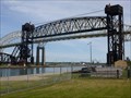
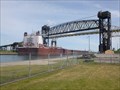 view gallery view galleryS0.8 km |  International Railway Bridge - Sault Ste Marie - Michigan - USA. International Railway Bridge - Sault Ste Marie - Michigan - USA.
in Railroad Bridges A single track, combination series of bridges including a vertical lift railroad bridge, double bascule bridge, and swing bridge, over the St. Marys River and Soo Locks, between Sault Ste Marie, Michigan, USA and Sault Ste. Marie, Ontario, Canada. posted by: veritas vita location: Michigan date approved: 06/08/2012 last visited: 08/09/2020 |
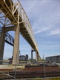
 view gallery view galleryS0.8 km |  International Bridge - Sault Ste Marie - Michigan - USA. International Bridge - Sault Ste Marie - Michigan - USA.
in Vertical Lift Bridges A vertical lift railroad bridge, part of the International Bridge over the St. Marys River between Sault Ste Marie, Michigan, USA and the twin city of Sault Ste. Marie, Ontario, Canada. posted by: veritas vita location: Michigan date approved: 10/16/2012 last visited: 01/19/2022 |
 view gallery view galleryS0.8 km | International Bridge - Sault Ste Marie - Michigan - USA. in Moving Bridges A vertical lift railroad bridge, double bascule bridge, and swing bridge, over the St. Marys River between Sault Ste Marie, Michigan, USA and Sault Ste. Marie, Ontario, Canada. posted by: veritas vita location: Michigan date approved: 06/08/2012 last visited: 01/19/2022 |
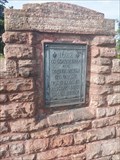
 view gallery view galleryS0.8 km |  Principal Meridian - Sault Ste. Marie - Michigan, USA. Principal Meridian - Sault Ste. Marie - Michigan, USA.
in U.S. Historic Survey Stones and Monuments A plaque dated August 25, 1840. marking the point from which all land in Michigan is surveyed. Located at Sault Ste. Marie, Upper Peninsula, Michigan. posted by: veritas vita location: Michigan date approved: 01/09/2013 last visited: 12/19/2016 |
 view gallery view galleryNE0.8 km |  FIRST - White Men to see the St Mary Rapids - Sault Ste Marie, ON FIRST - White Men to see the St Mary Rapids - Sault Ste Marie, ON
in First of its Kind Cairn and marker memorializing the arrival of the first white men to the area in 1622. posted by: jiggs11 location: Ontario, Canada date approved: 09/08/2020 last visited: 09/26/2022 |
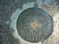 view gallery view galleryNE1 km |  26U1627 26U1627
in Canadian Benchmarks Sault Ste Marie posted by: tiki-4 location: Ontario, Canada date approved: 10/20/2005 last visited: 02/27/2023 |
 view gallery view galleryNE1 km |  Bicycle Tender - Sault Ste Marie, Ontario, Canada Bicycle Tender - Sault Ste Marie, Ontario, Canada
in Bicycle Tenders Traditional bike tender posted by: lp5324 location: Ontario, Canada date approved: 07/25/2008 last visited: 09/11/2022 |
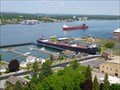
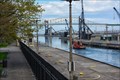
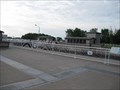 view gallery view galleryNE1 km |  The Sault Locks - Sault Ste Marie, Ontario, Canada The Sault Locks - Sault Ste Marie, Ontario, Canada
in Waterway Locks, Planes and Lifts The Sault locks are located on Canal Street in Sault Ste Marie, Ontario, Canada posted by: lp5324 location: Ontario, Canada date approved: 08/02/2008 last visited: 03/28/2023 |
 view gallery view galleryNE1 km |  Sault Ste. Marie Canal National Historic Site of Canada Sault Ste. Marie Canal National Historic Site of Canada
in Canadian National Historic Sites Located on Canal St in Sault Ste Marie, Ontario The lock was the first to be electrically-powered, 1888-94 posted by: lp5324 location: Ontario, Canada date approved: 07/27/2008 last visited: 09/09/2022 |
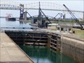
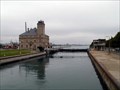 view gallery view gallery SE1 km SE1 km
| Soo Locks, Sault Saint Marie MI/Ont in Waterway Locks, Planes and Lifts The locks that bypass the rapids of the St. Mary's River connecting Lake Superior to Lake Huron. posted by: S5280ft location: Michigan date approved: 08/26/2007 last visited: 06/26/2016 |
 view gallery view gallerySE1 km | St. Marys River (Michigan–Ontario) in Wikipedia Entries The St. Marys River drains Lake Superior, starting at the end of Whitefish Bay and flowing 75 miles southeast into Lake Huron, For its entire length it is an international border, separating Michigan in the United States from Ontario, Canada. posted by: veritas vita location: Michigan date approved: 09/10/2012 last visited: 07/11/2018 |
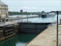
 view gallery view gallerySE1 km | Soo Locks - Sault Saint Marie - Michigan, USA. in Wikipedia Entries Soo locks are a set of parallel locks which enable ships to travel between Lake Superior and the lower Great Lakes. They are located on the St. Marys River between the Upper Peninsula of the US state of Michigan and the Canadian province of Ontario. posted by: veritas vita location: Michigan date approved: 09/10/2012 last visited: 07/11/2018 |
 view gallery view gallerySE1 km | Largest Lock in the USA - Sault Saint Marie - Michigan. in Satellite Imagery Oddities Soo locks are a set of parallel locks which enable ships to travel between Lake Superior and the lower Great Lakes. They are located on the St. Marys River between the Upper Peninsula of the US state of Michigan and the Canadian province of Ontario. posted by: veritas vita location: Michigan date approved: 01/22/2013 last visited: 06/30/2019 |
 view gallery view gallerySE1 km |  Soo Locks - Sault Saint Marie - Michigan, USA. Soo Locks - Sault Saint Marie - Michigan, USA.
in Official Local Tourism Attractions Soo locks are a set of parallel locks which enable ships to travel between Lake Superior and the lower Great Lakes. They are located on the St. Marys River between the Upper Peninsula of the US state of Michigan and the Canadian province of Ontario. posted by: veritas vita location: Michigan date approved: 09/10/2012 last visited: 07/11/2018 |
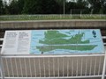
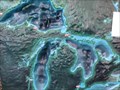 view gallery view gallerySE1 km |  3D Map - Great Lakes - Sault St Marie - Michigan, USA. 3D Map - Great Lakes - Sault St Marie - Michigan, USA.
in 3D Map Models of Our World and Beyond The 3D model of the Great Lakes is located in the Soo Locks Visitor centre. The locks bypass the rapids of the St. Mary's River connecting Lake Superior to Lake Huron. posted by: veritas vita location: Michigan date approved: 05/26/2013 last visited: 06/01/2013 |
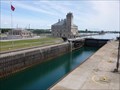
 view gallery view gallerySE1 km |  St. Mary's Falls Canal - Sault Ste. Marie MI St. Mary's Falls Canal - Sault Ste. Marie MI
in U.S. National Register of Historic Places The first lock was built in 1855 to allow ships to navigate the 22 foot difference in elevation between Lake Superior and Lake Huron. It has been declared a National Historic Landmark. posted by: nomadwillie location: Michigan date approved: 10/22/2015 last visited: 06/30/2019 |
 view gallery view gallerySE1 km |  Soo Lock Ship Canal - Sault Ste. Marie MI Soo Lock Ship Canal - Sault Ste. Marie MI
in American Guide Series The first lock was built in 1855 to allow ships to navigate the 22 foot difference in elevation between Lake Superior and Lake Huron. It has been declared a National Historic Landmark. posted by: nomadwillie location: Michigan date approved: 10/23/2015 last visited: 06/30/2019 |
 view gallery view gallerySE1 km |  Great Lakes Shipwreck Hitorical Society- Sault Ste. Marie MI Great Lakes Shipwreck Hitorical Society- Sault Ste. Marie MI
in Historical Society Headquarters Home to the Great Lakes Shipwreck Historical Society, the building was used as the US Weather Bureau Builiding. posted by: nomadwillie location: Michigan date approved: 10/23/2015 last visited: 07/09/2019 |
 view gallery view gallerySE1 km |  Great Lakes Shipwreck Museum - Sault Ste. Marie MI Great Lakes Shipwreck Museum - Sault Ste. Marie MI
in Maritime Museums Home to the Great Lakes Shipwreck Historical Society, the building was used as the US Weather Bureau Builiding. posted by: nomadwillie location: Michigan date approved: 10/23/2015 last visited: 07/09/2019 |
|