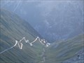
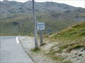
 view gallery view gallery N8.5 km N8.5 km
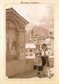
|   The Old Bridge in Bormio, Italy The Old Bridge in Bormio, Italy
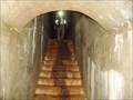
in Photos Then and Now Medieval Combo bridge over the Frodolfo stream in Bormio. posted by:  Anneke Anneke location: Lombardia, Italy date approved: 07/19/2011 last visited: never |
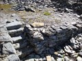
 view gallery view gallery NE16.1 km NE16.1 km
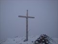
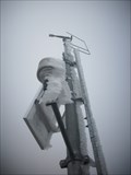
|  Kriegerdenkmal Dreisprachenspitze - Stilfser Joch, Italy Kriegerdenkmal Dreisprachenspitze - Stilfser Joch, Italy
in World War I Memorials and Monuments Kriegerdenkmal Dreisprachenspitze - Stilfser Joch, Italy posted by:  luzzi-reloaded luzzi-reloaded location: Piemonte, Italy date approved: 10/05/2011 last visited: 02/17/2012 |
 view gallery view galleryNE16.6 km |  Passo Platigliole 2908m - Italy Passo Platigliole 2908m - Italy
in Elevation Signs Passo Platigliole 2908m - Italy posted by: luzzi-reloaded location: Piemonte, Italy date approved: 04/26/2012 last visited: 04/27/2012 |
 view gallery view galleryNE16.6 km |  Monte Scorluzzo - Stilfser Joch, Italy Monte Scorluzzo - Stilfser Joch, Italy
in Wikipedia Entries Monte Scorluzzo - Stilfser Joch, Italy posted by: luzzi-reloaded location: Lombardia, Italy date approved: 05/15/2012 last visited: 05/16/2012 |
 view gallery view galleryNE16.6 km |  Monte Scorluzzo 3095m - Stilfser Joch, Italy Monte Scorluzzo 3095m - Stilfser Joch, Italy
in Scenic Hikes Monte Scorluzzo 3095m - Stilfser Joch, Italy posted by: luzzi-reloaded location: Lombardia, Italy date approved: 10/14/2011 last visited: 02/16/2012 |
 view gallery view galleryNE16.6 km |  Monte Scorluzzo 3094m - Stilfser Joch, Italy Monte Scorluzzo 3094m - Stilfser Joch, Italy
in Mountain Summits Monte Scorluzzo 3094m - Stilfser Joch, Italy posted by: luzzi-reloaded location: Lombardia, Italy date approved: 10/18/2011 last visited: 02/16/2012 |
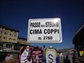
 view gallery view galleryNE16.9 km | Stelvio Pass, Italy (2758m) in Elevation Signs Highest point in the road over col Stelvio. posted by: tijgetje location: Lombardia, Italy date approved: 08/31/2007 last visited: 08/21/2014 |
 view gallery view galleryNE16.9 km |  Stilfser Joch - Lombardei/Vinschgau - Italy Stilfser Joch - Lombardei/Vinschgau - Italy
in Border Crossings Stilfser Joch - Lombardei/Vinschgau - Italy posted by: luzzi-reloaded location: Lombardia, Italy date approved: 10/20/2011 last visited: 08/21/2014 |
 view gallery view galleryNE16.9 km | Stilfser Joch - Lombardei/Vinschgau - Italy in Wikipedia Entries Stilfser Joch - Lombardei/Vinschgau - Italy posted by: luzzi-reloaded location: Lombardia, Italy date approved: 05/15/2012 last visited: 08/21/2014 |
 view gallery view galleryNE17.1 km | Dreisprachenspitze 2843m - Italy in Mountain Summits Dreisprachenspitze 2843m - Italy posted by: luzzi-reloaded location: Lombardia, Italy date approved: 10/19/2011 last visited: 08/21/2014 |
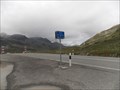
 view gallery view galleryN17.5 km | Umbrailpass - Italy/Swizerland in Wikipedia Entries Umbrailpass - Italy/Swizerland posted by: luzzi-reloaded location: Lombardia, Italy date approved: 05/14/2012 last visited: 07/19/2013 |
 view gallery view galleryN17.5 km | Umbrailpass - Italy/Swizerland in Border Crossings Umbrailpass - Italy/Swizerland posted by: luzzi-reloaded location: Graubünden, Switzerland date approved: 10/17/2011 last visited: 07/19/2013 |
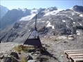
 view gallery view galleryN17.7 km | Umbrail Pass, Switzerland (2149m) in Elevation Signs Highest point in the mountain road over the col de Umbrail. posted by: tijgetje location: Graubünden, Switzerland date approved: 08/31/2007 last visited: 07/11/2014 |
 view gallery view galleryNE17.9 km | Lehmpruchlager Stilfser Joch, Italy in Scenic Hikes Lehmpruchlager Stilfser Joch, Italy posted by: luzzi-reloaded location: Piemonte, Italy date approved: 11/01/2011 last visited: 08/21/2014 |
 view gallery view galleryNE18.5 km | Goldseestellung Stilfer Joch - Italy in Scenic Hikes Goldseestellung Stilfer Joch - Italy posted by: luzzi-reloaded location: Lombardia, Italy date approved: 10/26/2011 last visited: 08/21/2014 |
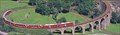 view gallery view gallery SW23 km SW23 km
|  Bernina Express - Brusio Bridge - Ostschweiz, Switzerland Bernina Express - Brusio Bridge - Ostschweiz, Switzerland
in Railroad Bridges Elicoidal Bridge For Bernina Express posted by: GattoNeroTeam location: Graubünden, Switzerland date approved: 01/01/2007 last visited: 08/08/2008 |
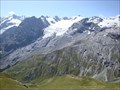
 view gallery view galleryNE24.3 km | Hintere Schöntaufspitze (3325 m) in Mountain Summits The "Hintere Schöntaufspitze" is a nice mountain with a weather control station on top posted by: KingfisherTeam location: Trentino–Alto Adige, Italy date approved: 07/28/2010 last visited: 07/18/2010 |
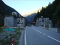 view gallery view galleryNE24.6 km |  Sperre Gomagoi - Italy Sperre Gomagoi - Italy
in Military Installations Sperre Gomagoi - Italy posted by: luzzi-reloaded location: Piemonte, Italy date approved: 05/24/2012 last visited: 05/24/2012 |
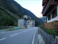 view gallery view galleryNE24.6 km |  Sperre Gomagoi - Italy Sperre Gomagoi - Italy
in Historic Forts Sperre Gomagoi - Italy posted by: luzzi-reloaded location: Piemonte, Italy date approved: 03/12/2011 last visited: 02/19/2012 |
 view gallery view gallery W25.4 km W25.4 km
|  Passo del Bernina - Graubünden, Switzerland Passo del Bernina - Graubünden, Switzerland
in Named Mountain Gaps The Bernina Pass (el. 2328 m.) (Italian: Passo del Bernina) is a high mountain pass in the Bernina Range of the Alps. posted by: Noe1 location: Graubünden, Switzerland date approved: 09/27/2014 last visited: never |
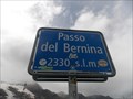 view gallery view galleryW25.4 km | Passo del Bernina - Graubünden, Switzerland - 2330 m in Elevation Signs The Bernina Pass Italian: Passo del Bernina) is a high mountain pass in the Bernina Range of the Alps. posted by: Noe1 location: Graubünden, Switzerland date approved: 09/24/2014 last visited: never |
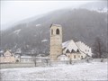 view gallery view galleryN27.4 km |  Benedictine Convent of St John at Müstair Benedictine Convent of St John at Müstair
in World Heritage Sites During our way to the Lago di Garda in Italy we took a side trip to Müstair.
The coordinates represents the entrance of this site. posted by: Stream_Green location: Graubünden, Switzerland date approved: 04/06/2008 last visited: 08/06/2012 |
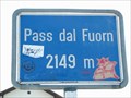 view gallery view galleryN32.2 km | Fuorn Pass, Switzerland (2149m) in Elevation Signs Highest point in the road over col de Fuorn posted by: tijgetje location: Graubünden, Switzerland date approved: 08/31/2007 last visited: 07/19/2013 |
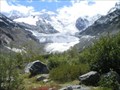 view gallery view galleryW32.5 km |  Morteratsch - Switzerland Morteratsch - Switzerland
in Glaciers nature trail about glaciers posted by: tetejaunecache location: Graubünden, Switzerland date approved: 09/16/2006 last visited: 02/20/2023 |
 view gallery view galleryNE35.4 km | Bunkler Tartscher Bühel - Tartsch, Italy in Military Installations Bunkler Tartscher Bühel - Tartsch, Italy posted by: luzzi-reloaded location: Trentino–Alto Adige, Italy date approved: 09/30/2012 last visited: 08/31/2019 |
|