 view gallery view gallery S5.8 km S5.8 km
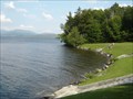
|   Rangeley Lake State Park Beach - Maine Rangeley Lake State Park Beach - Maine
in Swimming Holes Rangeley Lake State Park has two swimming areas; this is the beach area. posted by:  macdonr macdonr location: Maine date approved: 09/03/2006 last visited: never |
 view gallery view gallery SE6.4 km SE6.4 km
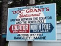
|  "Doc" Grant's Sign - Rangeley, Maine "Doc" Grant's Sign - Rangeley, Maine
in Direction and Distance Arrows "Doc" Grant's Restaurant was famously "Halfway between the Equator and the North Pole," 3,107 miles from each. posted by: macdonr location: Maine date approved: 09/03/2006 last visited: 12/27/2017 |
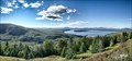
 view gallery view galleryS9.5 km |  Shelton Noyes Overlook - Coplin, ME Shelton Noyes Overlook - Coplin, ME
in Scenic Roadside Look-Outs The Shelton Noyes Overlook is along ME17, which is the Rangeley Lakes National Scenic Byway also. The view of Rangeley Lake is blocked at the road level. The overlook is slightly elevated, and the view has been cleared to see Rangeley Lake. posted by:  nomadwillie nomadwillie location: Maine date approved: 01/19/2023 last visited: never |
 view gallery view galleryS9.5 km |  Shelton Noyes Overlook - Rangeley Lakes National Scenic Byway - Coplin, ME Shelton Noyes Overlook - Rangeley Lakes National Scenic Byway - Coplin, ME
in National Scenic Byways The Shelton Noyes Overlook is along ME17, which is the Rangeley Lakes National Scenic Byway also. The view of Rangeley Lake is blocked at the road level. The overlook is slightly elevated, and the view has been cleared to see Rangeley Lake. posted by: nomadwillie location: Maine date approved: 01/09/2023 last visited: never |
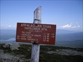
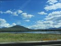
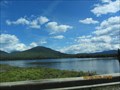
 view gallery view galleryS17.1 km | Height of Land Overlook - Roxbury, ME in Scenic Roadside Look-Outs Height of Land is the iconic view of the Rangeley Lake area. The view includes Mooselookmeguntic Lake and on a clear day you can see the White Mountains in the distance. posted by: nomadwillie location: Maine date approved: 01/19/2023 last visited: never |
 view gallery view galleryS17.1 km | Height of Land Overlook - Rangeley Lakes Scenic Byway - Roxbury, ME in National Scenic Byways Height of Land is the iconic view of the Rangeley Lake area. The view includes Mooselookmeguntic Lake and on a clear day you can see the White Mountains in the distance. posted by: nomadwillie location: Maine date approved: 01/09/2023 last visited: never |
 view gallery view gallery E17.4 km E17.4 km
|  Saddleback Mtn. Appalachian Trail - Maine, USA Saddleback Mtn. Appalachian Trail - Maine, USA
in Appalachian Trail Saddleback Mtn. Appalachian Trail is located in Maine, USA. posted by: tatie location: Maine date approved: 04/02/2012 last visited: 06/15/2019 |
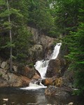 view gallery view gallerySE21.6 km |  Smalls Falls Smalls Falls
in Waterfalls Smalls Falls is a magnificent cascading horsetail waterfall in western Maine. posted by: macdonr location: Maine date approved: 08/23/2006 last visited: 08/26/2010 |
 view gallery view gallery W26.7 km W26.7 km
|  Bennett-Bean Bridge - Wilson Mills, ME Bennett-Bean Bridge - Wilson Mills, ME
in Covered Bridges The Bennett-Bean Bridge is located in the Aziscoos Valley Camping Area off Route 16, near Wilson Mills, Maine. posted by: macdonr location: Maine date approved: 09/10/2006 last visited: 04/13/2005 |
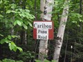 view gallery view galleryE29.8 km |  Caribou Pond Road - Maine, USA Caribou Pond Road - Maine, USA
in Offroad Trails Caribou Pond Trail is located in Carrabassett Valley, Maine. posted by: tatie location: Maine date approved: 02/21/2012 last visited: 08/14/2018 |
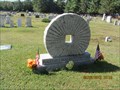
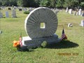 view gallery view gallery NE29.9 km NE29.9 km
|  Grist Mill Stone, Eustis, Maine Grist Mill Stone, Eustis, Maine
in Old Agricultural Equipment This is an old grain grinding stone. posted by: Queens Blessing location: Maine date approved: 10/19/2012 last visited: 09/26/2023 |
 view gallery view galleryNE29.9 km |  Grist Mill Stone, Eustis, Maine Grist Mill Stone, Eustis, Maine
in Millstones This is an old grain grinding stone, now used as a headstone in a cemetery. posted by: Queens Blessing location: Maine date approved: 08/17/2013 last visited: 09/26/2023 |
 view gallery view galleryNE30.1 km |  Flagstaff, Maine Flagstaff, Maine
in Ghost Towns Flagstaff, Maine no longer exists. (It was drowned by Flagstaff Lake in the 1950s). posted by: Queens Blessing location: Maine date approved: 10/19/2012 last visited: 09/24/2023 |
 view gallery view galleryNE30.1 km |  Flagstaff Memorial Chapel, Eustis, Maine Flagstaff Memorial Chapel, Eustis, Maine
in Churchyard Cemeteries This small chapel has a cemetery adjacent to it. posted by: Queens Blessing location: Maine date approved: 10/19/2012 last visited: 09/26/2023 |
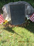
 view gallery view galleryNE30.1 km |  Flagstaff World War II Memorial, Eustis, Maine Flagstaff World War II Memorial, Eustis, Maine
in World War II Memorials / Monuments Flagstaff, Maine is a ghost town that disappeared under the waters of Flafstaff Lake in the 1940s; this monument honors the WWII veterans from the former town. posted by: Queens Blessing location: Maine date approved: 10/18/2012 last visited: 09/24/2023 |
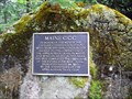
 view gallery view galleryNE30.1 km |  Benedict Arnold in Flagstaff, Maine Benedict Arnold in Flagstaff, Maine
in Maine Historical Markers Flagstaff, Maine was named in honor of an action by Benedict Arnold. posted by: Queens Blessing location: Maine date approved: 10/20/2012 last visited: 09/26/2023 |
 view gallery view galleryE30.6 km |  CCC - Appalachian Trail in Maine CCC - Appalachian Trail in Maine
in Civilian Conservation Corps CCC - Appalachian Trail in Maine marker is located on the ridge trail between the Sugarloaf and Spaulding Mountains in Maine. posted by: tatie location: Maine date approved: 09/01/2014 last visited: 09/23/2018 |
 view gallery view galleryNE31.1 km |  Cranberry Peak Cranberry Peak
in Mountain Summits Cranberry Peak part of the Bigelow Range in Stratton Maine posted by: Team2hunt location: Maine date approved: 10/01/2009 last visited: 09/26/2009 |
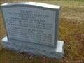 view gallery view gallery SW31.7 km SW31.7 km
|  Bean'Family- Wentwoth Location - New Hampshire Bean'Family- Wentwoth Location - New Hampshire
in Graves Mentioning a Cause of Death Graves of Unusual Deaths on the road posted by: gemeloj location: New Hampshire date approved: 05/27/2018 last visited: 10/16/2018 |
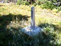 view gallery view gallery N32.2 km N32.2 km
|  US-Canada Boundary marker 446 US-Canada Boundary marker 446
in U.S. Historic Survey Stones and Monuments Obelisk marking the northern border of the US from the Treaty of Washington. Set in 1842, renewed 1916. posted by: NewEnglandHiker location: Maine date approved: 09/16/2012 last visited: 12/29/2017 |
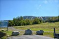 view gallery view galleryE32.5 km |  Sugarloaf - Carrabassett Valley ME Sugarloaf - Carrabassett Valley ME
in Winter Sports Locations Sugarloaf (formerly Sugarloaf/USA) is a ski area and resort located on Sugarloaf Mountain in Carrabassett Valley, western Maine posted by: nomadwillie location: Maine date approved: 10/02/2015 last visited: 07/10/2019 |
 view gallery view galleryE32.5 km |  Sugarloaf - Carrabassett Valley ME Sugarloaf - Carrabassett Valley ME
in Town Clocks Sugarloaf (formerly Sugarloaf/USA) is a ski area and resort located on Sugarloaf Mountain in Carrabassett Valley, western Maine posted by: nomadwillie location: Maine date approved: 10/05/2015 last visited: never |
 view gallery view galleryNE38.6 km |  "BELOW", Dead River and Flagstaff, Maine "BELOW", Dead River and Flagstaff, Maine
in Immortalized in Lyrics The towns of Dead River and Flagstaff were flooded; the song "Below" is said to be about this situation. posted by: Queens Blessing location: Maine date approved: 10/24/2012 last visited: 07/10/2019 |
 view gallery view galleryNE38.6 km |  Ghosts of Flagstaff and Dead River, Maine Ghosts of Flagstaff and Dead River, Maine
in Ghosts and Hauntings Flagstaff and Dead River were tiny towns in Maine that were flooded as part of a hydroelectric expansion project. Rumor has is that not everyone left before the town flooded. posted by: Queens Blessing location: Maine date approved: 10/22/2012 last visited: 08/18/2019 |
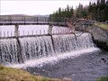 view gallery view gallery NW40.4 km NW40.4 km
|  Second Connecticut Lake-River - Pittsburg, NH Second Connecticut Lake-River - Pittsburg, NH
in Water Dams The three Connecticut Lakes in the far northern tip of New Hampshire are the origin of the mighty Connecticut River that forms most of the border between New Hampshire and Vermont. This dam is on the south end of the Second Connecticut Lake. posted by: silverquill location: New Hampshire date approved: 04/27/2007 last visited: 09/03/2012 |
|