 view gallery view gallery N1.3 km N1.3 km
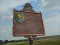
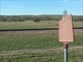
|   You Are Now on the 100° Meridian You Are Now on the 100° Meridian
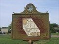
in South Dakota Historical Markers The 100th Meridian is significant historically. posted by:  plainsdrifter358 plainsdrifter358 location: South Dakota date approved: 07/24/2007 last visited: 07/18/2007 |
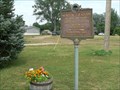 view gallery view gallery NE1.6 km NE1.6 km
| Mentor Graham in South Dakota Historical Markers Mentor Graham, the man who taught Abraham Lincoln posted by: plainsdrifter358 location: South Dakota date approved: 07/24/2007 last visited: 10/30/2011 |
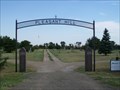 view gallery view gallery NW1.9 km NW1.9 km
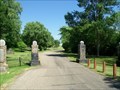
|  Pleasant Hill Cemetery, Blunt, South Dakota Pleasant Hill Cemetery, Blunt, South Dakota
in Worldwide Cemeteries A larger community cemetery west of town. posted by: NGComets location: South Dakota date approved: 08/07/2012 last visited: never |
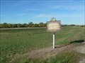
 view gallery view galleryNE2.1 km |  Blunt, South Dakota 57522 Blunt, South Dakota 57522
in U.S. Post Offices Small town post office. posted by: NGComets location: South Dakota date approved: 10/13/2009 last visited: never |
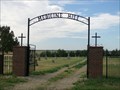 view gallery view gallery E20.3 km E20.3 km
| Medicine Hill Cemetery, Harrold, South Dakota in Worldwide Cemeteries A small community cemetery south of town on County Road 200. posted by: NGComets location: South Dakota date approved: 08/07/2012 last visited: never |
 view gallery view galleryE20.8 km | Harrold, South Dakota 57536 in U.S. Post Offices Small town post office. posted by: NGComets location: South Dakota date approved: 10/13/2009 last visited: never |
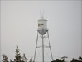
 view gallery view galleryE20.9 km |  Watertower, Harrold, South Dakota Watertower, Harrold, South Dakota
in Water Towers Watertower in a small town. posted by: NGComets location: South Dakota date approved: 10/13/2009 last visited: never |
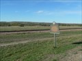
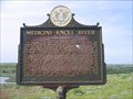 view gallery view gallery S21.1 km S21.1 km
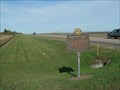
| Medicine Knoll River in South Dakota Historical Markers On September 22, 1804 Lewis & Clark passed by this river and camped a couple of miles up the Missouri. They called it Reuben River for Reuben Fields, one of their hunter. posted by: MNSearchers location: South Dakota date approved: 05/30/2007 last visited: 07/19/2007 |
 view gallery view galleryE21.1 km | St. John's Cemetery, Harrold, South Dakota in Worldwide Cemeteries A small Catholic cemetery southeast of town. posted by: NGComets location: South Dakota date approved: 08/07/2012 last visited: never |
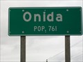 view gallery view galleryN23.3 km |  Population Sign, Onida Population Sign, Onida
in Population Signs Population 761 and county seat of Sully County, South Dakota. posted by: NGComets location: South Dakota date approved: 04/24/2012 last visited: never |
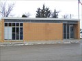 view gallery view galleryN23.5 km | Onida, South Dakota 57564 in U.S. Post Offices Small town post office. posted by: NGComets location: South Dakota date approved: 04/07/2011 last visited: 08/02/2013 |
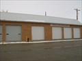 view gallery view galleryN23.7 km |  The Onida Fire Department The Onida Fire Department
in Firehouses Small town fire department posted by: NGComets location: South Dakota date approved: 04/07/2011 last visited: 07/02/2011 |
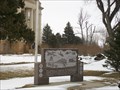 view gallery view galleryN23.8 km |  Veterans Memorial, Onida, South Dakota Veterans Memorial, Onida, South Dakota
in Non-Specific Veteran Memorials Memorial on the corner of the County Courthouse in Onida, SD. posted by: NGComets location: South Dakota date approved: 04/08/2011 last visited: 08/02/2013 |
 view gallery view galleryN23.8 km | Watertower, Onida, South Dakota in Water Towers Small town watertower posted by: NGComets location: South Dakota date approved: 04/07/2011 last visited: 07/02/2011 |
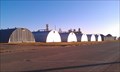 view gallery view galleryN24 km |  Quonset Huts - Grain Storage - Onida, SD Quonset Huts - Grain Storage - Onida, SD
in Quonset Huts A even dozen quonset huts lined up along the north side of the road near the grain elevator in Onida, SD posted by: dbrockhouse location: South Dakota date approved: 11/20/2011 last visited: never |
 view gallery view gallery SW24.6 km SW24.6 km
| Ancient Indian Fortress in South Dakota Historical Markers Pre-Columbus Indian fortress includes 2000 yards of perimeter palisades, bastions for enfilading arrow fire, encompassing 50 acres. posted by: plainsdrifter358 location: South Dakota date approved: 10/06/2006 last visited: 05/29/2007 |
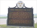 view gallery view galleryS25.6 km | First Permanent Fur Post in South Dakota Historical Markers The partnership of Registre Loisel and Hugh Heney in 1802 set a fur post on Cedar Island. posted by: MNSearchers location: South Dakota date approved: 05/30/2007 last visited: 05/27/2011 |
 view gallery view gallerySW27.5 km | Civilian Conservation Corps Camp S-207 in South Dakota Historical Markers CCC Camp that built the Arikara Dam and developed the park at Farm Island near Pierre. posted by: plainsdrifter358 location: South Dakota date approved: 10/06/2006 last visited: 09/03/2012 |
 view gallery view gallerySW27.5 km | The First (Old) Fort Sully 1863 ~ 1866 in South Dakota Historical Markers The first (Old) Fort Sully 1863-1866 located along the Missouri River just east of Pierre, SD posted by: plainsdrifter358 location: South Dakota date approved: 10/06/2006 last visited: 09/03/2012 |
 view gallery view gallerySW28.6 km |  U-Haul TR: Mitchell, SD U-Haul TR: Mitchell, SD
in U-Haul SuperGraphics Welcome to Mitchell, South Dakota, "Home of the World's Only Corn Palace". posted by:  Team Cloverfrogs Team Cloverfrogs location: South Dakota date approved: 08/01/2009 last visited: 11/02/2022 |
 view gallery view gallerySW29.1 km | Riverside Cemetery, Pierre, South Dakota in Worldwide Cemeteries A wonderful cemetery with rolling hills and numerous trees and bushes throughout the gravestones. Gravel road and paved roads intersect the graves. Elevation 1502 posted by: NGComets location: South Dakota date approved: 08/05/2019 last visited: never |
 view gallery view gallerySW29.1 km | U-Haul #96: South Dakota in U-Haul SuperGraphics Part of Central United States, South Dakota is a fascinating area that features interesting geological and historical opportunities. Pierre, the capital city is well worth a visit! posted by: The Blue Quasar location: South Dakota date approved: 02/14/2009 last visited: 01/20/2023 |
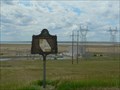
 view gallery view gallerySW29.1 km | The Missouri River was HH~ S to FT. Thompson/N to Mobridge in South Dakota Historical Markers South to Ft. Thompson SD.
North to Oahe and Mobridge. posted by: MNSearchers location: South Dakota date approved: 05/30/2007 last visited: 05/28/2007 |
 view gallery view gallery W29.8 km W29.8 km
| Sioux Indian Mosaic in South Dakota Historical Markers An Arikara was honored by his enemy, the Sioux, with cairn (mound of stones) marked with the Sioux Tribal sign of the turtle. posted by: plainsdrifter358 location: South Dakota date approved: 10/07/2006 last visited: 09/06/2019 |
 view gallery view galleryW30.4 km | The Missouri River Historic Highway ~ Oahe Overlook in South Dakota Historical Markers Historic Sites and Activities along the Missouri River from 1804 to the present day. posted by: plainsdrifter358 location: South Dakota date approved: 06/28/2006 last visited: 09/06/2019 |
|