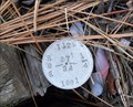
 view gallery view gallery NE0.8 km NE0.8 km
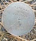
|   T12S R9E S34 35 T13S R9E S3 2 COR - Jefferson County, OR T12S R9E S34 35 T13S R9E S3 2 COR - Jefferson County, OR
in Public Land Survey Marks PLSS section corner set by R. Oman in 1980; National Forest Survey Corner Visitation Card, Index File No. 1775 posted by:  Cooke17513 Cooke17513 location: Oregon date approved: 10/28/2013 last visited: never |
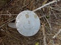
 view gallery view gallery NW0.8 km NW0.8 km
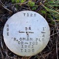
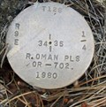
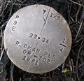
| T12S R9E S34 T13S R9E S3 1/4 COR - Jefferson County, OR in Public Land Survey Marks PLSS quarter corner set by R. Oman in 1981; National Forest Survey Corner Visitation Card, Index File No. 1575 posted by: Cooke17513 location: Oregon date approved: 11/16/2013 last visited: never |
 view gallery view gallery S1 km S1 km
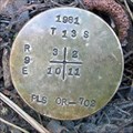
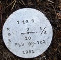
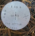
| T13S R9E S3 2 10 11 COR - Jefferson County, OR in Public Land Survey Marks PLSS section corner set by R. Oman in 1981; National Forest Survey Corner Visitation Card, Index File No. 1755 posted by: Cooke17513 location: Oregon date approved: 10/28/2013 last visited: never |
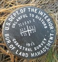
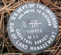
 view gallery view gallery SW1 km SW1 km
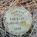
| T13S R9E S3 10 1/4 COR - Jefferson County, OR in Public Land Survey Marks PLSS quarter corner set by USDA-Forest Service, R. Oman in 1981; National Forest Survey Corner Visitation Card, Index File No. 1555 posted by: Cooke17513 location: Oregon date approved: 11/17/2013 last visited: never |
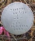
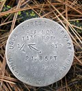
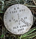 view gallery view galleryS1.4 km | T13S R9E S10 N 1/16 COR RM - Jefferson County, OR in Public Land Survey Marks PLSS reference monument set by USDA-Forest Service, Fred Ast in 1985; National Forest Survey Corner Visitation Card, Index File No. 1556 posted by: Cooke17513 location: Oregon date approved: 11/19/2013 last visited: never |
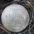
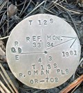 view gallery view galleryNW1.4 km | T12S R9E S33 34 T13S R9E S4 3 COR S4 RM - Jefferson County, OR in Public Land Survey Marks PLSS reference monuments set by R. Oman in 1981; National Forest Survey Corner Visitation Card, Index File No. 1375 posted by: Cooke17513 location: Oregon date approved: 11/16/2013 last visited: never |
 view gallery view gallery N1.6 km N1.6 km
| T12S R9E S34 35 1/4 COR - Jefferson County, OR in Public Land Survey Marks PLSS quarter corner set by R. Oman in 1980; National Forest Survey Corner Visitation Card, Index File No. 1773 posted by: Cooke17513 location: Oregon date approved: 11/30/2013 last visited: never |
 view gallery view gallerySW1.6 km | T13S R9E S4 3 9 10 COR S10 RM - Jefferson County, OR in Public Land Survey Marks PLSS reference monument set by USDI-Bureau of Land Management, J.E. Jelley in a 1966 cadastral survey; National Forest Survey Corner Visitation Card, Index File No. 1355 posted by: Cooke17513 location: Oregon date approved: 11/17/2013 last visited: never |
 view gallery view gallerySW1.6 km | T13S R9E S10 NW 1/16 COR - Jefferson County, OR in Public Land Survey Marks PLSS sixteenth corner set by USDA-Forest Service, Fred Ast in 1985; National Forest Survey Corner Visitation Card, Index File No. 1456 posted by: Cooke17513 location: Oregon date approved: 11/19/2013 last visited: never |
 view gallery view galleryN1.6 km | T12S R9E S34 C 1/4 COR - Jefferson County, OR in Public Land Survey Marks PLSS center quarter corner set by USDA-Forest Service, Fred Ast in 1985; National Forest Survey Corner Visitation Card, Index File No. 1573 posted by: Cooke17513 location: Oregon date approved: 11/20/2013 last visited: never |
 view gallery view galleryS1.8 km | T13S R9E S10 11 1/4 COR - Jefferson County, OR in Public Land Survey Marks PLSS quarter corner set by USDA-Forest Service, R. Oman in 1981; National Forest Survey Corner Visitation Card, Index File No. 1757 posted by: Cooke17513 location: Oregon date approved: 10/28/2013 last visited: never |
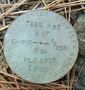
 view gallery view galleryN1.8 km | T12S R9E S34 C-E-SW-NE 1/256 COR - Jefferson County, OR in Public Land Survey Marks PLSS 256th corner set by USDA-Forest Service, Fred Ast in 1985; National Forest Survey Corner Visitation Card, Index File No. 1572-K posted by: Cooke17513 location: Oregon date approved: 11/30/2013 last visited: never |
 view gallery view galleryNW2.1 km | T12S R9E S33 34 1/4 COR - Jefferson County, OR in Public Land Survey Marks PLSS quarter corner set by R. Oman in 1981; National Forest Survey Corner Visitation Card, Index File No. 1373 posted by: Cooke17513 location: Oregon date approved: 11/20/2013 last visited: never |
 view gallery view gallerySW2.1 km | T13S R9E S9 10 1/4 COR S10 RM - Jefferson County, OR in Public Land Survey Marks PLSS reference monument set by USDA-Forest Service, Fred Ast in 1985; National Forest Survey Corner Visitation Card, Index File No. 1357 posted by: Cooke17513 location: Oregon date approved: 11/19/2013 last visited: never |
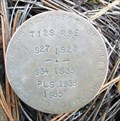
 view gallery view galleryN2.4 km | T12S R9E S27 34 E-W-E 1/256 COR - Jefferson County, OR in Public Land Survey Marks PLSS 256th corner set by USDA-Forest Service, Fred Ast in 1985; National Forest Survey Corner Visitation Card, Index File No. 1571-C posted by: Cooke17513 location: Oregon date approved: 12/01/2013 last visited: never |
 view gallery view galleryN2.4 km | T12S R9E S27 26 34 35 COR - Jefferson County, OR in Public Land Survey Marks PLSS section corner set by USDA-Forest Service, Fred Ast in 1985; National Forest Survey Corner Visitation Card, Index File No. 1771 posted by: Cooke17513 location: Oregon date approved: 11/30/2013 last visited: never |
 view gallery view galleryN2.4 km | T12S R9E S27 34 1/4 COR -Jefferson County, OR in Public Land Survey Marks PLSS quarter corner set by R. Oman in 1981; National Forest Survey Corner Visitation Card, Index File No. 1571 posted by: Cooke17513 location: Oregon date approved: 12/01/2013 last visited: never |
 view gallery view galleryS2.6 km | T13S R9E S10 11 15 14 COR - Jefferson County, OR in Public Land Survey Marks PLSS section corner set by USDI-Bureau of Land Management in 1966;
National Forest Survey Corner Visitation Card, Index File No. 1759 posted by: Cooke17513 location: Oregon date approved: 10/23/2013 last visited: never |
 view gallery view galleryS2.6 km | T13S R9E S10 15 1/4 COR - Jefferson County, OR in Public Land Survey Marks PLSS quarter corner set by USDI-Bureau of Land Management in a 1966 cadastral survey; National Forest Survey Corner Visitation Card, Index File No. 1559 posted by: Cooke17513 location: Oregon date approved: 11/14/2013 last visited: never |
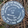
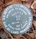
 view gallery view galleryN2.7 km |  USDA Forest Service 27 Camera Point USDA Forest Service 27 Camera Point
in U.S. Benchmarks Silver USDA Forest Service disk mounted on a rod. posted by: Tbird2LM location: Oregon date approved: 05/17/2011 last visited: never |
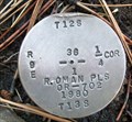
 view gallery view galleryNW2.7 km | T12S R9E S28 27 33 34 COR - Jefferson County, OR in Public Land Survey Marks PLSS section corner set by R. Oman in 1981; National Forest Survey Corner Visitation Card, Index File No. 1371 posted by: Cooke17513 location: Oregon date approved: 11/20/2013 last visited: never |
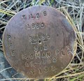
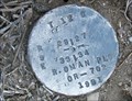
 view gallery view gallery E2.7 km E2.7 km
| T12S R9E S36 T13S R9E S1 1/4 COR - Jefferson County, OR in Public Land Survey Marks PLSS quarter corner set by R. Oman in 1980; National Forest Survey Corner Visitation Card, Index File No. 2375 posted by: Cooke17513 location: Oregon date approved: 11/03/2013 last visited: 09/07/2012 |
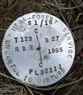 view gallery view galleryN2.7 km | T12S R9E S27 S 1/16 COR - Jefferson County, OR in Public Land Survey Marks PLSS sixteenth corner set by USDA-Forest Service, Walt Miller in 1995; National Forest Survey Corner Visitation Card, Index File No. 1570 posted by: Cooke17513 location: Oregon date approved: 12/01/2013 last visited: never |
 view gallery view gallerySW2.9 km | T13S R9E S9 10 16 15 COR S10 RM - Jefferson County, OR in Public Land Survey Marks PLSS reference monument set by USDI-Bureau of Land Management in a 1966 cadastral survey; National Forest Survey Corner Visitation Card, Index File No. 1359 posted by: Cooke17513 location: Oregon date approved: 11/14/2013 last visited: never |
 view gallery view galleryNW3.1 km | T12S R9E S28 27 S 1/16 COR - Jefferson County, OR in Public Land Survey Marks PLSS sixteenth corner set by USDA-Forest Service, Fred Ast in 1982; National Forest Survey Corner Visitation Card, Index File No. 1370 posted by: Cooke17513 location: Oregon date approved: 11/20/2013 last visited: never |
|