 view gallery view gallery S16.3 km S16.3 km
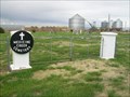
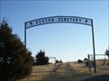
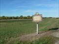
|   Medicine Creek Cemetery, Presho, South Dakota Medicine Creek Cemetery, Presho, South Dakota
in Worldwide Cemeteries Located in Lyman County, South Dakota, along Old US Highway 16. Elevation 1812. posted by:  NGComets NGComets location: South Dakota date approved: 07/30/2014 last visited: never |
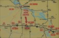
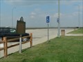
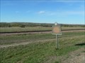
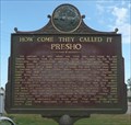 view gallery view galleryS16.9 km |  How Come They Called It Presho How Come They Called It Presho
in South Dakota Historical Markers This South Dakota Historical Marker is on the south side of Hwy 16 opposite Oak Avenue in Presho, South Dakota. posted by: PeterNoG location: South Dakota date approved: 11/10/2016 last visited: 10/13/2023 |
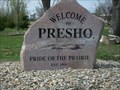 view gallery view galleryS16.9 km |  Welcome to Presho, South Dakota Welcome to Presho, South Dakota
in Welcome Signs Halfway between Sioux Falls and Rapid City, SD. Slogan is "Pride of the Prairie." posted by: NGComets location: South Dakota date approved: 05/10/2012 last visited: never |
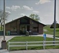
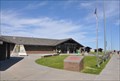 view gallery view galleryS17.7 km |  Presho Rest Area Presho Rest Area
in Highway Rest Areas This Rest Area is located on the north side of Interstate Highway 90 at Milepost 221, about 4 miles west of Presho, South Dakota. posted by: brwhiz location: South Dakota date approved: 02/11/2013 last visited: 08/08/2023 |
 view gallery view galleryS17.7 km |  Presho Westbound Rest Area Presho Westbound Rest Area
in 'You Are Here' Maps You Are Here at the Presho Rest Area on the north side of Interstate Highway 90 at milepost 221 about 4 miles west of Presho, South Dakota. posted by: brwhiz location: South Dakota date approved: 12/16/2012 last visited: 08/02/2015 |
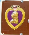 view gallery view galleryS17.7 km |  Purple Heart Highway - South Dakota Purple Heart Highway - South Dakota
in George Washington Historic Mark in Presho Rest Area, I-90 WB posted by: YoSam. location: South Dakota date approved: 01/04/2022 last visited: 08/08/2023 |
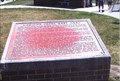
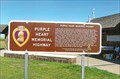 view gallery view galleryS17.7 km |  Purple Heart Memorial Highway - Presho Rest Area, I-90 WB, SD Purple Heart Memorial Highway - Presho Rest Area, I-90 WB, SD
in Non-Specific Veteran Memorials Steel sign memorial posted by: YoSam. location: South Dakota date approved: 09/07/2015 last visited: 08/08/2023 |
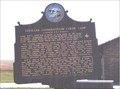
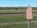
 view gallery view galleryS17.7 km | Medicine Creek Rest Area in South Dakota Historical Markers ThisHistorical Marker is mounted on a brick base in the Presho Westbound Rest Area on the north side of Interstate Highway 90 at Milepost 221, about 4 miles west of Presho, South Dakota. posted by: brwhiz location: South Dakota date approved: 02/19/2013 last visited: 08/02/2015 |
 view gallery view gallery SW18.2 km SW18.2 km
| Civilian Conservation Corps Camp SCS-2 on eastbound I-90 in South Dakota Historical Markers CCC Camp that built nearby Byre Dam, Fate Dam, and Brakke Dam during late 1935 and early 1936. posted by: plainsdrifter358 location: South Dakota date approved: 06/27/2006 last visited: 08/07/2008 |
 view gallery view gallerySW18.2 km |  CCC Camp SCS-2 ~ Lyman County, SD CCC Camp SCS-2 ~ Lyman County, SD
in Civilian Conservation Corps Companies: 2756 (Aug.1, '34 to Oct. 20, '34); 758 (May 29, '35 to Oct. 25, '35); 4726 (may 15, '38 to Oct 15, '38) 2770 (Later '35 to 1936). posted by: YoSam. location: South Dakota date approved: 12/18/2008 last visited: never |
 view gallery view gallerySW18.2 km | Medicine Creek in South Dakota Historical Markers Furtraders, railroads, tribes, place-names and rivers, the action that made the areas history. posted by: YoSam. location: South Dakota date approved: 03/15/2008 last visited: 09/07/2008 |
 view gallery view gallerySW18.2 km | I-90 EB Rest Area - Vivian, SD in Highway Rest Areas EB, now called the Purple Heart Hwy. posted by: YoSam. location: South Dakota date approved: 02/09/2019 last visited: never |
 view gallery view gallerySW20.4 km | Vivian Cemetery, Vivian, South Dakota in Worldwide Cemeteries Just east of town. Elevation at the entrance is 1916'. posted by: NGComets location: South Dakota date approved: 02/20/2012 last visited: never |
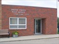 view gallery view gallerySW21.7 km |  Vivian, South Dakota 57576 Vivian, South Dakota 57576
in U.S. Post Offices Small town post office. posted by: NGComets location: South Dakota date approved: 08/20/2009 last visited: never |
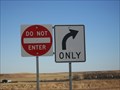 view gallery view gallerySW23.8 km |  Which Sign Should We Obey?, Vivian, South Dakota Which Sign Should We Obey?, Vivian, South Dakota
in Unusual Signs Unusual sign combination in a weigh station. posted by: NGComets location: South Dakota date approved: 02/15/2012 last visited: never |
 view gallery view gallery SE24.3 km SE24.3 km
| Kennebec, South Dakota 57544 in U.S. Post Offices Small town post office. posted by: NGComets location: South Dakota date approved: 08/20/2009 last visited: never |
 view gallery view gallerySE24.3 km |  Kennebec Fire Department, Kennebec, South Dakota Kennebec Fire Department, Kennebec, South Dakota
in Firehouses Small town fire department. posted by: NGComets location: South Dakota date approved: 08/20/2009 last visited: never |
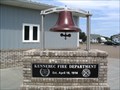 view gallery view gallerySE24.3 km |  Bell - Fire Department, Kennebec, South Dakota Bell - Fire Department, Kennebec, South Dakota
in Bells Retired fire bell on display. posted by: NGComets location: South Dakota date approved: 08/20/2009 last visited: never |
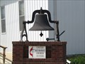 view gallery view gallerySE24.5 km | Bell - U.M. Church, Kennebec, South Dakota in Bells Church bell, retired from service. posted by: NGComets location: South Dakota date approved: 08/20/2009 last visited: never |
 view gallery view gallerySE24.8 km |  Watertower, Kennebec, South Dakota Watertower, Kennebec, South Dakota
in Water Towers Small town watertower. posted by: NGComets location: South Dakota date approved: 09/02/2009 last visited: never |
 view gallery view gallery NE29.1 km NE29.1 km
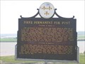
| First Permanent Fur Post in South Dakota Historical Markers The partnership of Registre Loisel and Hugh Heney in 1802 set a fur post on Cedar Island. posted by: MNSearchers location: South Dakota date approved: 05/30/2007 last visited: 05/27/2011 |
 view gallery view gallery N29.6 km N29.6 km
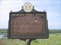
| Medicine Knoll River in South Dakota Historical Markers On September 22, 1804 Lewis & Clark passed by this river and camped a couple of miles up the Missouri. They called it Reuben River for Reuben Fields, one of their hunter. posted by: MNSearchers location: South Dakota date approved: 05/30/2007 last visited: 07/19/2007 |
 view gallery view galleryN33.2 km | Ancient Indian Fortress in South Dakota Historical Markers Pre-Columbus Indian fortress includes 2000 yards of perimeter palisades, bastions for enfilading arrow fire, encompassing 50 acres. posted by: plainsdrifter358 location: South Dakota date approved: 10/06/2006 last visited: 05/29/2007 |
 view gallery view gallery NW36.2 km NW36.2 km
| Civilian Conservation Corps Camp S-207 in South Dakota Historical Markers CCC Camp that built the Arikara Dam and developed the park at Farm Island near Pierre. posted by: plainsdrifter358 location: South Dakota date approved: 10/06/2006 last visited: 09/03/2012 |
 view gallery view galleryNW36.4 km | The First (Old) Fort Sully 1863 ~ 1866 in South Dakota Historical Markers The first (Old) Fort Sully 1863-1866 located along the Missouri River just east of Pierre, SD posted by: plainsdrifter358 location: South Dakota date approved: 10/06/2006 last visited: 09/03/2012 |
|