 view gallery view gallery NW0.3 km NW0.3 km
|   NH/VT on Hwy 25A NH/VT on Hwy 25A
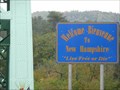
in Border Crossings A quiet border crossing on Hwy 25A (Bridge St) between New Hampshire and Vermont. posted by:  PeterNoG PeterNoG location: New Hampshire date approved: 12/12/2010 last visited: 10/03/2009 |
 view gallery view gallery SW4.7 km SW4.7 km
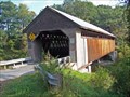
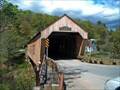
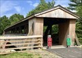
|  Edgell Bridge Edgell Bridge
in Covered Bridges This bridge has an unusual feature. U-shape piers are placed several feet from each end to help support this bridge which is south of Orford Village in Lyme, NH posted by:  CoveredBridgeGuy CoveredBridgeGuy location: New Hampshire date approved: 12/21/2008 last visited: never |
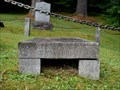 view gallery view galleryNW6 km |  Albert Southworth - West Fairlee, VT Albert Southworth - West Fairlee, VT
in Grave of a Famous Person Grave of Albert Southworth, half of the famous nineteenth-century photographic firm Southworth & Hawes of Boston, Massachusetts. posted by: hykesj location: Vermont date approved: 05/09/2022 last visited: never |
 view gallery view gallery W8.9 km W8.9 km
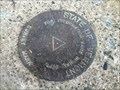
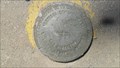
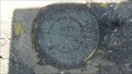
|  State of Vermont Highway Dept Survey Mark - W side of Lake Fairlee State of Vermont Highway Dept Survey Mark - W side of Lake Fairlee
in U.S. Benchmarks A State of Vermont Highway Department Survey Mark (with no unique identification) located on the southeast abutment of the concrete bridge carrying Robinson Hill Road over Lake Fairlee. posted by: Jay-7 location: Vermont date approved: 05/06/2013 last visited: never |
 view gallery view galleryW9.2 km |  Vermontasaurus - Junk Dinosaur - Post Mills VT Vermontasaurus - Junk Dinosaur - Post Mills VT
in Roadside Attractions Brian Boland recruited volunteers to help him transform a pile of scrap wood into a huge junk dinosaur sculpture in 2010. There's a museum of junk as well. posted by: nomadwillie location: Vermont date approved: 07/15/2017 last visited: never |
 view gallery view galleryW9.2 km |  Vermontasaurus - Post Mills VT Vermontasaurus - Post Mills VT
in Dinosaur Statues Brian Boland recruited volunteers to help him transform a pile of scrap wood into a huge junk dinosaur sculpture in 2010. There's a museum of junk as well posted by: nomadwillie location: Vermont date approved: 07/18/2017 last visited: never |
 view gallery view galleryW9.2 km |  Vermontasaurus - Post Mills VT Vermontasaurus - Post Mills VT
in Figurative Public Sculpture Brian Boland recruited volunteers to help him transform a pile of scrap wood into a huge junk dinosaur sculpture in 2010. There's a museum of junk as well. posted by: nomadwillie location: Vermont date approved: 07/16/2017 last visited: never |
 view gallery view gallery N9.8 km N9.8 km
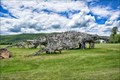
|  Bradford Village Historic District - Bradford VT Bradford Village Historic District - Bradford VT
in U.S. National Register of Historic Places This NRHP District extends for about a mile on both side of Main Street in Bradford, Vermont. It's 2500 acres and there are 81 contributing buildings. posted by: PeterNoG location: Vermont date approved: 05/09/2014 last visited: 10/03/2009 |
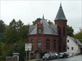
 view gallery view galleryN9.8 km |  Woods Library Building - Bradford VT Woods Library Building - Bradford VT
in Odd-Shaped Buildings This Odd-Shaped Building is the Wood Library Building on South Main Street just south of US Hwy 5 in Bradford, Vermont. posted by: PeterNoG location: Vermont date approved: 05/09/2014 last visited: 10/03/2009 |
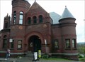
 view gallery view galleryN9.8 km |  Bradford Public Library - Bradford VT Bradford Public Library - Bradford VT
in Libraries This Library is on South Main Street just south of US Hwy 5 in Bradford, Vermont. posted by: PeterNoG location: Vermont date approved: 05/10/2014 last visited: 08/01/2022 |
 view gallery view galleryN9.8 km |  Woods Library Building - Bradford VT Woods Library Building - Bradford VT
in NRHP Historic Districts - Contributing Buildings This NRHP Contributing Building is the Wood Library Building on South Main Street just south of US Hwy 5 in Bradford, Vermont. posted by: PeterNoG location: Vermont date approved: 05/09/2014 last visited: 10/03/2009 |
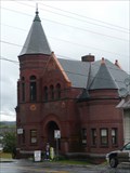 view gallery view galleryN9.8 km |  Woods Library Building - Bradford VT Woods Library Building - Bradford VT
in Victorian Style Architecture This Victorian Building is the Wood Library Building on South Main Street just south of US Hwy 5 in Bradford, Vermont. posted by: PeterNoG location: Vermont date approved: 05/09/2014 last visited: 10/03/2009 |
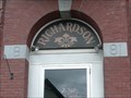 view gallery view galleryN10 km |  1891 - Bank Block - Bradford VT 1891 - Bank Block - Bradford VT
in Dated Buildings and Cornerstones This Dated Building is the Bank Block, on North Main Street at Bank Street in Bradford, Vermont. posted by: PeterNoG location: Vermont date approved: 05/10/2014 last visited: 10/03/2009 |
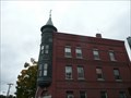 view gallery view galleryN10 km |  former Bradford Savings Bank - Bradford VT former Bradford Savings Bank - Bradford VT
in Converted Bank Buildings This Converted Bank Building, now Richardson Building, is on North Main Street at Bank Street in Bradford, Vermont. posted by: PeterNoG location: Vermont date approved: 05/11/2014 last visited: 10/03/2009 |
 view gallery view galleryN10 km | Bank Block (North Main Street) - Bradford VT in NRHP Historic Districts - Contributing Buildings This NRHP Contributing Building is the Bank Block, on North Main Street at Bank Street in Bradford, Vermont. posted by: PeterNoG location: Vermont date approved: 05/09/2014 last visited: 10/03/2009 |
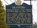 view gallery view galleryN10.6 km |  Bradford - Bradford VT Bradford - Bradford VT
in Vermont Historical Markers This Vermont Historical Marker is for Bradford - Home of Maker of 1st Globes and Birthplace of Adm. Clark. It on N Main St (Hwy 5) at Wrights Ave in Bradford, Vermont. posted by: PeterNoG location: Vermont date approved: 12/07/2010 last visited: 10/03/2009 |
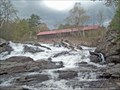 view gallery view gallerySW12.2 km | Sayers Bridge in Covered Bridges This bridge comes with a beautiful waterfall beneath. It is a wonderful place to have a picnic and enjoy this view. The truss is very unusual and has no duplicate in New England. posted by: CoveredBridgeGuy location: Vermont date approved: 01/27/2007 last visited: never |
 view gallery view gallery NE15.3 km NE15.3 km
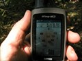
|  N 44 00.000 W 72 00.000- Piermont, NH N 44 00.000 W 72 00.000- Piermont, NH
in Confluence Spots One of 4 confluences in NH posted by: Mountain_Wanderer location: New Hampshire date approved: 08/10/2006 last visited: 04/27/2015 |
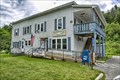 view gallery view galleryNW15.6 km |  Vershire, VT 05079 Vershire, VT 05079
in U.S. Post Offices Located on Vermont 113 posted by: nomadwillie location: Vermont date approved: 07/19/2017 last visited: never |
 view gallery view gallerySW15.9 km | Union Village Bridge in Covered Bridges This is the most beautiful (technically) bridge I have ever seen. It is a MUST SEE! The substructure consists of full lengthwise laminated beams. The builder kept the vintage look combined with the latest technology underneath. posted by: CoveredBridgeGuy location: Vermont date approved: 02/02/2007 last visited: never |
 view gallery view gallery E18.3 km E18.3 km
| X 34 RESET 1985 (NGS, Wentworth, NH) in U.S. Benchmarks A NGS vertical control mark, located in Wentworth, NH.
The NHDOT ID# is 475-0050. posted by: NH2beers location: New Hampshire date approved: 05/31/2012 last visited: never |
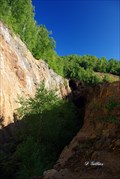 view gallery view gallerySW18.7 km |  Elizabeth Copper Mine Elizabeth Copper Mine
in Mines Abandoned open pit copper mine. posted by: DGillies location: Vermont date approved: 09/08/2009 last visited: never |
 view gallery view galleryE18.7 km | OC0943: W 34 1955 (USC&GS/NGS, Wentworth, NH) in U.S. Benchmarks A USC&GS standard bench mark disk, located in Wentworth, NH.
The NGS PID# is OC0943.
The NHDOT ID# is 475-0020. posted by: NH2beers location: New Hampshire date approved: 05/31/2012 last visited: never |
 view gallery view galleryE18.8 km | Friendship Bridge - Wentworth, NH in Covered Bridges A pedestrian covered bridge located in the center of Wentworth Village, New Hampshire. posted by: MonkeyAndTheEngineer location: New Hampshire date approved: 08/24/2019 last visited: 07/10/2022 |
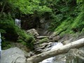 view gallery view galleryW18.8 km |  Old City Falls Old City Falls
in Waterfalls Beautiful local secret. Two tiered fall with a first drop of 25' and a second drop of 20'. posted by: rhythm112 location: Vermont date approved: 11/19/2007 last visited: never |
|