 view gallery view gallery NW20.8 km NW20.8 km
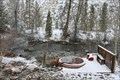
|   Bowery Hot Springs Bowery Hot Springs
in Hot Springs Bowery Hot Springs is just beyond the Bowery Guard Station along the East Fork of the Salmon River. posted by:  chuktA chuktA location: Idaho date approved: 10/04/2011 last visited: 03/05/2011 |
 view gallery view gallery S22.4 km S22.4 km
|  Ernest Hemingway - Ketchum, ID Ernest Hemingway - Ketchum, ID
in Grave of a Famous Person Grave of journalist, Pulitzer Prize-winning author and Nobel laureate in literature, Ernest Hemingway. posted by: hykesj location: Idaho date approved: 03/04/2023 last visited: never |
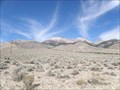
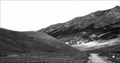
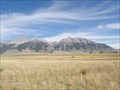 view gallery view gallery NE41.7 km NE41.7 km
|  Mount Borah View - Idaho Mount Borah View - Idaho
in Scenic Roadside Look-Outs View point and signs for Mount Borah and the Borah Peak Earthquake. posted by: Volcanoguy location: Idaho date approved: 07/27/2011 last visited: 05/17/2017 |
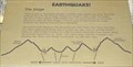
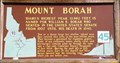 view gallery view galleryNE41.7 km |  #45 - Mount Borah #45 - Mount Borah
in Idaho Historical Markers Idaho History Sign #45 about Mount Borah. posted by: Volcanoguy location: Idaho date approved: 08/06/2011 last visited: 05/17/2017 |
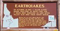 view gallery view galleryNE41.7 km | #356 - Earthquakes in Idaho Historical Markers Idaho History Sign #356 about the Borah Peak Earthquake. posted by: Volcanoguy location: Idaho date approved: 08/06/2011 last visited: 05/17/2017 |
 view gallery view gallery N41.8 km N41.8 km
|  Beaverhead Crater, Idaho Beaverhead Crater, Idaho
in Impact Craters Beaverhead Crater is an impact structure located in central Idaho around the Challis area. posted by: Rose Red location: Idaho date approved: 07/21/2007 last visited: never |
 view gallery view galleryNE42 km | Leatherman Peak View - Idaho in Scenic Roadside Look-Outs View point and sign for Leatherman Peak. posted by: Volcanoguy location: Idaho date approved: 07/26/2011 last visited: 09/24/2010 |
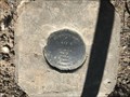
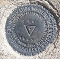 view gallery view gallery E43 km E43 km
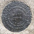
|  PZ0772 - USCGS SAW, Idaho PZ0772 - USCGS SAW, Idaho
in U.S. Benchmarks U.S. Coast & Geodetic Survey triangulation station SAW. posted by: Volcanoguy location: Idaho date approved: 07/26/2011 last visited: 09/24/2010 |
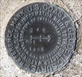 view gallery view galleryE43 km | PZ0772 - USCGS SAW NO 1, Idaho in U.S. Benchmarks U.S. Coast & Geodetic Survey reference mark SAW NO 1. posted by: Volcanoguy location: Idaho date approved: 07/27/2011 last visited: 09/24/2010 |
 view gallery view galleryE43 km | PZ0772 - USCGS SAW NO 2, Idaho in U.S. Benchmarks U.S. Coast & Geodetic Survey reference mark SAW NO 2. posted by: Volcanoguy location: Idaho date approved: 07/27/2011 last visited: 09/24/2010 |
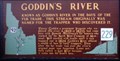 view gallery view galleryE43.6 km | Goddin's River in Idaho Historical Markers Known as Goddin's River in the days of the fur trade. This stream originally was named for the trapper who discovered it. posted by: muddawber location: Idaho date approved: 04/14/2007 last visited: 09/24/2010 |
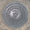 view gallery view galleryNE43.6 km | PZ0616 - USCGS DICKEY, Idaho in U.S. Benchmarks U.S. Coast & Geodetic Survey triangulation station DICKEY. posted by: Volcanoguy location: Idaho date approved: 07/27/2011 last visited: 09/24/2010 |
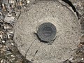
 view gallery view gallery SW45.4 km SW45.4 km
| Dollarhide Summit Benchmark in U.S. Benchmarks USGS Benchmark Disk located at the top of Dollarhide Summit, near Ketchum Idaho. posted by: 1450Crew location: Idaho date approved: 06/20/2009 last visited: never |
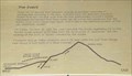 view gallery view galleryNE45.7 km | Earthquake! - The Event in Idaho Historical Markers One of a group of three signs on the Double Springs Pass Road. posted by: Volcanoguy location: Idaho date approved: 08/19/2011 last visited: 05/17/2017 |
 view gallery view galleryNE45.7 km |  Borah Peak Earthquake Scarps Borah Peak Earthquake Scarps
in Places of Geologic Significance Borah Peak Earthquake Scarps on Double Springs Pass Road. posted by: Volcanoguy location: Idaho date approved: 07/27/2011 last visited: 05/17/2017 |
 view gallery view galleryNE45.7 km | Earthquake! - The Results in Idaho Historical Markers One of a group of three signs on the Double Springs Pass Road. posted by: Volcanoguy location: Idaho date approved: 08/19/2011 last visited: 05/17/2017 |
 view gallery view galleryNE45.7 km | Earthquake! - The Stage in Idaho Historical Markers One of a group of three signs on the Double Springs Pass Road. posted by: Volcanoguy location: Idaho date approved: 08/21/2011 last visited: 05/17/2017 |
 view gallery view galleryNE46 km | PZ0458 - USCGS T15, Idaho in U.S. Benchmarks U.S. Coast & Geodetic Survey benchmark T15. posted by: Volcanoguy location: Idaho date approved: 07/27/2011 last visited: 09/24/2010 |
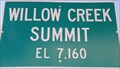 view gallery view galleryNE46 km |  7160 Ft - Willow Creek Summit - Idaho 7160 Ft - Willow Creek Summit - Idaho
in Elevation Signs Elevation sign at Willow Creek Summit. posted by: Volcanoguy location: Idaho date approved: 07/26/2011 last visited: 09/24/2010 |
 view gallery view galleryE47.2 km | KAY 2 NO 3 - Custer County, Idaho in U.S. Benchmarks Reference mark 3 for triangulation station KAY 2, located near Mackay Reservoir. posted by: Tom.dog location: Idaho date approved: 12/23/2022 last visited: never |
 view gallery view galleryE47.2 km | KAY NO 2 - Custer County, Idaho in U.S. Benchmarks Reference mark 2 for triangulation station KAY 2. posted by: Tom.dog location: Idaho date approved: 12/23/2022 last visited: never |
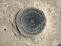 view gallery view galleryE47.2 km | KAY 2 (OY0985) - Custer County, Idaho in U.S. Benchmarks A triangulation station on the southwest side of U.S. Highway 93, near Mackay Reservoir. posted by: Tom.dog location: Idaho date approved: 12/23/2022 last visited: never |
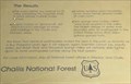
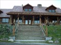 view gallery view galleryNW52.6 km |  Idaho Rocky Mountain Club - Stanley, ID Idaho Rocky Mountain Club - Stanley, ID
in U.S. National Register of Historic Places This is one of those historic locations that I love: not a dusty old building that has some remote relevance to the present, but a piece of living history that has relevance to present day travelers as it did nearly 80 years ago. posted by: Touchstone location: Idaho date approved: 06/24/2007 last visited: never |
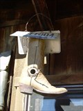 view gallery view galleryNW53.1 km |  The Boot-house The Boot-house
in Unique Bird Houses Located near the barn of the Idaho Rocky Mountain Ranch, this cowboy boot appears to have found a second life after, what I can imagine, a life full of adventure on some wranglers foot. posted by: Touchstone location: Idaho date approved: 06/25/2007 last visited: never |
 view gallery view galleryNW53.3 km | Idaho Rocky Mountain Ranch Hot Springs in Hot Springs A private hot spring fed pool associated with the nearby Idaho Rocky Mountain Ranch. posted by: Touchstone location: Idaho date approved: 06/25/2007 last visited: never |
|