 view gallery view gallery N0 km N0 km
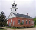
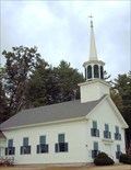
|   Campton Baptist Church - Campton, NH Campton Baptist Church - Campton, NH
in This Old Church This church is on Main St. in the main village of Campton, NH, and dates from 1826. posted by:  silverquill silverquill location: New Hampshire date approved: 04/27/2007 last visited: 04/12/2009 |
 view gallery view gallery SE0.2 km SE0.2 km
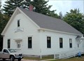
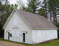
|  Elementary School/Town Hall - Campton, NH Elementary School/Town Hall - Campton, NH
in Former Schools This former elementary school became home for the town hall of the town of Campton, New Hampshire. posted by: silverquill location: New Hampshire date approved: 02/28/2008 last visited: 04/12/2009 |
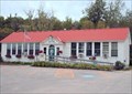 view gallery view gallerySE0.2 km |  Campton, NH Campton, NH
in City and Town Halls This former elementary school is now home to the town offices for the town of Campton, New Hampshire, chartered in 1761. posted by: silverquill location: New Hampshire date approved: 02/28/2008 last visited: 04/12/2009 |
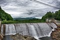 view gallery view gallerySE0.5 km |  Campton Dam - Campton, NH Campton Dam - Campton, NH
in Civilian Conservation Corps The present concrete dam is 20’ downstream from the original. This dam was built in 1935 by the Civilian Conservation Corps that also worked on extending Tripoli Road into Waterville Valley. posted by:  nomadwillie nomadwillie location: New Hampshire date approved: 05/04/2022 last visited: never |
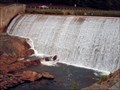 view gallery view gallerySE0.5 km |  Campton Falls Dam - Campton, NH Campton Falls Dam - Campton, NH
in Man-made Waterfalls A scenic site on the upper Merrimack River near the village of Campton, New Hampshire. It is also known as Campton Pond Dam. posted by: silverquill location: New Hampshire date approved: 03/17/2008 last visited: 05/23/2015 |
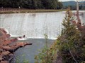 view gallery view gallerySE0.5 km |  Campton Pond Dam - Campton, NH Campton Pond Dam - Campton, NH
in Water Dams The Campton Pond Dam is located on the upper Merrimack River near the village of Campton, New Hampshire. posted by: silverquill location: New Hampshire date approved: 03/17/2008 last visited: 05/03/2022 |
 view gallery view gallery S1.4 km S1.4 km
|  Campton Public Library - Campton, NH Campton Public Library - Campton, NH
in Libraries This is a small library serving the historic community of Campton, New Hampshire, about 3,000 in population. posted by: silverquill location: New Hampshire date approved: 05/07/2007 last visited: 05/23/2015 |
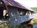
 view gallery view gallery SW2.3 km SW2.3 km
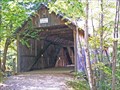
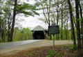
|  Turkey Jim Bridge Turkey Jim Bridge
in Covered Bridges A short Queen post trussed bridge hidden in the woods of a campground. It was once used a passage way from the highway to private property, but now used for snowmobiles mainly. posted by: CoveredBridgeGuy location: New Hampshire date approved: 12/25/2008 last visited: 11/07/2010 |
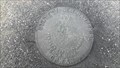
 view gallery view gallery NW3.7 km NW3.7 km
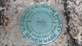
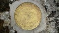
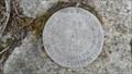
|  OC1009: P 5 (USC&GS/NGS, Thornton, NH) OC1009: P 5 (USC&GS/NGS, Thornton, NH)
in U.S. Benchmarks A USC&GS standard bench mark disk, located in Thornton, NH.
The NGS PID# is OC1009.
The NHDOT ID# is 449-0070. posted by: NH2beers location: New Hampshire date approved: 05/17/2011 last visited: never |
 view gallery view gallery NE3.9 km NE3.9 km
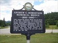
|  Andrew C. Robertson Memorial Bridge Andrew C. Robertson Memorial Bridge
in New Hampshire Historical Markers A historical marker in the Thornton, New Hampshire about Andrew C. Robertson. The nearby memorial bridge in his name is crossing the Mad River at this site. posted by: king.hubi location: New Hampshire date approved: 07/24/2010 last visited: 05/23/2015 |
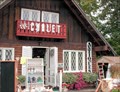 view gallery view galleryS4.7 km |  Chalet Antiques - Campton, NH Chalet Antiques - Campton, NH
in Antique Shops Two floors of antiques ranging from vintage jewelry, depression glass and Delft pottery, and tapestries and rugs - located in Campton, New Hampshire. posted by: silverquill location: New Hampshire date approved: 03/09/2008 last visited: 05/23/2015 |
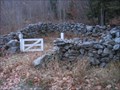 view gallery view gallerySW5.3 km |  Town Pound, Campton, NH Town Pound, Campton, NH
in Town and Village Pounds The Town Pound in Campton, NH. posted by: Too Tall John location: New Hampshire date approved: 11/08/2010 last visited: 12/26/2011 |
 view gallery view galleryS5.3 km |  Campton Historical Society - Campton, NH Campton Historical Society - Campton, NH
in Historical Society Headquarters This small community in central New Hampshire is perhaps best known for the nearby Blair Covered Bridge. posted by: silverquill location: New Hampshire date approved: 07/22/2010 last visited: 05/23/2015 |
 view gallery view galleryS5.3 km |  Campton Historical Society Museum - Campton, NH Campton Historical Society Museum - Campton, NH
in History Museums This small community in central New Hampshire is perhaps best known for the nearby Blair Covered Bridge. This former town hall and library now serves as the museum and headquarters for the local historical society. posted by: silverquill location: New Hampshire date approved: 07/22/2010 last visited: 05/23/2015 |
 view gallery view galleryS5.6 km | Campton Congregational Church - Campton, NH in This Old Church Dating from 1774, this church is a local attraction, but is home to an active congregation. posted by: silverquill location: New Hampshire date approved: 04/27/2007 last visited: 05/23/2015 |
 view gallery view galleryS5.6 km | Bump Bridge in Covered Bridges Until 2008, this bridge rested on timber bents. In September of 2008 we visited the bridge and saw a Graton employee working on the replacement of the timber bents with concrete abutments. posted by: CoveredBridgeGuy location: New Hampshire date approved: 12/21/2008 last visited: 11/07/2010 |
 view gallery view galleryNW5.8 km | Thornton, NH in City and Town Halls Town Hall, Thornton, NH posted by: silverquill location: New Hampshire date approved: 05/21/2006 last visited: 04/25/2009 |
 view gallery view galleryNE5.8 km | 449 0100 (NHDPW&H, Thornton, NH) in U.S. Benchmarks A NHDPW&H standard bench mark disk, located in Thornton, NH, in the White Mountain National Forest.
The NHDOT ID# is 449-0100. posted by: NH2beers location: New Hampshire date approved: 05/17/2011 last visited: 05/19/2015 |
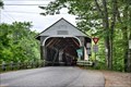
 view gallery view galleryS6.4 km |  Blair Bridge - River Heritage Trail - Campton, NH Blair Bridge - River Heritage Trail - Campton, NH
in National Scenic Byways The Blair Bridge is a wooden covered bridge originally built in 1829, that crosses the Pemigewasset River near Campton, New Hampshire, United States. It connects New Hampshire Route 175 to the east and U.S. Route 3 and Interstate 93 to the west. posted by: nomadwillie location: New Hampshire date approved: 05/04/2022 last visited: 10/16/2023 |
 view gallery view galleryS6.4 km |  Blair Bridge - Campton, NH Blair Bridge - Campton, NH
in Truss Bridges According to the NH Marker "The bridge employs a truss design patented by Col. Stephen Harriman Long." posted by: nomadwillie location: New Hampshire date approved: 05/03/2022 last visited: 10/16/2023 |
 view gallery view galleryS6.4 km |  Blair Bridge (New Hampshire) Blair Bridge (New Hampshire)
in Wikipedia Entries The first bridge at this location was built in 1829. This bridge was built in 1869 posted by: nomadwillie location: New Hampshire date approved: 05/03/2022 last visited: 10/16/2023 |
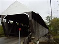 view gallery view galleryS6.4 km | Blair Bridge, Campton, NH in Covered Bridges Hiram W. Merrill (1822-1898) of Plymouth, N. H., built this bridge in 1870 to replace a span of 1829 that had been burned by an arsonist. The bridge employs a truss design patented by Col. Stephen Harriman Long (1784-1864) of Hopkinton, N. H. It is New Hampshire’s only surviving example of Long’s patent to retain wedges at the lower chords by which the trusses were pre-stressed during construction, stiffening the bridge against the weight of traffic. Covered bridge expert Milton S. Graton (1908- posted by: silverquill location: New Hampshire date approved: 05/14/2006 last visited: 10/16/2023 |
 view gallery view galleryS6.4 km | Blair Bridge in New Hampshire Historical Markers BLAIR BRIDGE
Hiram W. Merrill (1822-1898) of Plymouth, N. H., built this bridge in 1870 to replace a span of 1829 that had been burned by an arsonist. The bridge employs a truss design patented by Col. Stephen Harriman Long (1784-1864) of Hopkinton, N. H. It is New Hampshire’s only surviving example of Long’s patent to retain wedges at the lower chords by which the trusses were pre-stressed during construction, stiffening the bridge against the weight of traffic. Covered bridge expert Milton posted by: silverquill location: New Hampshire date approved: 05/14/2006 last visited: 10/16/2023 |
 view gallery view galleryNE9.5 km | C 36 1927 (USGS, Waterville Valley, NH) in U.S. Benchmarks A USGS standard bench mark disk, located in Waterville Valley, NH.
The NHDOT ID# is 469-0030. posted by: NH2beers location: New Hampshire date approved: 05/17/2011 last visited: never |
 view gallery view galleryNE10 km | 469 0100 (NHDOT, Waterville Valley, NH) in U.S. Benchmarks A NHDOT standard survey disk, located in Waterville Valley, NH.
The NHDOT ID# is 469-0100. posted by: NH2beers location: New Hampshire date approved: 05/17/2011 last visited: never |
|