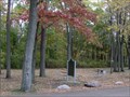
 view gallery view gallery N7.4 km N7.4 km
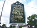
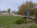
|   Great Fire of 1881 Great Fire of 1881
in Michigan Historical Markers Located in the Brown Roadside Park honoring Henry A. Hamp, on the east side of M-25 about 1/2 mile south of the Pigeon Road(M-142) intersection. I'll let you figure out parking. posted by:  S5280ft S5280ft location: Michigan date approved: 10/17/2006 last visited: 09/02/2016 |
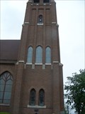
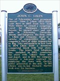 view gallery view gallery W7.6 km W7.6 km
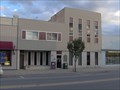
| John C. Liken / John C. Martini House in Michigan Historical Markers Located at 644 E. Main Street in the town of Sebewaing, MI. posted by: Team--B location: Michigan date approved: 11/03/2012 last visited: 09/02/2016 |
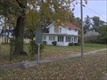
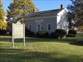 view gallery view gallery SW7.6 km SW7.6 km
| The Indian Mission in Michigan Historical Markers Located on the south side of East Bay Street about 0.2 miles east of M-25 (Unionville Road/Beck Street). Parking available at the school. posted by: S5280ft location: Michigan date approved: 10/17/2006 last visited: 06/05/2016 |
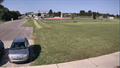
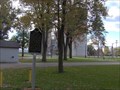 view gallery view gallery E7.9 km E7.9 km
| Owendale in Michigan Historical Markers Located in a village park on the south side of Main Street between 2nd and 3rd Streets. Plentiful parking at the PARK! posted by: S5280ft location: Michigan date approved: 10/17/2006 last visited: 06/05/2016 |
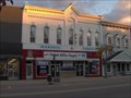
 view gallery view galleryW8 km | Sebewaing Township Hall in Michigan Historical Markers On Center / Grove St. Parking lot for the Hall, really easy to find. posted by:  Historic Markers Historic Markers location: Michigan date approved: 06/06/2016 last visited: 10/06/2016 |
 view gallery view galleryW8 km | Gagetown in Michigan Historical Markers St Agathas Church in Gagetown, a lot of parking there posted by: Historic Markers location: Michigan date approved: 06/06/2016 last visited: 10/06/2016 |
 view gallery view galleryN10.6 km | Stagecoaches in Michigan Historical Markers Located on the north side of Cedar Street, just east of 2nd Street. posted by: S5280ft location: Michigan date approved: 10/17/2006 last visited: 06/05/2016 |
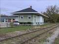 view gallery view gallery NE10.6 km NE10.6 km
| Pigeon Depot in Michigan Historical Markers Located on the east side of Main Street (Pigeon Road/M-142), between Michigan Avenue and the railroad tracks. Plentiful parking at the depot. posted by: S5280ft location: Michigan date approved: 10/17/2006 last visited: 06/05/2016 |
 view gallery view galleryN10.8 km | Bay Port Fishing District in Michigan Historical Markers Located in the boat launch off of Promenade [Street] north of Main Street (M-25). Plentiful parking at the boat launch. posted by: S5280ft location: Michigan date approved: 10/17/2006 last visited: 06/05/2016 |
 view gallery view galleryNE12.2 km |  Pigeon, MI Pigeon, MI
in Web Cameras Webcam placed at Laker Schools in Pigeon, Michigan. posted by: bobfrapples8 location: Michigan date approved: 10/08/2023 last visited: never |
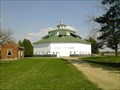 view gallery view gallery SE14.6 km SE14.6 km
|  Thumb Octagon Barn Thumb Octagon Barn
in Octagon Buildings An old Octagon barn used as a museum of times past. posted by: Team Us location: Michigan date approved: 09/24/2005 last visited: 03/11/2010 |
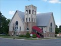
![Image for Methodist Episcopal Church [of Caseville]](https://img.geocaching.com/waymarking/small/0efd40db-72a0-4dd4-9b51-24ed3a7f6e09.jpg) view gallery view galleryN22 km | Methodist Episcopal Church [of Caseville] in Michigan Historical Markers Located on the northwest corner of Riverside Drive and Main Street (M-25). Plentiful parking at the church. posted by: S5280ft location: Michigan date approved: 10/17/2006 last visited: 06/05/2016 |
 view gallery view gallerySE22.5 km | Elkland Township Hall in Michigan Historical Markers Located on the north side of Main Street between West and Leach Streets. Streetside parking available. posted by: S5280ft location: Michigan date approved: 10/17/2006 last visited: 01/07/2014 |
 view gallery view gallerySE22.5 km | First Presbyterian Church (Cass City) in Michigan Historical Markers First Presbyterian Church in Cass City, sits in a quiet town. There is a parking lot diagonal from the church with prime parking and picture opportunities. posted by: Historic Markers location: Michigan date approved: 01/08/2014 last visited: 01/08/2014 |
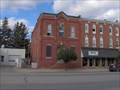
 view gallery view gallerySE22.7 km |  Hello Mr. Chips - Cass City, Michigan Hello Mr. Chips - Cass City, Michigan
in Neon Signs A corner gas station in Cass City with an interesting name. And some great indoor neon. posted by: S5280ft location: Michigan date approved: 11/28/2007 last visited: never |
 view gallery view gallerySE23.7 km | State Reward Road No. 1 in Michigan Historical Markers A nice little roadside park just east of Cass City. posted by: Historic Markers location: Michigan date approved: 01/08/2014 last visited: 01/08/2014 |
 view gallery view galleryNE24.5 km |  Giant Corn Maze Giant Corn Maze
in Outdoor Mazes Get Lost on Depner Farms Giant Corn Maze! posted by: LucyLee location: Michigan date approved: 09/08/2005 last visited: 05/24/2013 |
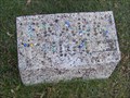 view gallery view gallerySW27.2 km |  Frank Thum - Wisner Cemetery Frank Thum - Wisner Cemetery
in Homemade Tombstones Marbles (not marble) spelling out a name set in concrete. posted by: S5280ft location: Michigan date approved: 10/28/2007 last visited: 06/04/2016 |
 view gallery view gallerySW27.2 km | Indian Dave in Michigan Historical Markers Located at the entrance to Wisner Cemetery, on the north side of Bay City-Forrestville Road, between Bradleyville and Garner Roads. Plentiful parking at the cemetery, or the nearby township office. posted by: S5280ft location: Michigan date approved: 10/17/2006 last visited: 09/02/2016 |
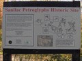 view gallery view galleryE29.1 km |  Sanilac Petroglyphs Historic Site Sanilac Petroglyphs Historic Site
in Pictographs The Sanilac Petroglyphs historic site is located near Bad Axe. Take M-53 then turn east on Bay City-Forestville Road to Germania Road. Head south 1/2 mile on Germania; the site is on the west side of the road. Parking is at N43 39.404, W083 01.097. posted by: S5280ft location: Michigan date approved: 12/15/2006 last visited: never |
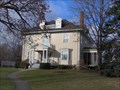 view gallery view gallery S29.6 km S29.6 km
| William H. Carson House in Michigan Historical Markers Located on the north side of Burnside Street, west of Fremont Street. Streetside parking available. posted by: S5280ft location: Michigan date approved: 12/05/2006 last visited: 01/12/2015 |
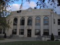 view gallery view galleryS29.6 km | Tuscola County Courthouse in Michigan Historical Markers Located on the east corner of East Sherman and North State Streets. Plentiful street parking available. posted by: S5280ft location: Michigan date approved: 10/17/2006 last visited: 01/18/2021 |
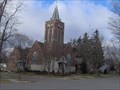 view gallery view galleryS29.6 km | First Presbyterian Church of Caro in Michigan Historical Markers Located on the northwest corner of West Lincoln and North Almer Streets. Plentiful parking at the church. posted by: S5280ft location: Michigan date approved: 10/17/2006 last visited: 01/12/2015 |
 view gallery view galleryS29.6 km | Tuscola County Advertiser in Michigan Historical Markers Located on the southeast side of North State Street between Sherman and Burnside Streets. Street parking available. posted by: S5280ft location: Michigan date approved: 10/17/2006 last visited: 09/27/2019 |
 view gallery view galleryS29.8 km | Caro Masonic Temple in Michigan Historical Markers Located on the southeast side of North State Street (M-81)between Frank and Lincoln Streets. Streetside parking available. LOOK ABOVE THE DOOR. posted by: S5280ft location: Michigan date approved: 10/17/2006 last visited: 01/18/2021 |
|