 view gallery view gallery NW0.2 km NW0.2 km
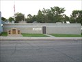
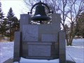
|   "American Legion Post 23", Garretson, South Dakota "American Legion Post 23", Garretson, South Dakota
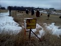
in Legion Posts and Branches Post named for Henry G. Fix, the son of Mr. and Mrs. Oliver Fix. He was killed in action by a snipers bullet in France in the summer of 1918. posted by:  NGComets NGComets location: South Dakota date approved: 08/16/2010 last visited: 02/05/2012 |
 view gallery view gallery N0.2 km N0.2 km
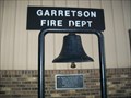
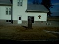
|  Bell, Fire Department, Garretson, South Dakota Bell, Fire Department, Garretson, South Dakota
in Bells Retired fire department bell. posted by: NGComets location: South Dakota date approved: 08/16/2010 last visited: 02/05/2012 |
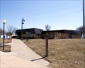
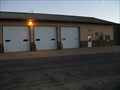 view gallery view galleryN0.2 km |  Garretson Fire Dept. Garretson Fire Dept.
in Firehouses Small town fire department. posted by: NGComets location: South Dakota date approved: 08/18/2010 last visited: 04/12/2011 |
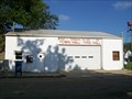
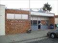 view gallery view galleryN0.3 km |  Garretson, South Dakota 57030 Garretson, South Dakota 57030
in U.S. Post Offices Small town post office. posted by: NGComets location: South Dakota date approved: 08/16/2010 last visited: 02/05/2012 |
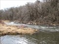
 view gallery view galleryN0.5 km |  Garretson Garretson
in South Dakota Historical Markers In the 1870's the town of Garretson was started by people coming in and starting the now vanished village of Palisades. The Village of Palisades was situated high above Split Rock Creek where a flour mill was started by CW Patton. posted by: MNSearchers location: South Dakota date approved: 04/17/2006 last visited: 08/15/2013 |
 view gallery view gallery NE1 km NE1 km
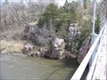
| Devil's Gulch in South Dakota Historical Markers Where Jesse James was able to escape the law after robbing a bank in Northfield, MN. posted by:  GPX Navigators GPX Navigators location: South Dakota date approved: 05/04/2006 last visited: 07/22/2012 |
 view gallery view gallery W2.6 km W2.6 km
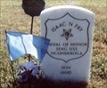
|  Isaac N. Fry-Garretson, SD Isaac N. Fry-Garretson, SD
in Medal Of Honor Resting Places Civil War Medal of Honor Recipient for action on board the USS Ticonderoga during the attacks on Fort Fisher January 13-15, 1865. He is buried in Summit Hill Cemetery, Garretson, SD in Block 1, Lot 2, Row 8, Grave 5. posted by: Don.Morfe location: South Dakota date approved: 08/25/2018 last visited: 12/09/2021 |
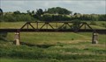
 view gallery view gallery SW3.1 km SW3.1 km
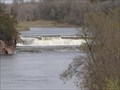
| 1908 Palisades Bridge in South Dakota Historical Markers In 1908 the Western Bridge and Construction Company of Omaha Nebraska built this Pratt Through-Truss Bridge. posted by: MNSearchers location: South Dakota date approved: 04/17/2006 last visited: 03/24/2020 |
 view gallery view gallerySW3.4 km | Village of Pallisades in South Dakota Historical Markers Settlers homesteaded in this area beginning in 1865. posted by: GPX Navigators location: South Dakota date approved: 07/04/2006 last visited: 05/07/2015 |
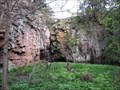
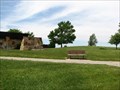
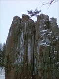 view gallery view gallerySW3.4 km |  King and Queen at Palisades State Park King and Queen at Palisades State Park
in Established Rock Climbing Areas Within the Palisades State Park, near Garretson, SD, are two spires known as the King and Queen. There are also other cliffs that make for a great climb, technical or otherwise. posted by: beta59 location: South Dakota date approved: 04/16/2011 last visited: 06/04/2018 |
 view gallery view gallery S4.5 km S4.5 km
|  Cattle Crossing - Brandon, SD Cattle Crossing - Brandon, SD
in Uncommon Crossing Signs A sign warning travelers of pending bovine confrontations right in front of some artful cows. posted by: beta59 location: South Dakota date approved: 02/10/2012 last visited: 06/10/2012 |
 view gallery view galleryNE5.3 km | Town Hall - Fire Hall in Firehouses Fire department in Sherman, SD. posted by: NGComets location: South Dakota date approved: 08/18/2010 last visited: 06/24/2012 |
 view gallery view galleryW7.2 km | Bell - Norway Lutheran Church Bell - Sherman, SD in Bells An historic bell in a country cemetery near Sherman and Garretson, South Dakota. posted by: beta59 location: South Dakota date approved: 12/29/2010 last visited: 02/18/2012 |
 view gallery view gallerySW8.7 km |  Split Rock Lutheran Church - Brandon, SD Split Rock Lutheran Church - Brandon, SD
in Lutheran Churches Split Rock Lutheran Church in rural Brandon, SD posted by: beta59 location: South Dakota date approved: 05/22/2012 last visited: 04/06/2019 |
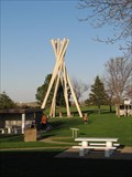
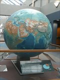 view gallery view galleryW10.3 km |  EROS Globe - Sioux Falls SD EROS Globe - Sioux Falls SD
in Earth Globes This globe is in the lobby of the Earth Resources Observation and Science (EROS) Center 15 miles north of Sioux Falls SD. posted by: PeterNoG location: South Dakota date approved: 07/25/2010 last visited: 04/13/2009 |
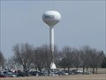 view gallery view galleryW10.3 km |  EROS Water Tower - Sioux Falls SD EROS Water Tower - Sioux Falls SD
in Water Towers This water tower is at the Earth Resources Observation and Science (EROS) Center 15 miles north of Sioux Falls SD. posted by: PeterNoG location: South Dakota date approved: 12/08/2009 last visited: 04/12/2011 |
 view gallery view gallerySW10.9 km |  Split Rock Creek Pratt Through Truss Bridge -- nr Corson SD Split Rock Creek Pratt Through Truss Bridge -- nr Corson SD
in Truss Bridges A gorgeous stone and iron truss bridge along SD 11 near Corson SD posted by: Benchmark Blasterz location: South Dakota date approved: 12/16/2013 last visited: 07/30/2013 |
 view gallery view galleryS12.1 km | Minnehaha County in South Dakota Historical Markers Description & History of Minnehaha County, SD posted by: GPX Navigators location: South Dakota date approved: 05/11/2006 last visited: 08/30/2022 |
 view gallery view galleryS12.2 km |  South Dakota/Minnesota Border Crossing on I-90 South Dakota/Minnesota Border Crossing on I-90
in Border Crossings This border crossing is located on I-90 a few miles east of Sioux Falls, South Dakota. Minnesota has a nice rest area with a trail leading to the sign so you can take your picture with it. posted by: Hikenutty location: Minnesota date approved: 07/26/2007 last visited: 06/03/2016 |
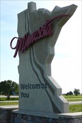
 view gallery view galleryS12.4 km |  Welcome to Minnesota Welcome to Minnesota
in Minnesota Historical Markers Known to her citizens as the North Star State or the Gopher State. posted by: GPX Navigators location: South Dakota date approved: 05/29/2006 last visited: 08/30/2022 |
 view gallery view galleryS12.4 km | Sioux Quartzite and Pipestone in Minnesota Historical Markers Rich farmland in SW Minnesota has large outcroppings of a hard red-to-pink rock known as Sioux Quartzite. Within the quartzite deposits are smaller layers of dark red stone known as pipestone. posted by: GPX Navigators location: South Dakota date approved: 05/29/2006 last visited: 08/30/2022 |
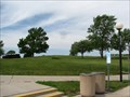
 view gallery view galleryS12.4 km |  Beaver Creek Rest Area - SD. Beaver Creek Rest Area - SD.
in Highway Rest Areas This rest area is located 0.5 miles west of the Minnesota/South Dakota boarder on eastbound I-90. posted by: Siren Hunter location: South Dakota date approved: 04/05/2011 last visited: 08/30/2022 |
 view gallery view galleryS12.4 km |  Beaver Creek Travel Information Center - SD Beaver Creek Travel Information Center - SD
in Tourist Information Centers - Visitor Centers The Beaver Creek Travel Information Center is located 0.5 miles west of the Minnesota/South Dakota line on eastbound I-90. posted by: Siren Hunter location: South Dakota date approved: 04/02/2011 last visited: 08/30/2022 |
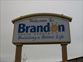 view gallery view gallerySW13.4 km |  Welcome to Brandon, South Dakota Welcome to Brandon, South Dakota
in Welcome Signs Sign is located on the north edge of town, just south of Interstate 90 on SD Highway 11.
Elevation 1360 posted by: NGComets location: South Dakota date approved: 05/23/2013 last visited: 02/10/2019 |
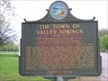 view gallery view galleryS14.2 km | The Town of Valley Springs in South Dakota Historical Markers This area was officially opened to the Homesteaders Act in 1868 of which New England and Scandinavian Immigrants followed schooner trails into this Minnesota Territory Valley to settle. posted by: MNSearchers location: South Dakota date approved: 04/29/2006 last visited: 07/10/2019 |
|