 view gallery view gallery W1.3 km W1.3 km
|   Lil Chef - Midland, MI Lil Chef - Midland, MI
in Neon Signs Open 24 hours. A rarity in these parts. posted by:  Team Farkle 7 Team Farkle 7 location: Michigan date approved: 10/19/2009 last visited: never |
 view gallery view gallery NW2.6 km NW2.6 km
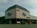
|  Kroger - Ashman Street, Midland, Michigan, USA Kroger - Ashman Street, Midland, Michigan, USA
in Kroger Supermarkets This Kroger store is not too far out of the centre of Midland. posted by:  Superted Superted location: Michigan date approved: 04/14/2010 last visited: 09/01/2020 |
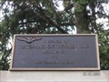 view gallery view galleryW3.7 km |  Midland County WWI Veterans Memorial Midland County WWI Veterans Memorial
in World War I Memorials and Monuments Midland County WWI Veterans Memorial. posted by: NickTnReb location: Michigan date approved: 07/01/2008 last visited: 02/09/2020 |
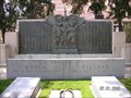 view gallery view galleryW3.7 km |  Midland County WWII Veterans Memorial Midland County WWII Veterans Memorial
in World War II Memorials / Monuments Midland County WWII Memorial. posted by: NickTnReb location: Michigan date approved: 07/01/2008 last visited: 02/09/2020 |
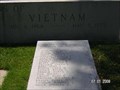 view gallery view galleryW3.7 km |  Vietnam War Memorial, Midland County Courthouse Grounds, Midland, MI, USA Vietnam War Memorial, Midland County Courthouse Grounds, Midland, MI, USA
in Vietnam War Memorials Midland County Vietnam Veterans Memorial. posted by: NickTnReb location: Michigan date approved: 07/03/2008 last visited: 02/09/2020 |
 view gallery view galleryW3.7 km |  Midland Country Korean War Veterans Memorial Midland Country Korean War Veterans Memorial
in Korean War Memorials Midland County Korean War Veterans Memorial. posted by: NickTnReb location: Michigan date approved: 07/01/2008 last visited: 02/09/2020 |
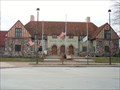 view gallery view galleryW3.9 km |  Midland County Courthouse Midland County Courthouse
in Michigan Historical Markers Located on the southwest side of Main Street, where Fitzhugh dead-ends in to Main. Streetside parking available. posted by: S5280ft location: Michigan date approved: 01/14/2007 last visited: 02/09/2020 |
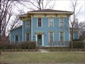 view gallery view galleryW4 km | John and Almira Kelly House in Michigan Historical Markers A private residence located on the southwest side of Main Street, between Hubbard and Ripley Streets. Parking is available on Ripley Street. posted by: S5280ft location: Michigan date approved: 01/14/2007 last visited: 02/09/2020 |
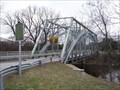 view gallery view galleryW4.2 km | The Upper Bridge in Michigan Historical Markers Located on the northeast end of the Currie Parkway crossing of the Tittabawassee River. Good luck on parking. posted by: S5280ft location: Michigan date approved: 01/14/2007 last visited: 02/09/2020 |
 view gallery view galleryW4.5 km |  Dow, Alden B., House and Studio - Midland MI Dow, Alden B., House and Studio - Midland MI
in U.S. National Register of Historic Places Alden B. Dow Home & Studio, in Midland, Michigan, was the house and studio that were the residence and acknowledged masterpiece of 20th century architect Alden B. Dow. posted by: nomadwillie location: Michigan date approved: 10/24/2015 last visited: 02/09/2020 |
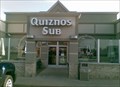 view gallery view galleryNW4.8 km |  Quiznos - Wackerly Square, Midland, MI Quiznos - Wackerly Square, Midland, MI
in Quiznos A small Quiznos in Wackerly Square in the north of Midland, just off US 10. posted by: Superted location: Michigan date approved: 06/21/2013 last visited: 01/13/2021 |
 view gallery view galleryNW5.8 km |  Midland Mall Taco Bell - Midland, Michigan, USA Midland Mall Taco Bell - Midland, Michigan, USA
in Taco Bell Restaurants A small Toco Bell store in the Midland Mall, Michigan. posted by: Superted location: Michigan date approved: 05/03/2010 last visited: 04/28/2017 |
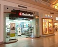 view gallery view galleryNW5.8 km |  Radio Shack - Midland Mall, Midland, Michigan, USA Radio Shack - Midland Mall, Midland, Michigan, USA
in Radio Shack Stores A small Radio Shack store in the Midland Mall in Michigan. posted by: Superted location: Michigan date approved: 05/03/2010 last visited: 03/04/2017 |
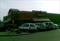 view gallery view galleryNW6.1 km |  Applebee's - Eastman Ave - Midland, MI Applebee's - Eastman Ave - Midland, MI
in Applebee's Restaurants A fair sized and usually busy Applebee's restaurant on Eastman Ave to the north of Midland, just off US 10. posted by: Superted location: Michigan date approved: 06/25/2013 last visited: 06/05/2016 |
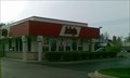 view gallery view galleryNW6.4 km |  Arby's - Eastman Ave - Midland - MI Arby's - Eastman Ave - Midland - MI
in Arby's Restaurants An Arby's on Eastman Ave in the north of Midland, just off US 10. posted by: Superted location: Michigan date approved: 07/14/2013 last visited: 04/28/2017 |
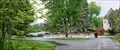
 view gallery view galleryW6.6 km |  Chippewa Nature Center "You Are Here Maps" #1 Chippewa Nature Center "You Are Here Maps" #1
in 'You Are Here' Maps One of several "You Are Here Maps" along the trails of the Chippewa Nature Center. posted by: NickTnReb location: Michigan date approved: 07/01/2008 last visited: 03/04/2017 |
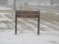 view gallery view gallery E7.4 km E7.4 km
|  Pine Grove Cemetery Williamston Twp. Auburn Mi, Pine Grove Cemetery Williamston Twp. Auburn Mi,
in Worldwide Cemeteries Pine Grove Cemetery posted by: just for the fun location: Michigan date approved: 04/18/2020 last visited: 04/18/2020 |
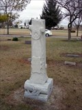 view gallery view galleryE7.4 km | Pine Grove Cemetery in Michigan Historical Markers Located on the northwest corner of 11 Mile Road and North Union Road. Parking available. posted by: S5280ft location: Michigan date approved: 01/14/2007 last visited: 02/09/2020 |
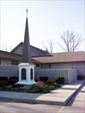 view gallery view gallery SE11.9 km SE11.9 km
| Freeland United Methodist Church in Michigan Historical Markers The marker is missing, and there is a new church built in 2000, but the steeple has been preserved. It is located on Freeland Road, between Smith and Second Streets. Parking is available. posted by: S5280ft location: Michigan date approved: 05/03/2007 last visited: 06/04/2016 |
 view gallery view galleryNW15.1 km |  Smokey Bear - Sanford, MI Smokey Bear - Sanford, MI
in Smokey Bear Sign Sightings Found Smokey Bear in front of the Department of Natural Resources Field Office. posted by: Team Farkle 7 location: Michigan date approved: 10/19/2009 last visited: 05/11/2017 |
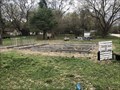 view gallery view galleryNW16.1 km |  "Sanford Grows" Community Garden - Sanford, MI "Sanford Grows" Community Garden - Sanford, MI
in Community Gardens Community Garden in Sanford posted by: stinger503 location: Michigan date approved: 04/22/2023 last visited: never |
 view gallery view galleryNW16.1 km |  Sanford Dam Disaster Memorial - Sanford, MI Sanford Dam Disaster Memorial - Sanford, MI
in Disaster Memorials Sanford Strong memorial for the Sanford Dam disaster posted by: stinger503 location: Michigan date approved: 04/22/2023 last visited: 04/23/2023 |
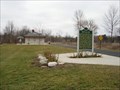 view gallery view galleryNW16.1 km | Origins of the Salt Industry/State Salt Well No. 1 in Michigan Historical Markers Located at the Sanford Trailhead on the Pere Marquette Rail-Trail. Take Maple Street southwest off of Saginaw Street. There is parking and a restroom. Or you can park along the 30 mile rail-trail and bike in. posted by: S5280ft location: Michigan date approved: 01/14/2007 last visited: 05/11/2017 |
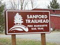 view gallery view galleryNW16.3 km |  Pere Marquette Rail-Trail, Sanford Trailhead Pere Marquette Rail-Trail, Sanford Trailhead
in Rails to Trails To get to the Sanford Trailhead, take Maple Street southwest off of Saginaw Street. There is parking and a restroom. posted by: S5280ft location: Michigan date approved: 01/14/2007 last visited: 09/23/2019 |
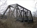 view gallery view galleryNW16.4 km |  Pere Marquette Rail-Trail bridge, Sanford, MI Pere Marquette Rail-Trail bridge, Sanford, MI
in Orphaned Bridges The bridge is located over the Tittabawassee River along the former Pere Marquette Railway. Parking is available at the Sanford trailhead on Maple Street, off of Saginaw Road. The bridge is 0.25 miles northwest. posted by: S5280ft location: Michigan date approved: 01/14/2007 last visited: 05/11/2017 |
|