 view gallery view gallery NE21.1 km NE21.1 km
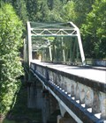
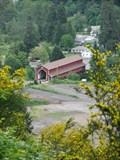
|   Judge Charles Barnard Bridge near Westfir, Oregon Judge Charles Barnard Bridge near Westfir, Oregon
in Truss Bridges This bridge is dedicated to Charles Barnard, Lane County judge from 1921-1932. posted by:  Queens Blessing Queens Blessing location: Oregon date approved: 08/22/2009 last visited: 09/15/2012 |
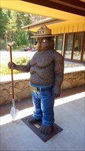 view gallery view galleryNE21.2 km |  Smokey Bear Statue at Middle Fork Ranger Station - Westfir, OR Smokey Bear Statue at Middle Fork Ranger Station - Westfir, OR
in Smokey Bear Sign Sightings Smokey Bear was spotted at the Middle Fork Ranger Station! posted by: NW_history_buff location: Oregon date approved: 05/02/2018 last visited: never |
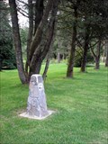
 view gallery view galleryNE21.2 km |  Free Emigrant Road - Westfir, Oregon Free Emigrant Road - Westfir, Oregon
in Wagon Roads and Trails The Free Emigrant Road crossed the desert of Eastern Oregon and passed over the Cascades and down the Willamette River to reach the fertile lands of the Willamette Valley posted by: TheBeanTeam location: Oregon date approved: 07/11/2007 last visited: 12/13/2014 |
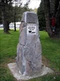 view gallery view galleryNE21.2 km |  Free Emigrant Road Free Emigrant Road
in Oregon Historical Markers Simple monument located at the Oakridge Ranger District offices on Highway 58. posted by: TheBeanTeam location: Oregon date approved: 05/07/2007 last visited: 04/20/2018 |
 view gallery view galleryNE21.2 km |  Free Emigrant Road - Westfir, Oregon - USA Free Emigrant Road - Westfir, Oregon - USA
in Human Migration Monuments The Free Emigrant Road was primarily used in 1853-54 with 2500 pioneers passing by. Known also as The Elliot Cutoff for one of the first trains to attempt its passing it became famous as the route of the "Lost Wagon Train" posted by: TheBeanTeam location: Oregon date approved: 10/07/2013 last visited: 04/20/2018 |
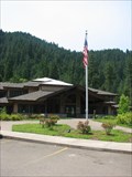 view gallery view galleryNE21.2 km |  Middle Fork Ranger Station - Willamette National Forest Middle Fork Ranger Station - Willamette National Forest
in Ranger Stations Ranger Station near Oakridge Oregon.
posted by: TheBeanTeam location: Oregon date approved: 07/24/2008 last visited: 12/12/2014 |
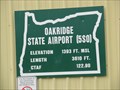 view gallery view galleryNE22 km |  Oakridge, OR State Airport - 1393' Oakridge, OR State Airport - 1393'
in Elevation Signs The sign is at the Oakridge State Airport west of Oakridge, Oregon. posted by: WR7X location: Oregon date approved: 05/11/2014 last visited: never |
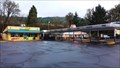
 view gallery view galleryNE22 km |  McDonalds ~ Oakridge, Oregon McDonalds ~ Oakridge, Oregon
in McDonald's Restaurants This McDonald's is located at 47567 Highway 58 in Oakridge, Oregon. posted by: brwhiz location: Oregon date approved: 12/31/2012 last visited: 11/09/2014 |
 view gallery view galleryNE22.2 km |  McDonalds Free WiFi ~ Oakridge, Oregon McDonalds Free WiFi ~ Oakridge, Oregon
in Wi-Fi Hotspots Free WiFi Served Daily at the McDonalds located at 47567 Highway 58 in Oakridge, Oregon. posted by: brwhiz location: Oregon date approved: 12/23/2012 last visited: never |
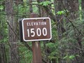 view gallery view galleryNE22.4 km | Hills Creek Dam (West Side) - Oakridge, OR - 1500' in Elevation Signs The 1500' contour is marked along FS Road 21 near the west end of Hills Creek Dam. posted by: WR7X location: Oregon date approved: 05/18/2014 last visited: never |
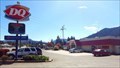 view gallery view galleryNE22.4 km |  Dairy Queen #6198 - Oakridge, OR Dairy Queen #6198 - Oakridge, OR
in Dairy Queen Restaurants A Dairy Queen in Oakridge which even offers an ATM in case travelers need quick cash. posted by: NW_history_buff location: Oregon date approved: 04/24/2018 last visited: never |
 view gallery view galleryNE22.7 km |  Subway Store #28897 - Oakridge, OR Subway Store #28897 - Oakridge, OR
in Subway Restaurants This Subway is located next door to an A&W along the Willamette Highway in Oakridge. posted by: NW_history_buff location: Oregon date approved: 12/17/2014 last visited: never |
 view gallery view galleryNE22.7 km |  A&W - Oakridge, OR A&W - Oakridge, OR
in A + W Restaurants This classic A&W has been providing burgers, fries and root beer floats since the early 1960s. posted by: NW_history_buff location: Oregon date approved: 01/03/2015 last visited: never |
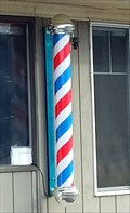 view gallery view galleryNE22.7 km |  The Whistle-Stop Barbershop HWY 58 Barber Pole - Oakridge, OR The Whistle-Stop Barbershop HWY 58 Barber Pole - Oakridge, OR
in Barber Poles This barbershop is located within a small strip mall along Hwy 58 in Oakridge. posted by: NW_history_buff location: Oregon date approved: 12/20/2014 last visited: never |
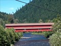 view gallery view galleryNE22.7 km |  LONGEST Covered Bridge in Oregon LONGEST Covered Bridge in Oregon
in Superlatives Office Creek Covered Bridge - Lane County, OR posted by: Prying Pandora location: Oregon date approved: 08/26/2007 last visited: 09/02/2012 |
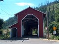 view gallery view galleryNE22.7 km |  Office Creek Covered Bridge Office Creek Covered Bridge
in Covered Bridges The longest covered bridge in Oregon. posted by: Prying Pandora location: Oregon date approved: 07/17/2007 last visited: 09/02/2012 |
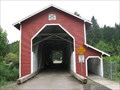
 view gallery view galleryNE22.7 km |  Office Bridge Office Bridge
in U.S. National Register of Historic Places The Office Bridge is the longest (180 feet long) covered bridge in Oregon and was listed on the historic register in 1979. posted by: TheBeanTeam location: Oregon date approved: 05/30/2008 last visited: 09/02/2012 |
 view gallery view galleryNE22.7 km |  Westfir, Oregon 97492 Westfir, Oregon 97492
in U.S. Post Offices This Post Office is located at 47395 Westoak Road in Westfir, Oregon. posted by: brwhiz location: Oregon date approved: 12/21/2011 last visited: never |
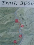 view gallery view galleryNE22.7 km |  Willamette Natl Forest, North Fork Trail-Gorge Section, OR Willamette Natl Forest, North Fork Trail-Gorge Section, OR
in 'You Are Here' Maps This sign provides information about the Gorge Section of the North Fork Trail of the Willamette National Forest (near Westfir, OR). posted by: Queens Blessing location: Oregon date approved: 08/24/2009 last visited: 09/02/2013 |
 view gallery view galleryNE22.7 km |  North Fork of the Middle Fork of the Willamette River OR North Fork of the Middle Fork of the Willamette River OR
in National Wild and Scenic Rivers The North Fork of the Middle Fork of the Willamette River
Oregon has been designated a "Wild and Scenic River". posted by: Queens Blessing location: Oregon date approved: 08/23/2009 last visited: 09/02/2012 |
 view gallery view galleryNE22.9 km |  West Cascades Scenic Byway - South Portal- Office Bridge West Cascades Scenic Byway - South Portal- Office Bridge
in National Scenic Byways The Southern access point of the 220 mile West Cascades Scenic Byway. posted by: TheBeanTeam location: Oregon date approved: 05/27/2008 last visited: 09/02/2012 |
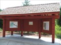
 view gallery view galleryNE22.9 km |  Westfir, Oregon - Birth of a Community Westfir, Oregon - Birth of a Community
in Signs of History This history sign (placed by the National Forest Service) provides the history of Westfir, Oregon (a company town). posted by: Queens Blessing location: Oregon date approved: 08/22/2009 last visited: 09/02/2013 |
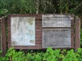
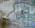 view gallery view galleryNE22.9 km | Westfir, Oregon in 'You Are Here' Maps This map is at the park in Westfir, Oregon, near the historic covered bridge. posted by: Queens Blessing location: Oregon date approved: 09/20/2009 last visited: 09/02/2013 |
 view gallery view galleryNE22.9 km | 2 You Are Here Maps at Westfir Covered Bridge, OR in 'You Are Here' Maps There are 2 more "You Are Here" maps on this sign. This town has a lot of you are here maps! posted by: Queens Blessing location: Oregon date approved: 08/24/2009 last visited: 09/02/2012 |
 view gallery view galleryNE22.9 km | Robert Aufderheide Memorial Drive, Westfir OR in National Scenic Byways The Robert Aufderheide Memorial Drive posted by: Queens Blessing location: Oregon date approved: 08/22/2009 last visited: 06/30/2013 |
|