 view gallery view gallery S4.7 km S4.7 km
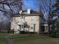
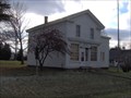
|   William H. Carson House William H. Carson House
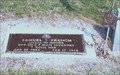
in Michigan Historical Markers Located on the north side of Burnside Street, west of Fremont Street. Streetside parking available. posted by:  S5280ft S5280ft location: Michigan date approved: 12/05/2006 last visited: 01/12/2015 |
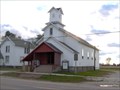
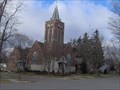 view gallery view galleryS4.7 km | First Presbyterian Church of Caro in Michigan Historical Markers Located on the northwest corner of West Lincoln and North Almer Streets. Plentiful parking at the church. posted by: S5280ft location: Michigan date approved: 10/17/2006 last visited: 01/12/2015 |
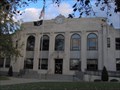 view gallery view galleryS4.7 km | Tuscola County Courthouse in Michigan Historical Markers Located on the east corner of East Sherman and North State Streets. Plentiful street parking available. posted by: S5280ft location: Michigan date approved: 10/17/2006 last visited: 01/18/2021 |
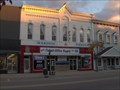
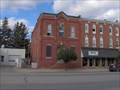
 view gallery view galleryS4.8 km | Tuscola County Advertiser in Michigan Historical Markers Located on the southeast side of North State Street between Sherman and Burnside Streets. Street parking available. posted by: S5280ft location: Michigan date approved: 10/17/2006 last visited: 09/27/2019 |
 view gallery view galleryS5 km | Caro Masonic Temple in Michigan Historical Markers Located on the southeast side of North State Street (M-81)between Frank and Lincoln Streets. Streetside parking available. LOOK ABOVE THE DOOR. posted by: S5280ft location: Michigan date approved: 10/17/2006 last visited: 01/18/2021 |
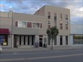
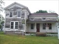
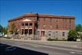 view gallery view galleryS5 km |  Hotel Montague Hotel Montague
in U.S. National Register of Historic Places An historic hotel converted into apartments. posted by: S5280ft location: Michigan date approved: 05/28/2008 last visited: never |
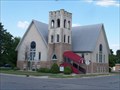
![Image for Trinity Episcopal Church [of Caro]](https://img.geocaching.com/waymarking/small/2c054dce-fdd0-46ff-9c15-2ef123967d2f.jpg) view gallery view galleryS5.1 km | Trinity Episcopal Church [of Caro] in Michigan Historical Markers Located on the southeast corner of Joy and South Almer Streets. Plentiful parking available. posted by: S5280ft location: Michigan date approved: 10/17/2006 last visited: 01/12/2015 |
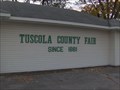 view gallery view galleryS5.6 km | Tuscola County Fair in Michigan Historical Markers Located within the entrance to the fairgrounds, on the southeast corner of East Congress and South Almer Streets. Abundant parking available. posted by: S5280ft location: Michigan date approved: 10/17/2006 last visited: 09/27/2019 |
 view gallery view galleryS5.6 km | Peninsular Sugar Refining Company in Michigan Historical Markers Located on the east side of South Almer Street, between East Congress and Peninsular Streets (DUH). Parking available at the Michigan Sugar Company Agricultural building. posted by: S5280ft location: Michigan date approved: 10/17/2006 last visited: 01/18/2021 |
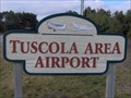 view gallery view gallery SW9.5 km SW9.5 km
|  Tuscola County Airport - Caro, MI Tuscola County Airport - Caro, MI
in Airports Located 3.9 miles southwest of M-24/M-81 Caro on Caro Road (M-81). Near Wahjamega. posted by: S5280ft location: Michigan date approved: 12/02/2006 last visited: 09/27/2019 |
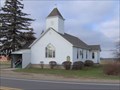 view gallery view gallerySW13.7 km | Watrousville United Methodist Church in Michigan Historical Markers Located on the north side of Caro Road (M-81), 0.1 miles east of Ringle Road. Parking available in the parking lot. posted by: S5280ft location: Michigan date approved: 12/05/2006 last visited: 01/12/2015 |
 view gallery view gallerySW14 km | Juniata House in Michigan Historical Markers Across the street from the other marker and is like the 3rd marker in a short stretch. Marked on side of road here. posted by:  Historic Markers Historic Markers location: Michigan date approved: 06/06/2016 last visited: 06/07/2016 |
 view gallery view gallerySW14 km | Watrous General Store in Michigan Historical Markers Located on the southwest corner of Caro Road (M-81) and 2nd Street. Parking available on 2nd Street. posted by: S5280ft location: Michigan date approved: 12/05/2006 last visited: 01/12/2015 |
 view gallery view gallery W18.8 km W18.8 km
|  Samuel S. French-Gilford, MI Samuel S. French-Gilford, MI
in Medal Of Honor Resting Places Civil War Medal of Honor Recipient for action at Fair Oaks, VA on May 31, 1862. He is buried in Gilford Cemetery, Gilford, MI. posted by: Don.Morfe location: Michigan date approved: 08/25/2018 last visited: 12/09/2021 |
 view gallery view galleryW19 km | Gilford United Methodist Church in Michigan Historical Markers Located on the west side of Bradleyville Road, just north of West Gilford Road. Parking available at the church. posted by: S5280ft location: Michigan date approved: 10/17/2006 last visited: 01/12/2015 |
 view gallery view gallery NE19 km NE19 km
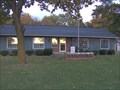
| Elkland Township Hall in Michigan Historical Markers Located on the north side of Main Street between West and Leach Streets. Streetside parking available. posted by: S5280ft location: Michigan date approved: 10/17/2006 last visited: 01/07/2014 |
 view gallery view galleryNE19.2 km | First Presbyterian Church (Cass City) in Michigan Historical Markers First Presbyterian Church in Cass City, sits in a quiet town. There is a parking lot diagonal from the church with prime parking and picture opportunities. posted by: Historic Markers location: Michigan date approved: 01/08/2014 last visited: 01/08/2014 |
 view gallery view galleryNE19.3 km |  Hello Mr. Chips - Cass City, Michigan Hello Mr. Chips - Cass City, Michigan
in Neon Signs A corner gas station in Cass City with an interesting name. And some great indoor neon. posted by: S5280ft location: Michigan date approved: 11/28/2007 last visited: never |
 view gallery view gallery NW19.6 km NW19.6 km
| Indian Dave in Michigan Historical Markers Located at the entrance to Wisner Cemetery, on the north side of Bay City-Forrestville Road, between Bradleyville and Garner Roads. Plentiful parking at the cemetery, or the nearby township office. posted by: S5280ft location: Michigan date approved: 10/17/2006 last visited: 09/02/2016 |
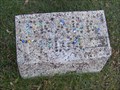 view gallery view galleryNW20 km |  Frank Thum - Wisner Cemetery Frank Thum - Wisner Cemetery
in Homemade Tombstones Marbles (not marble) spelling out a name set in concrete. posted by: S5280ft location: Michigan date approved: 10/28/2007 last visited: 06/04/2016 |
 view gallery view gallery E20.6 km E20.6 km
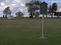
| State Reward Road No. 1 in Michigan Historical Markers A nice little roadside park just east of Cass City. posted by: Historic Markers location: Michigan date approved: 01/08/2014 last visited: 01/08/2014 |
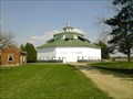 view gallery view galleryNE20.9 km |  Thumb Octagon Barn Thumb Octagon Barn
in Octagon Buildings An old Octagon barn used as a museum of times past. posted by: Team Us location: Michigan date approved: 09/24/2005 last visited: 03/11/2010 |
 view gallery view gallery N21.7 km N21.7 km
| The Indian Mission in Michigan Historical Markers Located on the south side of East Bay Street about 0.2 miles east of M-25 (Unionville Road/Beck Street). Parking available at the school. posted by: S5280ft location: Michigan date approved: 10/17/2006 last visited: 06/05/2016 |
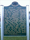 view gallery view galleryN22.2 km | John C. Liken / John C. Martini House in Michigan Historical Markers Located at 644 E. Main Street in the town of Sebewaing, MI. posted by: Team--B location: Michigan date approved: 11/03/2012 last visited: 09/02/2016 |
 view gallery view galleryN22.5 km | Sebewaing Township Hall in Michigan Historical Markers On Center / Grove St. Parking lot for the Hall, really easy to find. posted by: Historic Markers location: Michigan date approved: 06/06/2016 last visited: 10/06/2016 |
|