 view gallery view gallery NW16.3 km NW16.3 km
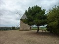
|   Le moulin de pesquies Le moulin de pesquies
in Windmills Le moulin à vent de Pesquies.
Restauré en 1991, il ne fonctionne plus. posted by:  niko_kristyn niko_kristyn location: Occitanie, France date approved: 07/31/2017 last visited: never |
 view gallery view gallery NE27.5 km NE27.5 km
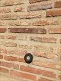
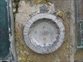
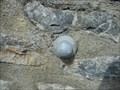
|  Repère de nivellement - Eglise Saint-Sernin - Villenouvelle, France Repère de nivellement - Eglise Saint-Sernin - Villenouvelle, France
in French Benchmarks Repère de nivellement sur l'église . Mur de facade posted by:  lynx36 lynx36 location: Occitanie, France date approved: 04/27/2020 last visited: 02/19/2019 |
 view gallery view gallery N27.7 km N27.7 km
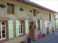
|  Au Gré du Temps - Donneville, France Au Gré du Temps - Donneville, France
in Bed and Breakfast [FR] Blottie au coeur du village de Donneville, à 15 mn au sud-est de Toulouse, à 10 mn du métro-parking et à deux pas du canal du midi. [EN] Located in the heart of the village of Donneville, 15 minutes south-west of Toulouse. posted by: RakeInTheCache location: Occitanie, France date approved: 05/07/2012 last visited: never |
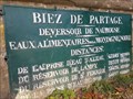 view gallery view galleryNE30.9 km |  Seuil de Naurouze, Montferrand, France Seuil de Naurouze, Montferrand, France
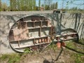
in Watershed Markers and Monuments [FR] Le seuil de Naurouze, à Montferrand marque le partage des eaux des bassins méditerranéen et atlantique
[EN] The threshold of Naurouze, in Montferrand marks the watershed of the Mediterranean and Atlantic basins posted by: junkys location: Occitanie, France date approved: 12/29/2017 last visited: never |
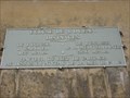
 view gallery view galleryNE30.9 km | NGF, Naurouze, Z'.E.Q3 - 17 (Canal du Midi - Partage des eaux) in French Benchmarks [FR] Paul Riquet fut le premier à découvrir ce site sur le seuil de partage des eaux. [EN] The Seuil de Naurouze is the watershed point identified by Pierre-Paul Riquet when he designed and built the Canal du Midi. posted by: RakeInTheCache location: Occitanie, France date approved: 05/05/2012 last visited: 03/22/2018 |
 view gallery view gallery S31.1 km S31.1 km
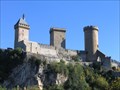
|  Chateau de Foix, France Chateau de Foix, France
in Castles Chateau de Foix, the castle of the Counts de Foix was a key center of resistance by the Counts de Foix and the Cathars against the Albigensian Crusade. The three towers are distinctive landmarks. posted by: arby101ca location: France date approved: 05/03/2010 last visited: 01/08/2020 |
 view gallery view galleryNW31.1 km |  L'hôtel à insectes de Lherm L'hôtel à insectes de Lherm
in Insect Hotels Magnifique hôtel à insectes posted by: niko_kristyn location: Occitanie, France date approved: 07/28/2017 last visited: never |
 view gallery view galleryS31.1 km | Benchmarck de l'agence de Foix in French Benchmarks Repère de nivellement de l'Ariège posted by: yohaeva location: Occitanie, France date approved: 08/28/2014 last visited: 01/08/2020 |
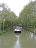 view gallery view galleryNE31.1 km |  Canal du Midi (Ecluse de l'Océan), France Canal du Midi (Ecluse de l'Océan), France
in World Heritage Sites [FR] Le canal du Midi est un canal français qui relie la Garonne à la mer Méditerranée. [EN] The Canal du Midi is a 240 km (150 mi) long canal in Southern France. posted by: RakeInTheCache location: Occitanie, France date approved: 05/16/2012 last visited: never |
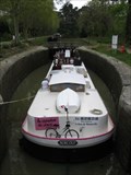 view gallery view galleryNE31.1 km |  L'écluse de l'Océan (Le Canal du Midi) - France L'écluse de l'Océan (Le Canal du Midi) - France
in Waterway Locks, Planes and Lifts [FR] L'écluse de l'Océan est une écluse à chambre unique sur le canal du Midi. [EN] Océan Lock is a single chamber lock on the Canal du Midi. posted by: RakeInTheCache location: Occitanie, France date approved: 05/19/2012 last visited: never |
 view gallery view galleryNE31.2 km |  Ecluse de l'Océan (Canal du Midi) - France Ecluse de l'Océan (Canal du Midi) - France
in Elevation Signs [FR] Le seuil de Naurouze est un seuil géographique (ou col) de 189 mètres d’altitude. [EN] The Seuil de Naurouze, aka Col de Naurouze, is a mountain pass in southern France. posted by: RakeInTheCache location: Occitanie, France date approved: 05/16/2012 last visited: never |
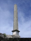 view gallery view galleryNE31.5 km |  L'obélisque de Riquet (Midi-Pyrénées) - France L'obélisque de Riquet (Midi-Pyrénées) - France
in Obelisks [FR] En 1825, les héritiers de Riquet font ériger un obélisque au seuil de Naurouze pour marquer la symbolique du lieu. [EN] The Riquet Obelisk is dedicated to the creater of the Canal du Midi, Pierre-Paul Riquet. posted by: RakeInTheCache location: Occitanie, France date approved: 05/16/2012 last visited: 03/22/2018 |
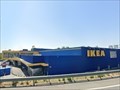 view gallery view galleryN33.2 km |  IKEA Toulouse - France IKEA Toulouse - France
in IKEA IKEA store in Toulouse posted by: Max93600 location: Occitanie, France date approved: 10/07/2021 last visited: never |
 view gallery view gallery SE35.9 km SE35.9 km
|  Fêtes historiques : Les Médiévales de Mirepoix - Ariège, Occitanie, France Fêtes historiques : Les Médiévales de Mirepoix - Ariège, Occitanie, France
in Renaissance Fairs [FR] Les Médiévales de Mirepoix se déroulent chaque année le 3ème week-end de juillet.
[EN] The Medieval of Mirepoix take place every year on the 3rd weekend of July. posted by: Waldog location: Occitanie, France date approved: 11/15/2018 last visited: 02/29/2020 |
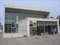 view gallery view galleryN36.5 km |  Ramonville - Toulouse, France Ramonville - Toulouse, France
in The Underground [FR] La station Ramonville est le terminus de la ligne B du métro de Toulouse. [EN] The Ramonville station is the terminus of line B of the Toulouse metro. posted by: RakeInTheCache location: Occitanie, France date approved: 05/07/2012 last visited: never |
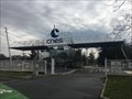 view gallery view galleryN37.2 km |  Le CNES - Toulouse - France Le CNES - Toulouse - France
in Research Institutes Le site du Centre national d'études spatiales.
The site of the National Center for Space Studies. posted by: Alfouine location: Centre-Val-de-Loire, France date approved: 04/17/2018 last visited: 05/24/2022 |
 view gallery view galleryN37.2 km |  Le CNES - Toulouse - France Le CNES - Toulouse - France
in Wikipedia Entries Le site du Centre national d'études spatiales.
The site of the National Center for Space Studies. posted by: Alfouine location: Occitanie, France date approved: 02/10/2018 last visited: never |
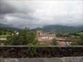
 view gallery view gallery SW37.2 km SW37.2 km
| Cathédrale Saint-Lizier - Saint-Lizier in World Heritage Sites Première cathédrale du village de Saint-Lizier avec son cloître roman, rare en Occitanie et le seul en Ariège. posted by: 09Naturel location: Occitanie, France date approved: 06/28/2018 last visited: 02/24/2020 |
 view gallery view gallerySW37.2 km |  Cathédrale Saint-Lizier - Saint-Lizier Cathédrale Saint-Lizier - Saint-Lizier
in Monuments Historiques Français Première cathédrale du village de Saint-Lizier avec son cloître roman, rare en Occitanie et le seul en Ariège. posted by: 09Naturel location: Occitanie, France date approved: 06/28/2018 last visited: 02/24/2020 |
 view gallery view gallerySW37.2 km |  Cathédrale Saint-Lizier - Saint-Lizier Cathédrale Saint-Lizier - Saint-Lizier
in Cathedrals Première cathédrale du village de Saint-Lizier avec son cloître roman, rare en Occitanie et le seul en Ariège. posted by: 09Naturel location: Occitanie, France date approved: 06/28/2018 last visited: 02/24/2020 |
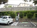 view gallery view gallerySW37.3 km |  Borne de recharge - Vigne de l'évêché, Saint-Lizier Borne de recharge - Vigne de l'évêché, Saint-Lizier
in Electric Car Charging Stations 2 points de charge disponibles, place Vigne de L'Eveche, d'une puissance de 22kW max chacun. posted by: 09Naturel location: Occitanie, France date approved: 06/27/2018 last visited: 02/24/2020 |
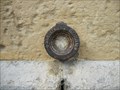
 view gallery view gallerySW37.5 km | Benchmark - EE' - 43 BIS - Saint-Lizier in French Benchmarks Localisation : AU NORD-OUEST DU CARREFOUR GIRATOIRE AVEC LA D.33A
Support : MUR DE CLOTURE
*** Ce repère n'a pas été observé par l' I.G.N.
Altitude : 386,417 m posted by: eolas location: Occitanie, France date approved: 02/21/2013 last visited: never |
 view gallery view gallerySW37.8 km | Benchmark - ANCIEN COLLEGE D'ENSEIGNEMENT TECHNIQUE in French Benchmarks Localisation : A SAINT-GIRONS, AU NO 28 DE L'AVENUE RENE PLAISANT
Support : MAISON (ANCIEN COLLEGE D'ENSEIGNEMENT TECHNIQUE)
Altitude : 390,435 m posted by: eolas location: Occitanie, France date approved: 02/21/2013 last visited: never |
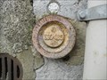
 view gallery view gallerySW37.8 km | Benchmark - EGLISE DE LORP in French Benchmarks Partie support : ABOUT DU TROISIEME CONTREFORT A COMPTER DE LA ROUTE, DANS LE MUR DE FACADE
ANTERIEUR
Altitude : 377,995 m posted by: eolas location: Occitanie, France date approved: 02/21/2013 last visited: never |
 view gallery view gallerySW37.8 km | Benchmark - LA PEYRADE - Lorp in French Benchmarks Localisation : AU LIEU-DIT "LA PEYRADE", AU NO 26, AVENUE CHARLES DE GAULLE
Altitude : 377,331 m posted by: eolas location: Occitanie, France date approved: 02/21/2013 last visited: 09/17/2009 |
|