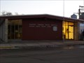
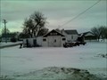
 view gallery view gallery NW9.8 km NW9.8 km
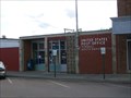
|   Wagner, South Dakota 57380 Wagner, South Dakota 57380
in U.S. Post Offices Small town post office.
elevation 1454 posted by:  NGComets NGComets location: South Dakota date approved: 03/24/2013 last visited: never |
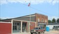
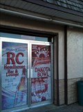 view gallery view galleryNW10 km |  Dakota Bowl, Wagner, South Dakota Dakota Bowl, Wagner, South Dakota
in Bowling Centres 107 North Main, Wagner, SD.
Elevation 1424 posted by: NGComets location: South Dakota date approved: 04/08/2013 last visited: never |
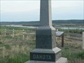
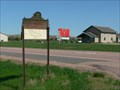
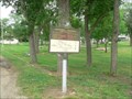 view gallery view gallery E10.8 km E10.8 km
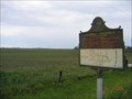
|  Historic Highway >-----> 11.5 Miles S of Avon Historic Highway >-----> 11.5 Miles S of Avon
in South Dakota Historical Markers Missouri River Historic Highway 11.5 miles S of Avon with Running Water, Springfield, old Ft. Mitchell, and Niobrara, NE nearby. posted by: plainsdrifter358 location: South Dakota date approved: 07/07/2006 last visited: 06/11/2006 |
 view gallery view galleryE10.8 km | Avon, SD Birthplace of Senator George McGovern in South Dakota Historical Markers Avon, SD: Birthplace of Senator and US Presidential Candidate George McGovern. posted by: plainsdrifter358 location: South Dakota date approved: 07/07/2006 last visited: 06/11/2006 |
 view gallery view gallery W20.3 km W20.3 km
| Martin Marty & Rev Sylvester Eisenman in South Dakota Historical Markers "Martin Marty & Rev Sylvester Eisenman" HM in Marty, SD posted by: plainsdrifter358 location: South Dakota date approved: 04/30/2006 last visited: 04/30/2006 |
 view gallery view gallery SW20.4 km SW20.4 km
| Yankton Dakota Sioux Treaty of 1858 in South Dakota Historical Markers Yankton Dakota Sioux Tribe Treaty of 1858 posted by: plainsdrifter358 location: South Dakota date approved: 05/20/2006 last visited: 05/21/2006 |
 view gallery view galleryNW22.5 km | Ravinia Consolidated School in South Dakota Historical Markers Ravinia Consolidated School established in 1910 posted by: plainsdrifter358 location: South Dakota date approved: 05/21/2006 last visited: 08/10/2016 |
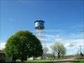
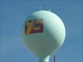 view gallery view galleryW24 km |  Fort Randall Casino Water Tower Fort Randall Casino Water Tower
in Water Towers This water tower is at the Fort Randall Casino & Hotel. posted by: PeterNoG location: South Dakota date approved: 06/06/2011 last visited: 08/30/2012 |
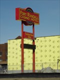 view gallery view galleryW24 km |  Fort Randall Casino & Hotel Fort Randall Casino & Hotel
in Casinos This casino, owned and operated by the Yankton Sioux Tribe, is on Hwy 46 between Pickstown and Wagner in South Dakota. posted by: PeterNoG location: South Dakota date approved: 06/08/2011 last visited: 03/14/2011 |
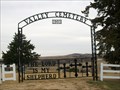 view gallery view gallery S25.1 km S25.1 km
|  Valley Cemetery, Verdel, Nebraska Valley Cemetery, Verdel, Nebraska
in Worldwide Cemeteries Also known as Ponca Valley Cemetery.
Elevation 1327 posted by: NGComets location: Nebraska date approved: 12/13/2017 last visited: never |
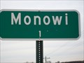 view gallery view gallerySW26.2 km |  Monowi, Nebraska - Population 1 Monowi, Nebraska - Population 1
in Population Signs A very small town along Highway 12 in northern Nebraska. Elevation 1354. posted by: NGComets location: Nebraska date approved: 12/17/2017 last visited: never |
 view gallery view galleryE26.4 km |  Bon Homme County Courthouse, Tyndall, SD Bon Homme County Courthouse, Tyndall, SD
in Courthouses This beautiful Beaux Arts Style courthouse was built in 1914. posted by:  NevaP NevaP location: South Dakota date approved: 05/12/2008 last visited: 02/15/2023 |
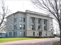 view gallery view galleryE26.4 km |  Bon Homme County Courthouse, Tyndall, SD Bon Homme County Courthouse, Tyndall, SD
in U.S. National Register of Historic Places Bon Homme County's second courthouse was constructed in 1914. posted by: NevaP location: South Dakota date approved: 05/12/2008 last visited: 02/15/2023 |
 view gallery view galleryE26.7 km | Watertower, Tyndall, South Dakota in Water Towers Small town watertower. Nicely decorated and constructed in the mid 30's to supply water for the town. posted by: NGComets location: South Dakota date approved: 06/14/2012 last visited: 02/15/2023 |
 view gallery view galleryE26.7 km | Tyndall, South Dakota 57066 in U.S. Post Offices Small town post office in the County Seat. posted by: NGComets location: South Dakota date approved: 06/15/2012 last visited: 02/15/2023 |
 view gallery view galleryE26.7 km |  Tyndall, SD USA Tyndall, SD USA
in Wikipedia Entries The small town of Tyndall, seat of Bon Homme county SD, has its own Wikipedia article. posted by: Benchmark Blasterz location: South Dakota date approved: 02/15/2023 last visited: 02/16/2023 |
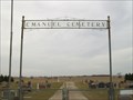 view gallery view gallery SE27.2 km SE27.2 km
| Emanuel Cemetery, Springfield, South Dakota in Worldwide Cemeteries In Bon Homme County, South Dakota, about 5 miles west of Springfield.
Elevation 1476. posted by: NGComets location: South Dakota date approved: 12/13/2017 last visited: never |
 view gallery view gallery NE27.8 km NE27.8 km
|  Heinne Prien Blacksmith - Tripp, SD Heinne Prien Blacksmith - Tripp, SD
in Blacksmith Shops A blacksmith and welding shop that is still in business, but open by appointment only. posted by: beta59 location: South Dakota date approved: 01/27/2012 last visited: never |
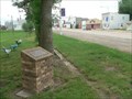
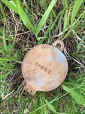
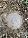 view gallery view galleryW28 km |  46 277.40 - Charles Mix County, SD 46 277.40 - Charles Mix County, SD
in U.S. Benchmarks Benchmark disk posted by: CampDoggs location: South Dakota date approved: 06/30/2022 last visited: never |
 view gallery view galleryW28.5 km | Historic Highway ~ 2 blocks S then E in South Dakota Historical Markers Map of 1856 highway from Yankton to Pickstown along the Missouri River. posted by: plainsdrifter358 location: South Dakota date approved: 05/21/2006 last visited: 04/28/2013 |
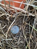 view gallery view galleryW28.6 km | 1005 (OR0263) - Pickstown, SD in U.S. Benchmarks Bolt set in concrete. posted by: CampDoggs location: South Dakota date approved: 06/30/2022 last visited: never |
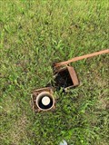
 view gallery view galleryW29.3 km | DON (OR1140) - Pickstown, SD in U.S. Benchmarks Pipe encased inside a galvanized pipe. posted by: CampDoggs location: South Dakota date approved: 06/30/2022 last visited: never |
 view gallery view galleryW29.3 km | 4 (OR1139) - Pickstown, SD in U.S. Benchmarks Pipe encased in PVC, iron cap. posted by: CampDoggs location: South Dakota date approved: 06/30/2022 last visited: never |
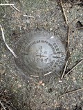 view gallery view galleryW29.8 km | J 336 (OR0257) - Pickstown, SD in U.S. Benchmarks Benchmark disk set in concrete. posted by: CampDoggs location: South Dakota date approved: 06/30/2022 last visited: never |
 view gallery view gallerySE29.8 km | Historic Highway -------->S through Springfield Bon Homme was 7 in South Dakota Historical Markers historic highway posted by: MNSearchers location: South Dakota date approved: 06/29/2006 last visited: 08/08/2007 |
|