 view gallery view gallery N0.8 km N0.8 km
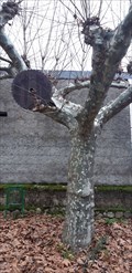
|   Árbol glotón en Éntoma - O Barco de Valdeorras, Ourense, España Árbol glotón en Éntoma - O Barco de Valdeorras, Ourense, España
in Omnivorous Trees Un platanero de sombra (platanus hispanica) muy glotón // A very gluttonous platanus hispanica posted by:  xeocach xeocach location: Galicia, Spain date approved: 01/13/2023 last visited: never |
 view gallery view gallery NE1.1 km NE1.1 km
|  Ponte de Éntoma - O Barco de Valdeorras, Ourense, España Ponte de Éntoma - O Barco de Valdeorras, Ourense, España
in Arch Bridges Puente sobre el río Galir // Bridge over the Galir river posted by: xeocach location: Galicia, Spain date approved: 01/14/2023 last visited: never |
 view gallery view galleryNE1.1 km |  Ponte de Éntoma - O Barco de Valdeorras, Ourense, España Ponte de Éntoma - O Barco de Valdeorras, Ourense, España
in Stone Bridges Puente sobre el río Galir // Bridge over the Galir river posted by: xeocach location: Galicia, Spain date approved: 01/19/2023 last visited: never |
 view gallery view gallery W3.2 km W3.2 km
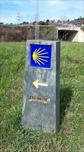
|  Banco Peregrino - O Barco de Valdeorras, Ourense, España Banco Peregrino - O Barco de Valdeorras, Ourense, España
in Way of St. James Un repouso antes de retomar o Camiño de Inverno // A rest before resuming the Winter’s Way of St. James posted by: xeocach location: Galicia, Spain date approved: 01/13/2024 last visited: never |
 view gallery view galleryW3.4 km |  325m - O Barco, Ourense, España 325m - O Barco, Ourense, España
in Elevation Signs Elevación sobre el nivel medio del Mediterráneo en Alicante // Elevation above the mean level of the Mediterranean Sea in Alicante posted by: xeocach location: Galicia, Spain date approved: 12/08/2022 last visited: never |
 view gallery view galleryW3.4 km |  O Barco de Valdeorras - Ourense, España O Barco de Valdeorras - Ourense, España
in Vértices Geodésicos Punto de referencia en la fachada de la Casa Consistorial con Coordenadas Geográficas Permanentes grabadas // Benchmark on the facade of the Town Hall with Permanent Geographic Coordinates engraved posted by: xeocach location: Galicia, Spain date approved: 12/10/2022 last visited: never |
 view gallery view galleryW3.4 km |  N 42º 24’ 59,2’’ W 6º 59’ 04,7’’ - O Barco, Ourense, España N 42º 24’ 59,2’’ W 6º 59’ 04,7’’ - O Barco, Ourense, España
in Permanent Geographic Coordinates Punto de referencia en la fachada de la Casa Consistorial con Coordenadas Geográficas Permanentes grabadas // Benchmark on the facade of the Town Hall with Permanent Geographic Coordinates engraved posted by: xeocach location: Galicia, Spain date approved: 12/15/2022 last visited: never |
 view gallery view galleryW3.5 km | Km 212,354 do Camiño de Inverno - O Barco de Valdeorras, Ourense, España in Way of St. James A Catedral compostelá está a 212,354 km // Compostela Cathedral is 212,354 km away posted by: xeocach location: Galicia, Spain date approved: 07/26/2023 last visited: never |
 view gallery view galleryW4.3 km |  O Barco se anuncia colocando grandes letras de pizarra - O Barco de Valdeorras, Ourense, España O Barco se anuncia colocando grandes letras de pizarra - O Barco de Valdeorras, Ourense, España
in News Article Locations Noticia sobre la colocación del nombre de la villa en letras gigantes en la rotonda de Veigamuiños // News about the placement of the name of the town in giant letters in the Veigamuiños roundabout posted by: xeocach location: Galicia, Spain date approved: 03/04/2023 last visited: never |
 view gallery view galleryW4.3 km |  O Barco - O Barco de Valdeorras, Ourense, España O Barco - O Barco de Valdeorras, Ourense, España
in City Names in Giant Letters En una de las entradas a O Barco desde la N-120 una rotonda nos da la bienvenida con el nombre de la villa en letras gigantes // At one of the entrances to O Barco from the N-120, a roundabout welcomes us with the name of the town in giant letters posted by: xeocach location: Comunidad de Madrid, Spain date approved: 03/04/2023 last visited: never |
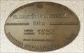
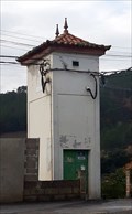
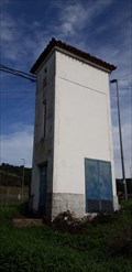 view gallery view galleryW5.8 km |  32CB73 - A Proba, O Barco de Valdeorras, Ourense, España 32CB73 - A Proba, O Barco de Valdeorras, Ourense, España
in Historic Transformer Sub-Stations Buildings Subestación transformadora ubicada en A Proba // Transformer substation tower located in A Proba posted by: xeocach location: Galicia, Spain date approved: 08/04/2023 last visited: never |
 view gallery view galleryW6 km | Km 208,779 do Camiño de Inverno - A Proba, O Barco de Valdeorras, Ourense, España in Way of St. James A Catedral compostelá está a 208,779 km // Compostela Cathedral is 208,779 km away posted by: xeocach location: Galicia, Spain date approved: 07/26/2023 last visited: never |
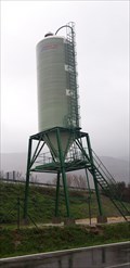 view gallery view galleryW6.1 km |  Silo en A Proba - O Barco de Valdeorras, Ourense, España Silo en A Proba - O Barco de Valdeorras, Ourense, España
in Solitary Silos Silo de vialidad invernal // Winter road silo posted by: xeocach location: Galicia, Spain date approved: 01/28/2023 last visited: never |
 view gallery view galleryW6.9 km | Km 207,626 do Camiño de Inverno - Arcos, Vilamartín de Valdeorras, Ourense, España in Way of St. James A Catedral compostelá está a 207,626 km // Compostela Cathedral is 207,626 km away posted by: xeocach location: Galicia, Spain date approved: 05/30/2023 last visited: never |
 view gallery view galleryW9.2 km |  Pasarela de Penouta - Vilamartín de Valdeorras, Ourense, España Pasarela de Penouta - Vilamartín de Valdeorras, Ourense, España
in Pedestrian Suspension Bridges Pasarela peatonal sobre el río Sil // Pedestrian footbridge over the river Sil posted by: xeocach location: Galicia, Spain date approved: 03/25/2023 last visited: never |
 view gallery view galleryW10 km | Vilamartín de Valdeorras - Ourense, España in Vértices Geodésicos Marca de nivel en la fachada de la Casa Consistorial con Coordenadas Geográficas Permanentes grabadas // Level mark on the facade of the Town Hall with Permanent Geographic Coordinates posted by: xeocach location: Galicia, Spain date approved: 01/04/2023 last visited: never |
 view gallery view galleryW10 km | 318m - Vilamartín de Valdeorras, Ourense, España in Elevation Signs Elevación sobre el nivel medio del Mediterráneo en Alicante // Elevation above the mean level of the Mediterranean Sea in Alicante posted by: xeocach location: Galicia, Spain date approved: 12/30/2022 last visited: never |
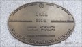
 view gallery view galleryW10 km | N 42° 24' 55,8'' W 7° 03' 51,5'' - Vilamartín de Valdeorras, Ourense, España in Permanent Geographic Coordinates Punto de referencia en la fachada de la Casa Consistorial con Coordenadas Geográficas Permanentes grabadas // Benchmark on the facade of the Town Hall with Permanent Geographic Coordinates engraved posted by: xeocach location: Galicia, Spain date approved: 12/30/2022 last visited: never |
 view gallery view galleryW10 km | 32CB83 - Vilamartín de Valdeorras, Ourense, España in Historic Transformer Sub-Stations Buildings Subestación transformadora ubicada en calle Carmen Padilla de Vilamartín de Valdeorras // Transformer substation tower located in Vilamartín de Valdeorras posted by: xeocach location: Galicia, Spain date approved: 01/29/2023 last visited: never |
 view gallery view galleryW13 km | N-120 Km465,5 – A Rúa, Ourense, España in Solitary Silos Silo de vialidad invernal // Winter road silo posted by: xeocach location: Galicia, Spain date approved: 05/29/2023 last visited: never |
 view gallery view galleryW14.2 km | A Rúa - Ourense, España in Vértices Geodésicos Punto de referencia en la fachada de la Casa Consistorial con Coordenadas Geográficas Permanentes grabadas // Benchmark on the facade of the Town Hall with Permanent Geographic Coordinates engraved posted by: xeocach location: Galicia, Spain date approved: 02/03/2023 last visited: never |
 view gallery view galleryW14.2 km | 308m - A Rúa, Ourense, España in Elevation Signs Elevación sobre el nivel medio del Mediterráneo en Alicante // Elevation above the mean level of the Mediterranean Sea in Alicante posted by: xeocach location: Galicia, Spain date approved: 02/01/2023 last visited: never |
 view gallery view galleryW14.2 km | N42º 23’ 42,5’’ W7º 6’ 50,9’’ - A Rúa, Ourense, España in Permanent Geographic Coordinates Marca de nivel en la fachada de la Casa Consistorial con Coordenadas Geográficas Permanentes grabadas // Level mark on the facade of the Town Hall with Permanent Geographic Coordinates posted by: xeocach location: Galicia, Spain date approved: 02/01/2023 last visited: never |
 view gallery view galleryW14.5 km |  O Aguillón - A Rúa, Ourense, España O Aguillón - A Rúa, Ourense, España
in Fitness Trails Área de entrenamiento físico en un lateral del antiguo campo de fútbol de O Aguillón // Physical training area on one side of the old O Aguillón soccer field posted by: xeocach location: Galicia, Spain date approved: 02/01/2023 last visited: never |
 view gallery view galleryW14.5 km |  O Aguillón - A Rúa, Ourense, España O Aguillón - A Rúa, Ourense, España
in Public Playgrounds Parque infantil en el área recreativa de O Aguillón // Children's playground in the recreational area of O Aguillón posted by: xeocach location: Galicia, Spain date approved: 02/01/2023 last visited: never |
|