 view gallery view gallery N20.8 km N20.8 km
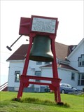
|   Eastern Point Lighthouse Fog Bell - East Gloucester, MA Eastern Point Lighthouse Fog Bell - East Gloucester, MA
in Bells The Eastern Point Lighthouse bell is a prominent feature on the fenced in grounds of the Eastern Point Lighthouse in East Gloucester. posted by:  neoc1 neoc1 location: Massachusetts date approved: 10/23/2011 last visited: 10/20/2023 |
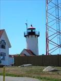
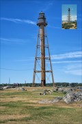
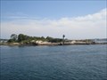
 view gallery view galleryN20.8 km |  Eastern Point Lighthouse - East Gloucester, MA Eastern Point Lighthouse - East Gloucester, MA
in Coastal Lighthouses Eastern Point Lighthouse is located at the entrance to Gloucester Harbor. posted by: neoc1 location: Massachusetts date approved: 10/23/2011 last visited: 10/20/2023 |
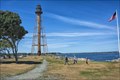
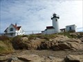 view gallery view galleryN20.8 km |  Eastern Point Light - East Gloucester, MA Eastern Point Light - East Gloucester, MA
in Wikipedia Entries Eastern Point Lighthouse is located at the north entrance to Gloucester Harbor at the tip of Cape Ann in East Gloucester, MA. posted by: neoc1 location: Massachusetts date approved: 09/19/2017 last visited: 10/20/2023 |
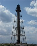
 view gallery view galleryN20.8 km |  Eastern Point Lighthouse - East Gloucester, MA Eastern Point Lighthouse - East Gloucester, MA
in Philatelic Photographs Eastern Point Lighthouse is located at the entrance to Gloucester Harbor. posted by: neoc1 location: Massachusetts date approved: 10/29/2011 last visited: 10/20/2023 |
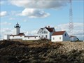 view gallery view galleryN20.8 km |  Eastern Point Lighthouse - East Gloucester, MA Eastern Point Lighthouse - East Gloucester, MA
in Satellite Imagery Oddities Eastern Point Lighthouse is located at the entrance to Gloucester Harbor in East Glocester, MA. posted by: neoc1 location: Massachusetts date approved: 08/12/2018 last visited: 10/20/2023 |
 view gallery view galleryN20.8 km |  Eastern Point Light Station - Gloucester MA Eastern Point Light Station - Gloucester MA
in U.S. National Register of Historic Places Eastern Point Lighthouse is located in Gloucester MA and was listed on the register in 1987 posted by:  nomadwillie nomadwillie location: Massachusetts date approved: 12/21/2008 last visited: 10/20/2023 |
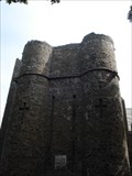 view gallery view galleryN21.9 km |  Hammond Castle - Gloucester, MA Hammond Castle - Gloucester, MA
in Castles Hammond castle is located along the coast just west of Gloucester, MA. posted by:  Lightnin Bug Lightnin Bug location: Massachusetts date approved: 09/24/2010 last visited: 06/21/2015 |
 view gallery view gallery NW22.4 km NW22.4 km
|  Chandler Hovey Park - Marblehead MA Chandler Hovey Park - Marblehead MA
in Municipal Parks and Plazas Home to Marblehead Light, which is on the National Register of Historic Places posted by: nomadwillie location: Massachusetts date approved: 12/31/2015 last visited: never |
 view gallery view gallery W22.5 km W22.5 km
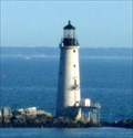
| Graves Light Station - The Graves, Boston Harbor Islands, Plymouth County, MA in Coastal Lighthouses Graves Light Station is located on The Graves, the outermost of the Boston Harbor Islands National Recreation Area in Boston, MA. posted by: neoc1 location: Massachusetts date approved: 01/25/2023 last visited: never |
 view gallery view galleryW22.5 km | Graves Light Station - Boston Harbor Islands, Plymouth County, MA in Wikipedia Entries Graves Light Station is located on The Graves, the outermost of the Boston Harbor Islands National Recreation Area in Plymouth County, MA. posted by: neoc1 location: Massachusetts date approved: 01/28/2023 last visited: never |
 view gallery view galleryW22.5 km | Graves Light Station - Boston Harbor Islands, Plymouth County, MA in U.S. National Register of Historic Places Graves Light Station is located on The Graves, the outermost of the Boston Harbor Islands National Recreation Area in Plymouth County, MA. posted by: neoc1 location: Massachusetts date approved: 01/28/2023 last visited: never |
 view gallery view galleryNW22.5 km |  Marblehead Light - Marblehead MA Marblehead Light - Marblehead MA
in Picture Perfect Postcards The Marblehead Light was constructed in 1895 posted by: nomadwillie location: Massachusetts date approved: 01/02/2016 last visited: 11/23/2013 |
 view gallery view galleryNW22.5 km | Marblehead Light - Marblehead MA in U.S. National Register of Historic Places The Marblehead Light was constructed in 1895 posted by: nomadwillie location: Massachusetts date approved: 12/30/2015 last visited: 11/23/2013 |
 view gallery view galleryNW22.5 km | Marblehead Light (Massachusetts) in Wikipedia Entries The Marblehead Light was constructed in 1895, listed on the National Register of Historic Places. posted by: nomadwillie location: Massachusetts date approved: 01/02/2016 last visited: 11/23/2013 |
 view gallery view galleryNW22.5 km | Marblehead Light - Marblehead MA in Coastal Lighthouses The Marblehead Light was constructed in 1895 posted by: nomadwillie location: Massachusetts date approved: 01/01/2016 last visited: 11/23/2013 |
 view gallery view galleryNW22.5 km |  Marblehead Light - Marblehead MA Marblehead Light - Marblehead MA
in American Guide Series The Marblehead Light was constructed in 1895 posted by: nomadwillie location: Massachusetts date approved: 01/06/2016 last visited: 11/23/2013 |
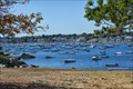
 view gallery view galleryNW22.5 km |  Coolidge Reservation Coolidge Reservation
in Public Access Lands A 66 acre property in Manchester-by-the-Sea, Massachusetts, that has it all: spectacular ocean views, wetland, forest, a tidally influenced coastal salt water pond, and even a hill with glacial scratches on the bedrock. posted by: bctrail location: Massachusetts date approved: 07/11/2009 last visited: never |
 view gallery view galleryNW22.5 km |  Marblehead Neck - USED STA NECK ELEV Marblehead Neck - USED STA NECK ELEV
in U.S. Benchmarks An U.S. Engineer Department disk set in the top of a rock outcrop in Chandler Hovey Park at Marblehead Neck. posted by: king.hubi location: Massachusetts date approved: 06/15/2009 last visited: never |
 view gallery view galleryNW22.5 km |  Marblehead Light Marblehead Light
in Massachusetts Historical Markers At the northernmost point of Marblehead Neck, now Chandler Hovey Park, is the location where a lighthouse has been since 1835. posted by: NorStar location: Massachusetts date approved: 09/20/2007 last visited: 11/23/2013 |
 view gallery view galleryN23 km | Ten Pound Island - Gloucester, MA in American Guide Series Ten Pound Island is in Gloucester Harbor. posted by: Lightnin Bug location: Massachusetts date approved: 11/26/2010 last visited: never |
 view gallery view galleryN23 km | Ten Pound Island Light - Gloucester, MA in Coastal Lighthouses Ten Pound Island Lighthouse is in Gloucester Harbor. posted by: Lightnin Bug location: Massachusetts date approved: 11/28/2010 last visited: 10/29/2022 |
 view gallery view galleryW23.2 km |  Vietnam War Memorial, Traffic Island Park, Lynn, MA, USA Vietnam War Memorial, Traffic Island Park, Lynn, MA, USA
in Vietnam War Memorials Lynn, Massachusetts, Vietnam War memorial, dedicated to the 35 men of Essex County who lost their lives in the war. The names of those who lost their lives in the war are engraved around the base of the memorial. posted by: HANSENNI location: Massachusetts date approved: 10/29/2009 last visited: never |
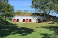 view gallery view galleryNW23.2 km | Fort Sewall in Wikipedia Entries Fort Sewall, formerly an armed fort owned by the United States and used to defend against British invaders, is now a peaceful park offering some of the best views of Marblehead Harbor. posted by: nomadwillie location: Massachusetts date approved: 01/05/2016 last visited: never |
 view gallery view galleryNW23.2 km | Fort Sewell - Marblehead MA in American Guide Series Fort Sewall, formerly an armed fort owned by the United States and used to defend against British invaders, is now a peaceful park offering some of the best views of Marblehead Harbor. posted by: nomadwillie location: Massachusetts date approved: 01/06/2016 last visited: never |
 view gallery view galleryNW23.2 km |  Fort Sewell - Marblehead MA Fort Sewell - Marblehead MA
in People-Named Places Fort Sewall, formerly an armed fort owned by the United States and used to defend against British invaders, is now a peaceful park offering some of the best views of Marblehead Harbor. posted by: nomadwillie location: Massachusetts date approved: 01/06/2016 last visited: never |
|