 view gallery view gallery SW0.3 km SW0.3 km
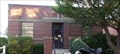
|   Where's the Fire?-Slow Down - Needham, MA Where's the Fire?-Slow Down - Needham, MA
in Unusual Signs This artistically designed sign is one of a series of signs featuring student artwork designed to catch the attention of the driver to slow down. posted by:  NorStar NorStar location: Massachusetts date approved: 02/16/2009 last visited: never |
 view gallery view gallerySW0.6 km |  Highland Animal Hospital - Needham, MA Highland Animal Hospital - Needham, MA
in Animal Hospitals Highland Animal Hospital provides veterinary services and kennel services for dogs, cats, birds, ferrets, rabbits, guinea pigs, hamsters, gerbils, mice, rats hedgehogs and reptiles. posted by: NorStar location: Massachusetts date approved: 04/30/2010 last visited: never |
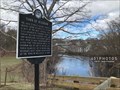 view gallery view gallery E0.8 km E0.8 km
|  Town of Needham - Needham, Massachusetts Town of Needham - Needham, Massachusetts
in Massachusetts Historical Markers This Massachusetts historical marker presents a brief overview about the formation of Needham, Massachusetts between 1635 and 1881. The plaque can be found immediately west of Cook's Bridge where Central Avenue becomes Elliot Street. posted by:  401Photos 401Photos location: Massachusetts date approved: 05/22/2019 last visited: never |
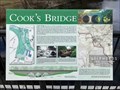
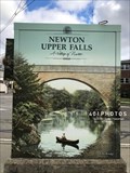
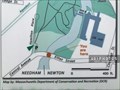 view gallery view galleryE0.8 km |  You Are Here - Cook's Bridge - Newton Upper Falls, Massachusetts USA You Are Here - Cook's Bridge - Newton Upper Falls, Massachusetts USA
in 'You Are Here' Maps A map of the Needham, Newton, and Wellesly area of Massachusetts is incorporated in the design of an historic marker on Cook's Bridge in the village of Newton Upper Falls. It includes a "You Are Here" spot labeled near the bottom edge of the map. posted by: 401Photos location: Massachusetts date approved: 04/14/2019 last visited: never |
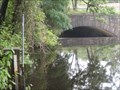
 view gallery view galleryE0.8 km | Cook's Bridge - Newton Upper Falls, Massachusetts in Massachusetts Historical Markers A Massachusetts historical marker can be visited on Cook's Bridge along Elliot Street in the village of Newton Upper Falls. posted by: 401Photos location: Massachusetts date approved: 05/22/2019 last visited: never |
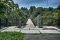
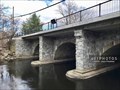 view gallery view galleryE0.8 km |  Cook's Bridge - Newton Upper Falls, Massachusetts USA Cook's Bridge - Newton Upper Falls, Massachusetts USA
in Stone Bridges The historic, stone Cook's Bridge carries Elliot Street over the Charles River in the village of Newton Upper Falls, Massachusetts. posted by: 401Photos location: Massachusetts date approved: 06/14/2019 last visited: never |
 view gallery view gallery NW0.8 km NW0.8 km
|  The Wok - Wellesley, MA The Wok - Wellesley, MA
in Chinese Restaurants The Wok is a nice sit down restaurant along Route 9. posted by: NorStar location: Massachusetts date approved: 06/08/2012 last visited: never |
 view gallery view gallery NE0.8 km NE0.8 km
|  Disk No. K37/MY2088 - Wellesley, MA Disk No. K37/MY2088 - Wellesley, MA
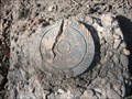
in U.S. Benchmarks This survey disk is in the ground, protected by a plastic shroud, and is located near ramps for the I-95/Route 9 intersection. posted by: NorStar location: Massachusetts date approved: 02/28/2010 last visited: never |
 view gallery view galleryE1 km | You Are Here - Echo Bridge Office Park - Newton Upper Falls, Massachusetts USA in 'You Are Here' Maps A large directory mounted on the south exterior wall of Echo Bridge Office Park in Newton Upper Falls, Massachusetts. It features a brown site plan, a red "You Are Here" triangle, and a listing of all the businesses at this site. posted by: 401Photos location: Massachusetts date approved: 04/14/2019 last visited: never |
 view gallery view gallery SE1 km SE1 km
|  WCVB Channel 5 - Boston, MA WCVB Channel 5 - Boston, MA
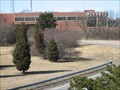
in Television and Cable Broadcasting Stations WCVB, Channel 5, is an ABC affiliated station located in the suburb of Needham that serves the Boston metropolitan area as well as other parts of New England on cable. posted by: NorStar location: Massachusetts date approved: 03/11/2009 last visited: never |
 view gallery view galleryNE1 km | Echo Bridge Aqueduct - Needham, MA in Stone Bridges Echo Bridge is a beautiful tall bridge that once carried Boston's water over Hemlock Gorge and the Charles River. posted by: NorStar location: Massachusetts date approved: 09/15/2008 last visited: never |
 view gallery view galleryNE1 km |  Echo Bridge Aqueduct - Needham, MA Echo Bridge Aqueduct - Needham, MA
in Arch Bridges Echo Bridge, a former aqueduct for the Boston metropolitan area, is a series of beautiful stone arches, one of which give the bridge its name. posted by: NorStar location: Massachusetts date approved: 10/21/2008 last visited: never |
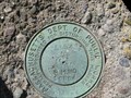
 view gallery view galleryNE1 km | USGS Reference Mark - Newton, MA in U.S. Benchmarks This survey reference mark was placed on the concrete base for the U.S.G.S river gaging station. posted by: NorStar location: Massachusetts date approved: 09/14/2008 last visited: never |
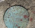
 view gallery view galleryNE1 km |  USGS 01104200 Charles River at Wellesley, MA USGS 01104200 Charles River at Wellesley, MA
in River Gauges This gauge is located on the Charles River, just above Horseshoe Dam, in beautiful Hemlock Gorge. posted by: NorStar location: Massachusetts date approved: 09/14/2008 last visited: never |
 view gallery view galleryNE1 km |  Sudbury Aqueduct - Echo Bridge - Needham, MA Sudbury Aqueduct - Echo Bridge - Needham, MA
in Ancient Aqueducts Echo Bridge is a visible component of the Sudbury Aqueduct, which provided water to the Boston metropolitan area starting in the late 1800s. posted by: NorStar location: Massachusetts date approved: 10/21/2008 last visited: never |
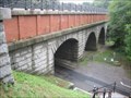
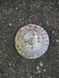
 view gallery view gallerySE1 km | Massachusetts DPW 10004 - Needham, MA in U.S. Benchmarks This Mass. DPW survey disk is located on an iron railroad bridge that spans Mass. SR 128/I-95. posted by: NorStar location: Massachusetts date approved: 03/13/2009 last visited: never |
 view gallery view gallerySE1 km | US C&GS Disk M 128 AU - Needham, MA in U.S. Benchmarks This disk sits at the end of a railroad trestle bridge with another survey disk. posted by: NorStar location: Massachusetts date approved: 03/17/2009 last visited: never |
 view gallery view galleryE1.1 km |  Newton Upper Falls - Newton Upper Falls, Massachusetts USA Newton Upper Falls - Newton Upper Falls, Massachusetts USA
in Artistically Decorated Utility Boxes The utility box at the corner of Chestnut and Elliot streets in Newton Upper Falls, Massachusetts, is vinyl wrapped in homage to the town's historic Echo Bridge with a tranquil century-old image of the span crossing the Charles River. posted by: 401Photos location: Massachusetts date approved: 04/11/2019 last visited: never |
 view gallery view galleryNE1.1 km |  Echo Bridge - Newton MA Echo Bridge - Newton MA
in U.S. National Register of Historic Places Echo Bridge is a historic masonry bridge spanning the Charles River between Needham to Newton Upper Falls, Massachusetts, and Ellis Street in Newton. posted by: nomadwillie location: Massachusetts date approved: 08/20/2019 last visited: never |
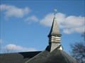 view gallery view galleryNW1.3 km | Wellesley Water Dept. Cupola/MY5554 - Wellesley, MA in U.S. Benchmarks This cupola is part of a Victorian era waterworks building, near I-95/Route 128, and is topped by a wind vane. posted by: NorStar location: Massachusetts date approved: 02/28/2010 last visited: never |
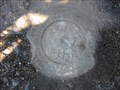
 view gallery view galleryNW1.3 km | Disk No. 10006/MY5429 - Wellesley, MA in U.S. Benchmarks This survey disk sits next to busy I-95, but it is accessible from Barton Road and is near a neat looking waterworks building. posted by: NorStar location: Massachusetts date approved: 02/28/2010 last visited: 03/08/2010 |
 view gallery view gallerySE1.3 km | Mass. Dept. Public Works 10003 - Needham, MA in U.S. Benchmarks This Massachusetts DPW marker is located on the Highland Avenue Bridge over I-95/MA SR-128 on the eastbound side. posted by: NorStar location: Massachusetts date approved: 03/13/2009 last visited: never |
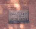 view gallery view galleryNW1.3 km |  1884 - Wellesley Water Works - Wellesley, MA 1884 - Wellesley Water Works - Wellesley, MA
in Dated Buildings and Cornerstones This stone is on the end of a brick building that is used in the municipal water works. posted by: NorStar location: Massachusetts date approved: 03/01/2010 last visited: never |
 view gallery view galleryE1.3 km |  Newton Upper Falls, MA 02464 Newton Upper Falls, MA 02464
in U.S. Post Offices Located at 81 Oak Street, Newton Upper Fls, MA posted by: nomadwillie location: Massachusetts date approved: 05/22/2011 last visited: 07/11/2010 |
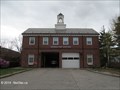 view gallery view gallery S1.4 km S1.4 km
|  Needham Fire Dept. Sta. 2 Needham Fire Dept. Sta. 2
in Firehouses This station covers the northern and eastern portion of the town of Needham. posted by: NorStar location: Massachusetts date approved: 05/17/2014 last visited: never |
|