 view gallery view gallery S0 km S0 km
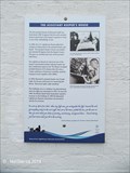
|   The Assistant Keeper's House - Beavertail State Park - Jamestown, RI The Assistant Keeper's House - Beavertail State Park - Jamestown, RI
in Rhode Island Historical Markers The Assistant Keeper's House at Beavertail Light was used for that purpose from 1898 to 1972 and is now a museum. posted by:  NorStar NorStar location: Rhode Island date approved: 07/03/2014 last visited: 10/15/2016 |
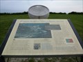
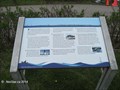 view gallery view galleryS0 km |  Beavertail Light Lookout Point , Beavertail State Park - Jamestown, RI Beavertail Light Lookout Point , Beavertail State Park - Jamestown, RI
in Orientation Tables This table marks the important landmarks along the western shore that defines Narragansett Bay. posted by: NorStar location: Rhode Island date approved: 07/03/2014 last visited: 06/02/2019 |
 view gallery view gallery SE0.2 km SE0.2 km
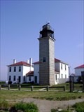
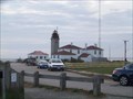
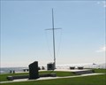
|  Beavertail Light Beavertail Light
in Coastal Lighthouses The Beavertail Light is a 45 foot square granite tower, with a rotating white beacon, located on the southern end of Conanicut Island. posted by: car2 location: Rhode Island date approved: 07/17/2008 last visited: 05/05/2022 |
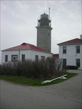 view gallery view gallerySE0.2 km |  Beavertail Light - Jamestown RI Beavertail Light - Jamestown RI
in U.S. National Register of Historic Places The dwelling that houses the museum was built in 1898 to house an assistant keeper, who helped with fog signal duties. Restoration of the lighthouse started in 1983 and continued after the BLMA members opened it as a museum in 1989. posted by: nomadwillie location: Rhode Island date approved: 12/21/2008 last visited: 06/18/2022 |
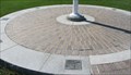
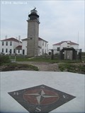 view gallery view galleryS0.2 km |  Beavertail Light Compass Rose - Jamestown, RI Beavertail Light Compass Rose - Jamestown, RI
in Compass Roses This compass rose is located on the foundation of the old light house tower, right at the point looking out toward the Atlantic Ocean. posted by: NorStar location: Rhode Island date approved: 06/26/2014 last visited: 05/05/2022 |
 view gallery view gallery N0.6 km N0.6 km
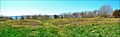
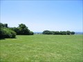
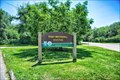
|  Beavertail State Park - Rhode Island Beavertail State Park - Rhode Island
in State/Provincial Parks Beavertail State Park, located in Jamestown, Rhode Island, is known for offering some of the most beautiful vistas along the New England coastline. The Park attracts people from all over the country to enjoy it's pristine environment. posted by:  RIclimber RIclimber location: Rhode Island date approved: 11/09/2009 last visited: 06/02/2019 |
 view gallery view galleryN3.4 km | Conanicut Battery - Jamestown RI in U.S. National Register of Historic Places Land owned by Benedict Arnold, Conanicut Battery was built by the Americans to protect entrance to Narragansett Bay and was taken over by the British in 1776. posted by: nomadwillie location: Rhode Island date approved: 04/30/2013 last visited: 07/21/2022 |
 view gallery view gallery E3.7 km E3.7 km
| Brenton Point State Park - Rhode Island in State/Provincial Parks Occupying the former grounds of one of Newport's grandest estates, Brenton Point State Park affords its visitors one of the most commanding and spectacular views on the East Coast. posted by: RIclimber location: Rhode Island date approved: 11/09/2009 last visited: 09/03/2022 |
 view gallery view galleryE3.7 km |  Portuguese Discovery Monument - Brenton Point, RI Portuguese Discovery Monument - Brenton Point, RI
in Vasco da Gama A beautiful oceanfront monument celebrating Portuguese navigators. posted by: Mountain_Wanderer location: Rhode Island date approved: 01/09/2006 last visited: 06/08/2022 |
 view gallery view galleryE3.7 km |  Portuguese Navigators Monument Portuguese Navigators Monument
in Portuguese Historical Markers The purpose of the monument is to recognize the contributions of the Portuguese to the exploration of the world and to the science of navigation, and to honor all Americans of Portuguese descent. posted by: Go Boilers! location: Rhode Island date approved: 08/25/2011 last visited: 10/01/2022 |
 view gallery view galleryE3.7 km | Brenton Point Compass Rose - Newport, RI in Compass Roses A compass rose at a nautical flag pole posted by: ODragon location: Rhode Island date approved: 09/30/2008 last visited: 09/03/2022 |
 view gallery view galleryE3.7 km |  Brenton Point Maritime Memorial - Newport, RI Brenton Point Maritime Memorial - Newport, RI
in Maritime Monuments and Memorials A large monument... posted by: ODragon location: Rhode Island date approved: 09/26/2008 last visited: 09/03/2022 |
 view gallery view galleryE3.7 km |  Brenton Point Nautical Flag - Newport, RI Brenton Point Nautical Flag - Newport, RI
in Nautical Flag Poles A nautical flag pole in a state park. posted by: ODragon location: Rhode Island date approved: 09/26/2008 last visited: 09/03/2022 |
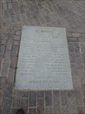
 view gallery view galleryE3.7 km |  Brenton Point Pavers - Newport, RI Brenton Point Pavers - Newport, RI
in Donated Engraved Bricks and Pavers Pavers at a multi-memorial. posted by: ODragon location: Rhode Island date approved: 09/26/2008 last visited: 05/26/2019 |
 view gallery view galleryE3.7 km | S/V Marques - Brenton Point, RI in Maritime Monuments and Memorials Simple marker dedicated to the crew of the S/V Marques lost with 19 of 28 hands in 1984. posted by: jiggs11 location: Rhode Island date approved: 10/12/2019 last visited: 09/03/2022 |
 view gallery view galleryE3.7 km |  Egyptair 990 - Brenton Point, RI Egyptair 990 - Brenton Point, RI
in Plane Crash Sites Marker dedicated to the 217 passengers and crew of Egyptair Flight 990, which crashed off the coast in 1999. posted by: jiggs11 location: Rhode Island date approved: 09/24/2019 last visited: 09/03/2022 |
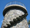 view gallery view galleryE3.9 km |  Brenton Point Look Out Tower - Newport, RI Brenton Point Look Out Tower - Newport, RI
in Look-Out Towers An old stone look out tower. posted by: ODragon location: Rhode Island date approved: 09/28/2008 last visited: 06/21/2016 |
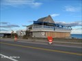
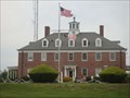 view gallery view galleryE3.9 km |  US Coast Guard Station Castle Hill - Newport, RI US Coast Guard Station Castle Hill - Newport, RI
in Lifeboats and Rescue Stations Main Coast Guard station responsible for the Newport area. posted by: jiggs11 location: Rhode Island date approved: 09/24/2019 last visited: never |
 view gallery view gallery NE4.5 km NE4.5 km
| Fort Wetherill State Park -- Jamestown RI in State/Provincial Parks Fort Wetherill State Park, situated upon 100 foot high granite cliffs across the water from Fort Adams State Park. posted by: nomadwillie location: Rhode Island date approved: 07/30/2017 last visited: never |
 view gallery view galleryNE4.8 km |  1908 - Fort Wetherill Mine House - Jamestown RI 1908 - Fort Wetherill Mine House - Jamestown RI
in Dated Buildings and Cornerstones Located just below on the waterfront facing Fort Adams, these three buildings, all 1908, were storage buildings. posted by: nomadwillie location: Rhode Island date approved: 07/31/2017 last visited: 04/24/2019 |
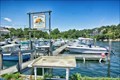 view gallery view galleryNE4.8 km |  Fort Wetheril Boat Association - Jamestown RI Fort Wetheril Boat Association - Jamestown RI
in Marinas Small marina at the docks of Fort Wetherill State Park. posted by: nomadwillie location: Rhode Island date approved: 08/02/2017 last visited: never |
 view gallery view gallery NW4.8 km NW4.8 km
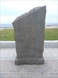
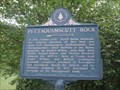
| Pettaquamscutt Rock - South Kingstown, RI in Rhode Island Historical Markers Pettaquamscutt Rock - South Kingstown, RI posted by: RIclimber location: Rhode Island date approved: 11/26/2009 last visited: 08/22/2011 |
 view gallery view galleryNW5.1 km |  Pettaquamscutt Rock - Narragansett, RI Pettaquamscutt Rock - Narragansett, RI
in Established Rock Climbing Areas Here at Treaty Rock Roger Williams and William Coddington probably completed purchase of Providence and Aquidneck, March 24, 1637-8, and the Atherton Company in 1662 forclosed its morgage on the Narragansett lands. posted by: RIclimber location: Rhode Island date approved: 12/09/2009 last visited: 04/16/2011 |
 view gallery view gallery SW5.1 km SW5.1 km
|  Rhode Island Coastal Communities Hit Hard by Sandy - Narragansett, RI Rhode Island Coastal Communities Hit Hard by Sandy - Narragansett, RI
in News Article Locations In Narragansett Bay, damage from Hurricane Sandy was seen that included the U. S. Coast Guard House and seawall in Narragansett, and bluffs, trees, and houses elsewhere. posted by: NorStar location: Rhode Island date approved: 11/20/2012 last visited: 06/05/2017 |
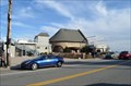 view gallery view gallerySW5.1 km | Narragansett Pier Life Saving Station - Narragansett RI in U.S. National Register of Historic Places What was once a life saving station along the Atlantic Ocean is now a fine restaurant. Also known as Coast Guard House posted by: nomadwillie location: Rhode Island date approved: 02/20/2012 last visited: 06/05/2017 |
|