 view gallery view gallery SE29 km SE29 km
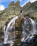
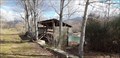
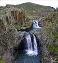
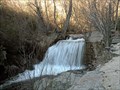
|   Cascada de los Litueros (o de Somosierra) Cascada de los Litueros (o de Somosierra)
in Waterfalls La cascada o chorrera de los Litueros pasa por ser la más alta de la Comunidad de Madrid. posted by:  monticola monticola location: Comunidad de Madrid, Spain date approved: 07/08/2008 last visited: 09/14/2019 |
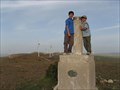
 view gallery view gallery S35.1 km S35.1 km
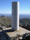
|  Las Berrocosas Las Berrocosas
in Vértices Geodésicos Se encuentra en una de las cumbres secundarias de los montes Carpetanos que por poco no alcanza los 2000 metros. posted by: monticola location: Comunidad de Madrid, Spain date approved: 05/24/2011 last visited: 08/03/2010 |
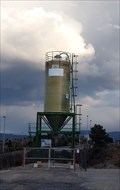
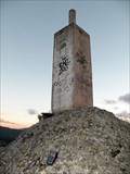
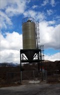 view gallery view gallerySE40.1 km |  M-137 Km12 - Prádena de Rincón, Madrid, España M-137 Km12 - Prádena de Rincón, Madrid, España
in Solitary Silos Silo de vialidad invernal // Winter road silo posted by:  xeocach xeocach location: Comunidad de Madrid, Spain date approved: 03/12/2023 last visited: never |
 view gallery view gallery NW40.4 km NW40.4 km
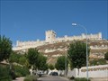
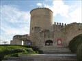
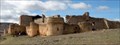
|  Peñafiel Castle - Valladolid, Spain Peñafiel Castle - Valladolid, Spain
in Castles Peñafiel's castle adapts to the narrow and long hill on the one that settles itself in the locality of the same name, in the province of Valladolid, to 56 kilometres of his capital. posted by: jcast location: Castilla y León, Spain date approved: 11/12/2006 last visited: 04/01/2018 |
 view gallery view gallerySE40.4 km |  Laguna del Salmoral - Prádena del Rincón, Madrid, España Laguna del Salmoral - Prádena del Rincón, Madrid, España
in Birdwatching Locations Observatorio de aves en la Laguna del Salmoral // Bird observatory in the Salmoral Lake posted by: xeocach location: Comunidad de Madrid, Spain date approved: 08/13/2023 last visited: never |
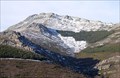
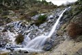 view gallery view galleryS40.7 km | Chorrera de San Mamés in Waterfalls Una de las cascadas de mayor altura en la Comunidad de Madrid posted by: monticola location: Comunidad de Madrid, Spain date approved: 05/07/2008 last visited: never |
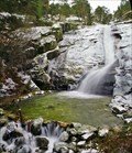 view gallery view galleryS41.2 km | El Chorro de Navafría in Waterfalls La más conocida de las chorreras o chorrancas que abundan en los cursos de agua de la cara septentrional del Guadarrama. The best known of the many waterfalls that make up the watercourses of the northern face of the Guadarrama. posted by: monticola location: Castilla y León, Spain date approved: 02/02/2010 last visited: 07/25/2009 |
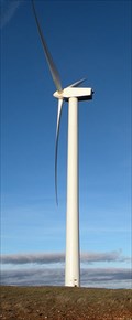
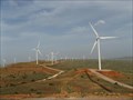 view gallery view gallery E43.5 km E43.5 km
|  Guadalajara-Segovia Guadalajara-Segovia
in Windmills These windmills are in a eolic Park between Guadalajara and Segovia in the roud N-110 posted by: jcast location: Spain date approved: 05/28/2006 last visited: never |
 view gallery view galleryE43.8 km | Parque Eólico Cantalojas in Windmills Gran parque eólico situado en torno al alto de Rivilla (1506 m) posted by: monticola location: Spain date approved: 03/08/2009 last visited: never |
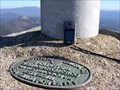
 view gallery view galleryE43.9 km | Rivilla (Guadalajara) in Vértices Geodésicos Situado en lo más alto del cerro del mismo nombre, sobre un terreno en el que hay un parque eolico, en el mojón límite de las provincias de Soria, Segovia y Guadalajara. posted by: jcast location: Spain date approved: 05/28/2006 last visited: never |
 view gallery view gallerySE45.1 km | Peña de la Cabra in Vértices Geodésicos La Peña de la Cabra (1830m) forma un brusco resalte en la cuerda que se inicia en el puerto de la Puebla. posted by: monticola location: Spain date approved: 02/11/2008 last visited: never |
 view gallery view galleryS45.9 km | Pico del Nevero (Pinilla del Valle, Madrid) in Vértices Geodésicos Situado en la Sierra de Guadarrama, en el pico de Nevero, en terreno de rocas. posted by: jcast location: Spain date approved: 08/10/2008 last visited: 05/22/2011 |
 view gallery view gallerySE48 km | La Tornera (Madrid) in Vértices Geodésicos Vértice situado en la máxima cota de la Sierra de la Puebla o del Lobosillo. posted by: monticola location: Spain date approved: 02/11/2008 last visited: never |
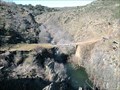 view gallery view gallerySE49.1 km |  Puente de Matallana Puente de Matallana
in Hiking Path Footbridges Puente sobre el río Jarama en el camino entre las localidades de Matallana y Roblelacasa (Guadalajara) posted by: monticola location: Spain date approved: 02/15/2009 last visited: never |
 view gallery view galleryS49.2 km | A-1 km69 - Lozoyuela, Madrid, España in Solitary Silos Silo de vialidad invernal // Winter road silo posted by: xeocach location: Comunidad de Madrid, Spain date approved: 03/12/2023 last visited: never |
 view gallery view gallerySE49.7 km | Cascada del Aljibe in Waterfalls Una de las cascadas menos conocidas y a la vez más bonitas de Guadalajara posted by: monticola location: Castilla-La Mancha, Spain date approved: 02/15/2009 last visited: never |
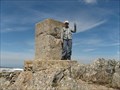
 view gallery view gallerySE49.7 km | Ocejón in Vértices Geodésicos Vértice situado en la cumbre más emblemática de Guadalajara y el "dosmil" más oriental del Sistema Central. posted by: monticola location: Castilla-La Mancha, Spain date approved: 10/05/2009 last visited: never |
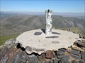
 view gallery view gallerySE49.7 km |  Pico Ocejón Pico Ocejón
in Mountain Summits El Ocejón es la cumbre más representativa de este sector del Sistema Central. Summit Ocejón is more representative of this sector of the Central System. posted by: monticola location: Castilla-La Mancha, Spain date approved: 10/06/2009 last visited: never |
 view gallery view gallery W49.7 km W49.7 km
| Cuellar, Segovia, Spain in Castles Cuellar's castle isplaced in the Cuéllar's highest part, province of Segovia, closing for this place the enclosure walled of the villa. posted by: jcast location: Castilla y León, Spain date approved: 11/12/2006 last visited: 11/12/2006 |
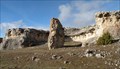
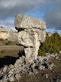 view gallery view galleryE50.1 km |  Seta en Campisábalos Seta en Campisábalos
in Nature's Balanced Rocks Resto aislado por la erosión de las masas de rocas carbonatadas de la zona. posted by: monticola location: Spain date approved: 03/27/2009 last visited: never |
 view gallery view galleryE50.1 km |  Menhir de Campisábalos Menhir de Campisábalos
in Megalithic Monuments Menhir situado en una depresión kárstica en forma de plaza. posted by: monticola location: Spain date approved: 03/15/2009 last visited: never |
 view gallery view gallerySE50.5 km | Centenera (Madrid) in Vértices Geodésicos El pico Centenera (1809m) constituye el extremo sur de la sierra de la Puebla o del Lobosillo. posted by: monticola location: Spain date approved: 02/11/2008 last visited: never |
 view gallery view gallerySE51.5 km |  Arroyo Vallosera Arroyo Vallosera
in Man-made Waterfalls Pequeño salto sobre una antigua presa para alimentar un canal posted by: monticola location: Spain date approved: 02/19/2009 last visited: never |
 view gallery view gallerySE51.8 km | Picurucho in Vértices Geodésicos Situado junto a la carretera, entre las localidades de Valdepinillos y La Huerce (Guadalajara) posted by: monticola location: Castilla-La Mancha, Spain date approved: 03/09/2009 last visited: never |
 view gallery view galleryE52.5 km | Castillo de Caracena in Castles Situado en una elevación al suroeste del casco urbano de Caracena (Soria, Castilla y León), forma parte del rico conjunto medieval de la localidad. posted by: monticola location: Castilla y León, Spain date approved: 03/19/2009 last visited: never |
|