 view gallery view gallery W12.4 km W12.4 km
|   Coming Together at Big Lagoon - California Coming Together at Big Lagoon - California
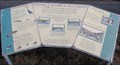
in Flora and Fauna Information Signs Flora and Fauna sign at Big Lagoon County Park. posted by:  Volcanoguy Volcanoguy location: California date approved: 02/12/2014 last visited: 09/23/2013 |
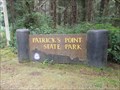 view gallery view galleryW14.6 km |  Patrick’s Point State Park - California Patrick’s Point State Park - California
in State/Provincial Parks Patrick’s Point State Park on the northern California Coast, 25 miles north of Eureka and 56 miles south of Crescent City. posted by: Volcanoguy location: California date approved: 01/30/2014 last visited: 04/12/2023 |
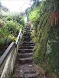 view gallery view galleryW14.8 km |  Ceremonial Rock Stairs - Patrick’s Point State Park - California Ceremonial Rock Stairs - Patrick’s Point State Park - California
in Outdoor Stairways Stairway to top of Ceremonial Rock in Patrick’s Point State Park. posted by: Volcanoguy location: California date approved: 02/04/2014 last visited: 09/22/2013 |
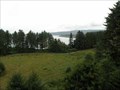 view gallery view galleryW14.8 km |  Ceremonial Rock - Patrick’s Point State Park - California Ceremonial Rock - Patrick’s Point State Park - California
in Scenic Overlooks Ceremonial Rock Overlook in Patrick’s Point State Park. posted by: Volcanoguy location: California date approved: 02/01/2014 last visited: 09/22/2013 |
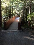
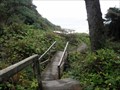 view gallery view galleryW15 km |  Footbridges - Mussel Rocks Trail - Patrick’s Point S.P. - California Footbridges - Mussel Rocks Trail - Patrick’s Point S.P. - California
in Hiking Path Footbridges Pair of footbridges on Mussel Rocks Trail. posted by: Volcanoguy location: California date approved: 02/01/2014 last visited: 09/22/2013 |
 view gallery view gallery NW15 km NW15 km
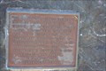
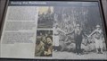
|  Big Diamond, a Circus Elephant Big Diamond, a Circus Elephant
in E Clampus Vitus Historical Markers Marker commemorating poor Big Diamond and the confusion discovery of his bones caused... posted by: Tygress location: California date approved: 05/19/2011 last visited: 09/07/2012 |
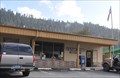 view gallery view galleryNW15.1 km |  Orick, California 95555 Orick, California 95555
in U.S. Post Offices This Post Office is located at 121147 Highway 101 in Orick, California. posted by: brwhiz location: California date approved: 01/01/2012 last visited: never |
 view gallery view galleryW15.1 km |  LV1165 - NGS PIN 1927 NO 2 1974 - California LV1165 - NGS PIN 1927 NO 2 1974 - California
in U.S. Benchmarks National Geodetic Survey reference mark for LV1165. posted by: Volcanoguy location: California date approved: 02/01/2014 last visited: 11/20/2023 |
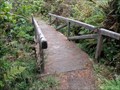 view gallery view galleryW15.3 km | Footbridge - Rocky Point Trail - Patrick’s Point S.P. - California in Hiking Path Footbridges Footbridge on Rocky Point Trail. posted by: Volcanoguy location: California date approved: 02/01/2014 last visited: 09/22/2013 |
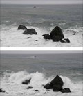 view gallery view galleryW15.4 km |  Rocky Point - Patrick’s Point S.P. - California Rocky Point - Patrick’s Point S.P. - California
in Wavy Places Rocky Point at Patrick’s Point S.P. posted by: Volcanoguy location: California date approved: 02/01/2014 last visited: 09/22/2013 |
 view gallery view gallery N15.4 km N15.4 km
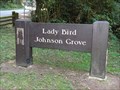
|  Lady Bird Johnson Grove Trailhead - California Lady Bird Johnson Grove Trailhead - California
in Hiking and walking trailheads Trailhead for the Lady Bird Johnson Grove in the Redwoods National and State Parks, California. posted by: Volcanoguy location: California date approved: 01/07/2013 last visited: 09/24/2012 |
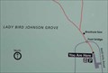 view gallery view galleryN15.4 km |  Lady Bird Johnson Grove - California Lady Bird Johnson Grove - California
in 'You Are Here' Maps You are Here marker at the Lady Bird Johnson Grove trailhead. posted by: Volcanoguy location: California date approved: 01/07/2013 last visited: 09/24/2012 |
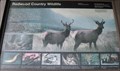 view gallery view galleryN15.4 km | Redwood Country Wildlife - California in Flora and Fauna Information Signs Flora and Fauna sign at the beginning of the trail to Lady Bird Johnson Grove. posted by: Volcanoguy location: California date approved: 01/15/2013 last visited: 09/25/2012 |
 view gallery view galleryN15.4 km | Bridge to Lady Bird Johnson Grove - California in Hiking Path Footbridges Footbridge at beginning of the trail to Lady Bird Johnson Grove. posted by: Volcanoguy location: California date approved: 01/07/2013 last visited: 09/24/2012 |
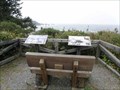 view gallery view galleryW15.6 km | Palmers Point South - Patrick’s Point S.P. - California in Flora and Fauna Information Signs South group of signs at Palmers Point. posted by: Volcanoguy location: California date approved: 02/02/2014 last visited: 04/12/2023 |
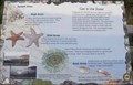 view gallery view galleryW15.6 km | Palmers Point North - Patrick’s Point S.P. - California in Flora and Fauna Information Signs North group of signs at Palmers Point. posted by: Volcanoguy location: California date approved: 02/02/2014 last visited: 09/22/2013 |
 view gallery view galleryN15.8 km |  Orick, California ~ Population 650 Orick, California ~ Population 650
in Population Signs This combination Population/Elevation Sign is on the west side of US Highway 101 as you enter Orick from the north. posted by: brwhiz location: California date approved: 12/13/2012 last visited: never |
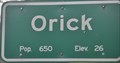 view gallery view galleryN15.8 km |  Orick, California ~ Elevation 26 Feet Orick, California ~ Elevation 26 Feet
in Elevation Signs This combination Population/Elevation Sign is on the west side of US Highway 101 as you enter Orick from the north. posted by: brwhiz location: California date approved: 12/13/2012 last visited: never |
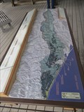 view gallery view galleryNW16.1 km |  Redwood Creek Watershed - Orick, California Redwood Creek Watershed - Orick, California
in 3D Map Models of Our World and Beyond A 3D model of the Redwood Creek Watershed can be found on the porch of the Kuchel Visitor Center in Redwoods National Park near Orick. It shows the mountainous area that Redwoods National Park is located in. posted by: DougK location: California date approved: 09/07/2013 last visited: 07/10/2016 |
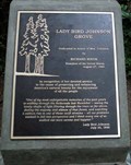 view gallery view galleryN16.1 km |  Lady Bird Johnson Lady Bird Johnson
in Citizen Memorials Memorial to Lady Bird Johnson in Redwoods National and State Parks. posted by: Volcanoguy location: California date approved: 01/08/2013 last visited: 09/25/2012 |
 view gallery view galleryN16.1 km |  Saving the Redwoods - California Saving the Redwoods - California
in Signs of History History sign at the Lady Bird Johnson Grove. posted by: Volcanoguy location: California date approved: 01/08/2013 last visited: 09/25/2012 |
 view gallery view gallery SW16.3 km SW16.3 km
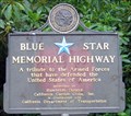
|  Rest Area along Highway 101, near Trinidad, CA Rest Area along Highway 101, near Trinidad, CA
in Blue Star Memorial Highway Markers This Blue Star Memorial Highway Marker is found at a Highway 101 Rest Area. posted by: Mauison location: California date approved: 07/29/2007 last visited: 09/14/2012 |
 view gallery view gallerySW17.5 km | Trinidad, California ~ Elevation 175 Feet in Elevation Signs This combination Population/Elevation Sign is on the west side of the US Highway 101 Exit 728 southbound offramp as you enter Trinidad from the north. posted by: brwhiz location: California date approved: 12/13/2012 last visited: 06/05/2020 |
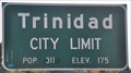 view gallery view gallerySW17.5 km | Trinidad, California ~ Population 311 in Population Signs This combination Population/Elevation Sign is on the west side of the US Highway 101 Exit 728 southbound offramp as you enter Trinidad from the north. posted by: brwhiz location: California date approved: 12/13/2012 last visited: 06/04/2020 |
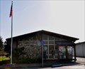 view gallery view gallerySW17.5 km | Trinidad, California 95570 in U.S. Post Offices This Post Office is located at 357 Main Street in Trinidad, California. posted by: brwhiz location: California date approved: 01/01/2012 last visited: never |
|