 view gallery view gallery NE15.6 km NE15.6 km
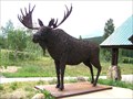
|   Moose- Colorado State Forest Moose- Colorado State Forest
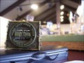
in Figurative Public Sculpture This life sized moose sculpture displays an unusual construction. posted by:  NevaP NevaP location: Colorado date approved: 10/17/2007 last visited: 06/23/2014 |
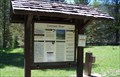
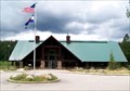 view gallery view galleryNE15.6 km |  Moose visitor Center: Colorado state Forest State Park Moose visitor Center: Colorado state Forest State Park
in Tourist Information Centers - Visitor Centers This visitor center is on highway 14 about a mile east of Gould, Colorado. posted by: NevaP location: Colorado date approved: 10/17/2007 last visited: 06/25/2014 |
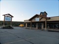 view gallery view galleryNE21.6 km |  ReStore - Silverthorne, CO ReStore - Silverthorne, CO
in Habitat ReStores This ReStore is found in the Summit County area between Dillon, Frisco and Silverthorne. posted by:  Outspoken1 Outspoken1 location: Colorado date approved: 10/08/2013 last visited: never |
 view gallery view gallery E28.6 km E28.6 km
|  You Are Here - Colorado River Trailhead - Rocky Mountains National Park, CO You Are Here - Colorado River Trailhead - Rocky Mountains National Park, CO
in 'You Are Here' Maps The Colorado River Trail is nearly a water level trail, only 350' of elevation gain. The southern end of the trail is at a parking area off US Hwy 34. Beginning elevation is about 9000'. posted by: hummerstation location: Colorado date approved: 07/29/2014 last visited: never |
 view gallery view galleryE28.6 km |  Colorado River Trailhead - Rocky Mountains National Park, CO Colorado River Trailhead - Rocky Mountains National Park, CO
in Hiking and walking trailheads The Colorado River Trail is the most popular trailhead in the less scenic western half of Rocky Mountain National Park. posted by: hummerstation location: Colorado date approved: 01/01/2015 last visited: never |
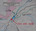
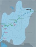 view gallery view galleryE28.6 km | You Are Here - Colorado River - Rocky Mountains National Park, CO in 'You Are Here' Maps Map showing the entire Colorado River drainage from Rocky Mountain National Park to the Gulf of California. The map is about 10 miles south of the river's source. The river is about 30' wide just above the sign. posted by: hummerstation location: Colorado date approved: 07/29/2014 last visited: never |
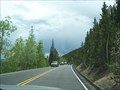
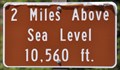 view gallery view galleryE31.1 km |  Trail Ridge Road ~ Two Miles Above Sea Level Trail Ridge Road ~ Two Miles Above Sea Level
in Elevation Signs This Elevation Sign is located on the north side of Trail Ridge Road (US Highway 34) about 16.5 miles north of Grand Lake, Colorado. posted by: brwhiz location: Colorado date approved: 02/10/2013 last visited: 07/19/2017 |
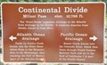 view gallery view galleryE31.4 km | Continental Divide/Milner Pass ~ Elevation 10,759 Feet in Elevation Signs This Elevation is inscribed on the Continental Divide/Milner Pass Sign located on the east side of Trail Ridge Road (US Highway 34) at the summit of Milner Pass. posted by: brwhiz location: Colorado date approved: 02/10/2013 last visited: 09/03/2020 |
 view gallery view galleryE31.4 km | Old Fall River Roadway in Hiking and walking trailheads This Hiking and Walking Trailhead is located at a turnout on the southeast side of US Highway 34 (Trail Ridge Road) at the summit of Milner Pass and the Continental Divide in Rocky Mountain National Park, Colorado. posted by: brwhiz location: Colorado date approved: 03/08/2013 last visited: never |
 view gallery view galleryE31.4 km | Milner Pass ~ Elevation 10,750 Feet in Elevation Signs This Elevation Sign inscribed on the Milner Pass Information Sign located on the east side of Trail Ridge Road (US Highway 34) at the summit of Milner Pass. posted by: brwhiz location: Colorado date approved: 02/10/2013 last visited: 10/09/2016 |
 view gallery view galleryE31.4 km | Milner Pass Summit in 'You Are Here' Maps You Are Here on the southwest end of Poudre Lake at the summit of Milner Pass in Rocky Mountain National Park. posted by: brwhiz location: Colorado date approved: 08/29/2013 last visited: 06/08/2014 |
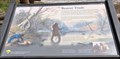 view gallery view galleryE31.4 km |  Beaver Trade ~ Rocky Mountain National Park, Colorado Beaver Trade ~ Rocky Mountain National Park, Colorado
in Colorado Historical Markers This Historical Marker is mounted on a steel post at a turnout on the southeast side of US Highway 34 (Trail Ridge Road) at the summit of Milner Pass and the Continental Divide in Rocky Mountain National Park, Colorado. posted by: brwhiz location: Colorado date approved: 02/08/2013 last visited: never |
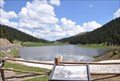 view gallery view galleryE31.4 km |  Poudre Lake ~ Colorado, USA Poudre Lake ~ Colorado, USA
in Natural Lakes The best place to view this lovely alpine lake is a parking lot on the southeast side of US Highway 34 (Trail Ridge Road) at the summit of Milner Pass and the Continental Divide in Rocky Mountain National Park, Colorado. posted by: brwhiz location: Colorado date approved: 02/07/2013 last visited: 10/09/2016 |
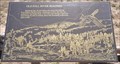
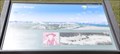
 view gallery view galleryE34.8 km |  Volcanoes of the Never Summer Mountains Volcanoes of the Never Summer Mountains
in Places of Geologic Significance This interpretive sign about the Never Summer Mountains is located in a turnout on the southwest side of Trail Ridge Road (US Highway 34) a short distance southwest of the Alpine Visitor Center of Rocky Mountain National Park. posted by: brwhiz location: Colorado date approved: 02/07/2013 last visited: never |
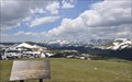
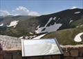
 view gallery view galleryE34.9 km |  Gore Range Orientation Table Gore Range Orientation Table
in Orientation Tables This Orientation Table is located on the southwest side of US Highway 34 (Trail Ridge Road) southwest of the Alpine Visitor Center and just west of the highest point of Trail Ridge Road. posted by: brwhiz location: Colorado date approved: 03/08/2013 last visited: 10/09/2016 |
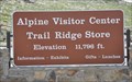 view gallery view galleryE35.9 km | Alpine Visitor Center ~ Elevation 11,796 Feet in Elevation Signs This Elevation is inscribed on the Alpine Visitor Center/Trail Ridge Store Sign located on the east side of Trail Ridge Road (US Highway 34) near the summit of Trail Ridge Road. posted by: brwhiz location: Colorado date approved: 02/10/2013 last visited: 06/23/2018 |
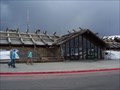
 view gallery view galleryE35.9 km |  Alpine Ranger Station/Visitor Center, Rocky Mountain Nat'l Park, CO Alpine Ranger Station/Visitor Center, Rocky Mountain Nat'l Park, CO
in Ranger Stations The highest ranger station in the US National Park system at 11796 ft above sea level. posted by:  ronjean ronjean location: Colorado date approved: 06/17/2010 last visited: 09/26/2019 |
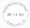
 view gallery view galleryE36 km |  Alpine Visitor Center - Rocky Mountain National Park, CO Alpine Visitor Center - Rocky Mountain National Park, CO
in NPS Passport Cancellation Stations Don't pass out at this 11,796 ft above sea level NPS Passport Cancellation Station. posted by: Big B Bob location: Colorado date approved: 06/23/2008 last visited: 09/26/2019 |
 view gallery view galleryE36 km |  Trail Ridge Road - Rocky Mountain National Park, Colorado Trail Ridge Road - Rocky Mountain National Park, Colorado
in U.S. National Register of Historic Places Trail Ridge Road is the highest continuous highway in the United States. posted by: Big B Bob location: Colorado date approved: 11/18/2009 last visited: 09/26/2019 |
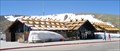
 view gallery view galleryE36 km |  Trail Ridge Road - Alpine Visitor Center - Rocky Mountain National Park, Colorado Trail Ridge Road - Alpine Visitor Center - Rocky Mountain National Park, Colorado
in National Scenic Byways Trail Ridge Road is America's highest continuously paved road. Besides the visitor center, there is a gift shop and a short trail to an overlook at 12,003 feet. posted by: Big B Bob location: Colorado date approved: 11/14/2009 last visited: 07/16/2017 |
 view gallery view galleryE36 km | Glacial Cirque in Places of Geologic Significance You can get a close-up view of this glacial cirque from the observation deck at the Alpine Visitor Center in Rocky Mountain National Park near the high point of Trail Ridge Road (US Highway 34). posted by: brwhiz location: Colorado date approved: 02/07/2013 last visited: 09/26/2019 |
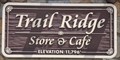 view gallery view galleryE36 km | Trail Ridge Store and Café ~ Elevation 11,796 Feet in Elevation Signs This Elevation Sign is mounted on the west face of the Trail Ridge Store and Café on the east side of Trail Ridge Road (US Highway 34) near the summit of Trail Ridge Road. posted by: brwhiz location: Colorado date approved: 02/10/2013 last visited: 06/23/2018 |
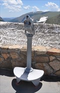 view gallery view galleryE36 km |  RMNP Alpine Visitor Center Monocular RMNP Alpine Visitor Center Monocular
in Coin-Op Binoculars This Coin-Operated Monocular is located on the observation deck at the Alpine Visitor Center in Rocky Mountain National Park near the high point of Trail Ridge Road (US Highway 34). posted by: brwhiz location: Colorado date approved: 02/07/2013 last visited: 06/26/2016 |
 view gallery view gallery SE36 km SE36 km
| Rocky Mountain National Park ~ Kawuneeche Visitor Center Passport Cancellation Station in NPS Passport Cancellation Stations This NPS Passport Cancellation Station is located inside the Kawuneeche Visitor Center just inside the southwestern entrance to Rocky Mountain National Park on US Highway 34 north of Grand Lake, Colorado. posted by: brwhiz location: Colorado date approved: 02/11/2013 last visited: 06/23/2018 |
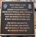 view gallery view gallerySE36 km |  U.S. Park Ranger Suzanne Elizabeth Roberts U.S. Park Ranger Suzanne Elizabeth Roberts
in Police Memorials This Police Memorial honoring a fallen National Parks Ranger is mounted on a rock monument in front of the Kawuneeche Visitor Center just inside the southwestern entrance to Rocky Mountain National Park on US Highway 34 north of Grand Lake, Colorado. posted by: brwhiz location: Colorado date approved: 02/07/2013 last visited: 10/09/2016 |
|