 view gallery view gallery W0 km W0 km
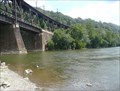
|   CONFLUENCE - Conestoga River - Susquehanna River CONFLUENCE - Conestoga River - Susquehanna River
in River Origins, Destinations and Confluences The Conestoga River meets the Susquehanna at Safe Harbor Hydroelectric Dam, Lancaster County, PA posted by:  polecat42 polecat42 location: Pennsylvania date approved: 08/11/2012 last visited: 10/05/2016 |
 view gallery view gallery NW0.5 km NW0.5 km
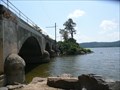
|  Safe Harbor Hydroelectric Plant - York/Lancaster Counties, PA Safe Harbor Hydroelectric Plant - York/Lancaster Counties, PA
in American Guide Series The plants dam is 4,869 feet long and 75 feet high. Behind the dam is 7,360-acre Lake Clark, a popular boating and recreation area. The first power was generated on December 7, 1931. posted by:  Math Teacher Math Teacher location: Pennsylvania date approved: 07/17/2009 last visited: 10/05/2016 |
 view gallery view gallery SW0.8 km SW0.8 km
|  Safe Harbor - York County, PA Safe Harbor - York County, PA
in Water Dams The plants dam is 4,869 feet long and 75 feet high. Behind the dam is 7,360-acre Lake Clark, a popular boating and recreation area. Safe Harbor manages more than 2,300 acres of land in the area for soil, water, and wildlife habitat preservation. posted by: Math Teacher location: Pennsylvania date approved: 07/20/2009 last visited: 10/05/2016 |
 view gallery view gallerySW0.8 km |  Safe Harbor Dam - Lancaster/York Counties, PA Safe Harbor Dam - Lancaster/York Counties, PA
in Wikipedia Entries The plants dam is 4,869 feet long and 75 feet high. Behind the dam is 7,360-acre Lake Clark, a popular boating and recreation area. Safe Harbor manages more than 2,300 acres of land in the area for soil, water, and wildlife habitat preservation. posted by: Math Teacher location: Pennsylvania date approved: 07/17/2009 last visited: 11/08/2016 |
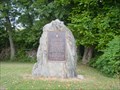 view gallery view gallery N4.2 km N4.2 km
|  Conestoga Indian Town - PLAQUE Conestoga Indian Town - PLAQUE
in Pennsylvania Historical Markers Conestoga Indians lived near here! posted by: Gosffo location: Pennsylvania date approved: 08/19/2006 last visited: 10/05/2016 |
 view gallery view gallery S4.3 km S4.3 km
| CONFLUENCE - Pequea Creek- Susquehanna River in River Origins, Destinations and Confluences Pequea Creek (pronounced peck-way) is a tributary of the Susquehanna River that runs for 49.2 miles from the eastern border of Lancaster County, Pennsylvania to the village of Pequea, about 5 miles north of Holtwood Hydroelectric Dam. posted by: polecat42 location: Pennsylvania date approved: 08/11/2012 last visited: 09/14/2014 |
 view gallery view gallery SE4.7 km SE4.7 km
|  Colemanville Covered Bridge Colemanville Covered Bridge
in U.S. National Register of Historic Places Colemanville Covered Bridge is on Pequea Campground Road (T-408), NE of Pequea, in Martic Township, Lancaster County, Pennsylvania. posted by: deano1943 location: Pennsylvania date approved: 08/24/2006 last visited: 05/26/2019 |
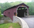 view gallery view gallerySE4.7 km |  Colemanville Covered Bridge Colemanville Covered Bridge
in Covered Bridges This bridge is located on Pequea Campground Road, (T 408), Colemanville, between Conestoga and Martic Townships, Lancaster County, Pennsylvania. posted by: deano1943 location: Pennsylvania date approved: 05/14/2006 last visited: 05/26/2019 |
 view gallery view galleryW5.3 km |  Peace Pole on Mason-Dixon Trail, York County, Pennsylvania, USA Peace Pole on Mason-Dixon Trail, York County, Pennsylvania, USA
in Peace Poles Peace Pole along Mason-Dixon Trail in York County. posted by: BethKatzPA location: Pennsylvania date approved: 12/26/2021 last visited: never |
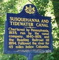 view gallery view galleryS5.6 km | Susquehanna and Tidewater Canal in Pennsylvania Historical Markers This Historical Marker is located at York Furnace, York County, Pennsylvania. posted by: deano1943 location: Pennsylvania date approved: 06/11/2006 last visited: 11/04/2018 |
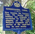 view gallery view galleryS5.6 km | Susquehanna Canal in Pennsylvania Historical Markers This Historical Marker is located at York Furnace, York County, Pennsylvania. posted by: deano1943 location: Pennsylvania date approved: 06/11/2006 last visited: 11/04/2018 |
 view gallery view galleryS6.9 km |  Ulmer-Root-Haines Memorial Park - Airville, PA Ulmer-Root-Haines Memorial Park - Airville, PA
in Public Access Lands 26 acres of absolute beauty is the best description that I can give of the Ulmer-Root-Haines Memorial Park, across from the Indian Steps Museum in Airville, PA. posted by: Janila location: Pennsylvania date approved: 11/18/2018 last visited: never |
 view gallery view galleryS6.9 km |  Indian Totem Pole, York County, Pennsylvania Indian Totem Pole, York County, Pennsylvania
in Outside Wooden Display Carvings This Totem Pole is located at the Indian Steps Museum, near Airville, in York County, Pennsylvania. posted by: deano1943 location: Pennsylvania date approved: 09/30/2006 last visited: 06/10/2018 |
 view gallery view galleryS6.9 km | Indian Steps Cabin - Indian Steps Museum in U.S. National Register of Historic Places Indian Steps Museum is located off of Rt. 425 Furnace Rd., on Indian Steps Rd., in Lower Chanceford Township, York County, Pennsylvania. posted by: deano1943 location: Pennsylvania date approved: 10/01/2006 last visited: 06/09/2018 |
 view gallery view galleryNW7.2 km |  Turkey Hill Preserve - Conestoga, PA Turkey Hill Preserve - Conestoga, PA
in Windmills As one looks south while driving across the bridges of the Susquehanna River from Wrightsville to Columbia, one can see the beautiful site of two wind turbines sitting miles away high on top of Turkey Hill in Conestoga, PA. posted by: Janila location: Pennsylvania date approved: 11/05/2018 last visited: 01/14/2023 |
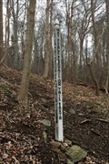
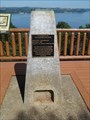 view gallery view galleryNW7.2 km |  Susquehannock JV4845 - Conestoga, PA Susquehannock JV4845 - Conestoga, PA
in U.S. Benchmarks Take a hike up the Turkey Hill Overlook Trail at the Turkey Hill Preserve in Conestoga PA and you will have not only a close up view of two wind turbines but also a gorgeous view of the Susquehanna River from a platform holding an NGS marker. posted by: Janila location: Pennsylvania date approved: 11/05/2018 last visited: never |
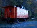 view gallery view galleryNW7.4 km |  Pennsylvania Railroad Caboose #23832 - Conestoga, PA Pennsylvania Railroad Caboose #23832 - Conestoga, PA
in Train Cabooses A cheerful, restored Pennsylvania Railroad caboose greets bikers and hikers as they begin their trip along the Enola Low Grade rail trail in Conestoga, PA. posted by: Janila location: Pennsylvania date approved: 11/13/2018 last visited: never |
 view gallery view galleryNW7.4 km |  Enola Low Grade "Tower" - Conestoga, PA Enola Low Grade "Tower" - Conestoga, PA
in Look-Out Towers The Enola Low Grade is a rail trail that runs along the scenic Susquehanna Railroad. posted by: Janila location: Pennsylvania date approved: 11/05/2018 last visited: never |
 view gallery view gallery E7.6 km E7.6 km
| Baumgardner's Mill Covered Bridge in U.S. National Register of Historic Places Baumgardner's Mill Covered Bridge is located on Covered Bridge Road, near Marticville, Lancaster County, Pennsylvania. posted by: deano1943 location: Pennsylvania date approved: 08/27/2006 last visited: 07/08/2018 |
 view gallery view galleryE7.7 km | Baumgardner's Mill Covered Bridge in Covered Bridges This bridge is located on Covered Bridge Road, Marticville, between Pequea and Martic Townships, Lancaster County, Pennsylvania. posted by: deano1943 location: Pennsylvania date approved: 05/14/2006 last visited: 07/08/2018 |
 view gallery view galleryNW7.7 km |  Turkey Hill Trail - Conestoga, PA Turkey Hill Trail - Conestoga, PA
in Hiking and walking trailheads Once the home of the Susquehannock Indians, the Turkey Hill Preserve now offers the Turkey Hill Overlook trail for hikers with a rewarding view if you reach the top. posted by: Janila location: Pennsylvania date approved: 11/14/2018 last visited: never |
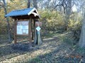
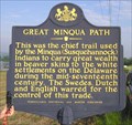 view gallery view galleryNW8.7 km | Great Minque Path in Pennsylvania Historical Markers This historical marker is located on River Road near Washington Borough, Lancaster County, Pennsylvania. posted by: deano1943 location: Pennsylvania date approved: 05/13/2006 last visited: 09/07/2015 |
 view gallery view galleryN9 km |  St. Paul's Lutheran Memorial Marker - Millersville, PA St. Paul's Lutheran Memorial Marker - Millersville, PA
in Churchyard Cemeteries No headstones. Grassy area with stone memorial and metal plate to those buried at St. Paul's Lutheran Church in Millersville, PA. posted by: BethKatzPA location: Pennsylvania date approved: 01/28/2015 last visited: never |
 view gallery view galleryNW9.2 km | Ebenezer Baptist Church and Churchyard, York County, Pennsylvania in Churchyard Cemeteries Ebenezer Baptist Church and Churchyard is along the Susquehanna River at Long Level, York County, Pennsylvania.
posted by: deano1943 location: Pennsylvania date approved: 03/24/2009 last visited: 06/25/2011 |
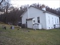 view gallery view galleryNW9.2 km |  Ebenezer Baptist Church Cemetery, York County, Pennsylvania Ebenezer Baptist Church Cemetery, York County, Pennsylvania
in Worldwide Cemeteries Ebenezer Baptist Church and Cemetery is along the Susquehanna River at Long Level, York County, Pennsylvania. posted by: deano1943 location: Pennsylvania date approved: 03/24/2009 last visited: 06/25/2011 |
|