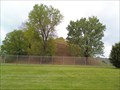
 view gallery view gallery E0 km E0 km
|   Grave Creek Mound Grave Creek Mound
in New World Ancient Evidence Grave Creek Mound Archaeology Complex. An ancient burial mound located in Moundsville, WV posted by:  wvhunter wvhunter location: West Virginia date approved: 08/28/2006 last visited: 08/20/2012 |
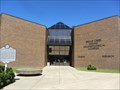 view gallery view gallery NE0.2 km NE0.2 km
|  Grave Creek Mound Archaeological Complex - Moundsville, WV Grave Creek Mound Archaeological Complex - Moundsville, WV
in Science Museums Located at the site of the famous Grave Creek Mound posted by:  uccacher uccacher location: West Virginia date approved: 08/19/2011 last visited: 03/31/2016 |
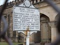
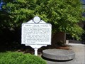 view gallery view galleryNE0.2 km |  Grave Creek Mound Grave Creek Mound
in West Virginia Historical Markers Outside the museum for the famous Mound in Moundsville, WV.
When we visited, the museum and grounds were closed for renovations! posted by: Algoma! location: West Virginia date approved: 10/01/2007 last visited: 03/31/2016 |
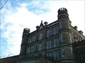 view gallery view gallery SE0.2 km SE0.2 km
|  West Virginia State Penitentiary West Virginia State Penitentiary
in Retired Prisons Classic fortress style prison (scary looking!)now used as a criminal justice training center. Tours are available as well! posted by: Algoma! location: West Virginia date approved: 10/07/2007 last visited: 08/20/2012 |
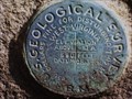 view gallery view gallery NW0.2 km NW0.2 km
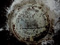
|  Marshall County Courthouse Benchmark Marshall County Courthouse Benchmark
in U.S. Benchmarks Geological Survey Marker in good condition on the base wall of the Marshall County Courthouse. posted by: Algoma! location: West Virginia date approved: 12/30/2007 last visited: 12/27/2008 |
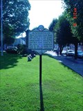 view gallery view galleryNW0.2 km | Moundsville in West Virginia Historical Markers Moundsville Historical Marker posted by: The Finding Irish 4 location: West Virginia date approved: 07/16/2008 last visited: 08/20/2012 |
 view gallery view galleryNW0.2 km | Capt. James Harrod in West Virginia Historical Markers Capt. James Harrod Historical Marker posted by: The Finding Irish 4 location: West Virginia date approved: 07/16/2008 last visited: 02/17/2014 |
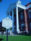
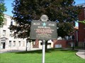 view gallery view galleryNW0.2 km |  Marshall County Courthouse, Moundsville, WV Marshall County Courthouse, Moundsville, WV
in Blue Star Memorial Highway Markers Found outside the courthouse in Moundsville, West Virginia. posted by: Algoma! location: West Virginia date approved: 12/28/2007 last visited: never |
 view gallery view gallery W0.5 km W0.5 km
| West Virginia Penitentiary in West Virginia Historical Markers A prison for men and women convicted of felonies posted by: two-bit Joe location: West Virginia date approved: 11/25/2007 last visited: 08/04/2012 |
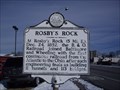 view gallery view gallery SW0.5 km SW0.5 km
| Rosby's Rock in West Virginia Historical Markers Near here the B & O Railroad joined the Baltimore and Wheeling railroad. posted by: Paintedwarrior location: West Virginia date approved: 02/19/2014 last visited: 03/01/2014 |
 view gallery view galleryNE0.8 km |  Moundsville WV 26041 Post Office Moundsville WV 26041 Post Office
in U.S. Post Offices Moundsville WV 26041 Post Office posted by: dukemartin location: West Virginia date approved: 02/18/2014 last visited: never |
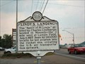 view gallery view galleryNW1 km | Lindy's Landing in West Virginia Historical Markers The "Spirit of St. Louis," piloted by Charles Lindbergh landed in Moundsville posted by: two-bit Joe location: West Virginia date approved: 11/25/2007 last visited: 02/17/2014 |
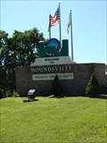 view gallery view gallery N1.8 km N1.8 km
|  Progress Through Unity - Moundsville, WV Progress Through Unity - Moundsville, WV
in Welcome Signs Welcome sign for Moundsvville, WV posted by: uccacher location: West Virginia date approved: 08/23/2011 last visited: never |
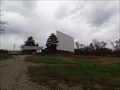 view gallery view galleryN2.3 km |  Glen Dale Drive-In Glen Dale Drive-In
in Closed Drive-In Theatres West Virginia drive-in that has been closed for almost a decade. posted by: Wallyum location: West Virginia date approved: 04/02/2021 last visited: never |
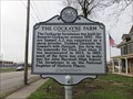 view gallery view galleryN3.1 km | The Cockayne Farm in West Virginia Historical Markers The large farm had the town Glen Dale named after it. The farm house is on the Nation Register of Historic Places. posted by: dukemartin location: West Virginia date approved: 04/01/2018 last visited: 04/01/2018 |
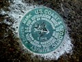 view gallery view gallerySW3.2 km |  CX4258(MROZ AZ MK) - Marshall County WV CX4258(MROZ AZ MK) - Marshall County WV
in Azimuth Benchmarks This is the azimuth mark for USC&GS triangulation station MROZ, in Marshall County. posted by: shorbird location: West Virginia date approved: 05/27/2017 last visited: never |
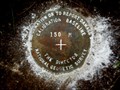 view gallery view gallery S3.9 km S3.9 km
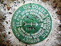
| MOUNDSVILLE CBL 150 - Marshall County WV in U.S. Benchmarks This is the 150-meter National Geodetic Survey calibration baseline disk at the Marshall County Airport. posted by: shorbird location: West Virginia date approved: 05/21/2017 last visited: never |
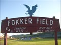 view gallery view galleryN4.2 km |  Fokker Field, Glen Dale, WV Fokker Field, Glen Dale, WV
in Airports Fokker Field is a small grassy field located in Glen Dale, WV. posted by: wvhunter location: West Virginia date approved: 09/22/2005 last visited: never |
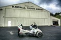 view gallery view galleryS4.2 km |  Marshall County Airport (West Virginia) Marshall County Airport (West Virginia)
in Wikipedia Entries Marshall County Airport (ICAO: KMPG, FAA LID: MPG, formerly 74D) is a public airport located in Moundsville. Situated in rugged mountain terrain, the airport site is a removed mountaintop with steep slopes to all sides. posted by: nomadwillie location: West Virginia date approved: 04/06/2023 last visited: never |
 view gallery view galleryS4.2 km | Marshall County Airport - Moundsville, WV in Airports Marshall County Airport (ICAO: KMPG, FAA LID: MPG, formerly 74D) is a public airport located in Moundsville. Situated in rugged mountain terrain, the airport site is a removed mountaintop with steep slopes to all sides. posted by: nomadwillie location: West Virginia date approved: 04/07/2023 last visited: never |
 view gallery view galleryN4.2 km | Harriet B. Jones in West Virginia Historical Markers Historical marker located along Wheeling Avenue in Glen Dale, WV. posted by: uccacher location: West Virginia date approved: 08/21/2011 last visited: 02/17/2014 |
 view gallery view galleryS4.3 km | MOUNDSVILLE CBL 100 - Marshall County WV in U.S. Benchmarks This is the 100-foot National Geodetic Survey tape calibration station disk at the Marshall County Airport. posted by: shorbird location: West Virginia date approved: 05/21/2017 last visited: never |
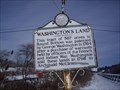 view gallery view gallerySW4.7 km | Washington's Land in West Virginia Historical Markers George Washington owned 587 acres here, sold it in 1798. posted by: Paintedwarrior location: West Virginia date approved: 02/19/2014 last visited: 03/01/2014 |
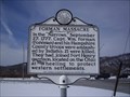 view gallery view galleryN6.9 km | Forman Massacre in West Virginia Historical Markers A sign telling about the ambush of Captain William Forman. posted by: Paintedwarrior location: West Virginia date approved: 02/19/2014 last visited: 03/01/2014 |
 view gallery view gallerySW7.9 km | CX5217(POWHATAN AZ MK) - Powhatan Point OH in Azimuth Benchmarks This is the azimuth mark for USC&GS triangulation station POWHATAN, in Powhatan Point, Belmont County. posted by: shorbird location: Ohio date approved: 10/23/2016 last visited: never |
|