 view gallery view gallery SW2.7 km SW2.7 km
|   Jack Weinstein-Wheeler, KS Jack Weinstein-Wheeler, KS
in Medal Of Honor Resting Places Korean War Medal of Honor Recipient for action at Kumson, Korea on October 19, 1951. He is buried in Wheeler Cemetery, Wheeler, KS in Row 5. posted by:  Don.Morfe Don.Morfe location: Kansas date approved: 02/21/2018 last visited: 12/17/2021 |
 view gallery view gallery W10 km W10 km
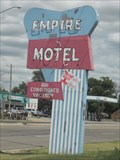
|  Empire Motel - St. Francis, KS Empire Motel - St. Francis, KS
in Neon Signs This vintage neon sign is for the Empire Motel in the small city of St. Francis, Kansas, USA. posted by:  Marine Biologist Marine Biologist location: Kansas date approved: 08/23/2011 last visited: never |
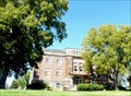
 view gallery view galleryW10 km |  Cheyenne County Courthouse, St Francis, Kansas Cheyenne County Courthouse, St Francis, Kansas
in Courthouses Cheyenne County's courthouse was built in 1924. posted by:  NevaP NevaP location: Kansas date approved: 10/03/2008 last visited: never |
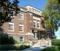
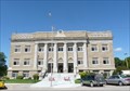 view gallery view galleryW10 km |  Cheyenne County Courthouse, St Francis ,Kansas Cheyenne County Courthouse, St Francis ,Kansas
in U.S. National Register of Historic Places This courthouse was built i 1924. posted by: NevaP location: Kansas date approved: 10/06/2008 last visited: never |
 view gallery view gallery NW11.4 km NW11.4 km
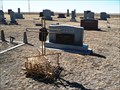
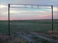
|  Grand Army of the Republic (G.A.R.) Cemetery - St. Francis, KS Grand Army of the Republic (G.A.R.) Cemetery - St. Francis, KS
in Worldwide Cemeteries This small cemetery is located about 5 miles north of the small town of St. Francis in the northwestern corner of Kansas. posted by: condor1 location: Kansas date approved: 11/16/2009 last visited: 10/26/2021 |
 view gallery view gallery E13.7 km E13.7 km
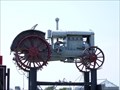
|  McCormick-Deering 15-30 Tractor - Road 29, Bird City, Kansas McCormick-Deering 15-30 Tractor - Road 29, Bird City, Kansas
in Old Tractors McCormick-Deering 15-30 Tractor located near the road 29, in Bird City, Kansas posted by: oiseau_ca location: Kansas date approved: 11/07/2015 last visited: never |
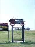 view gallery view galleryE13.7 km |  McCormick-Deering 15-30 Tractor - Road 29, Bird City, Kansas McCormick-Deering 15-30 Tractor - Road 29, Bird City, Kansas
in Elevated Everyday Objects McCormick-Deering 15-30 Tractor located near the road 29, in Bird City, Kansas posted by: oiseau_ca location: Kansas date approved: 12/21/2015 last visited: never |
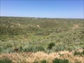 view gallery view gallery N25.9 km N25.9 km
|  Arikaree Breaks - Cheyenne County, KS Arikaree Breaks - Cheyenne County, KS
in Places of Geologic Significance The Arikaree Breaks are a rugged landscape of canyons that have formed in a type of windblown silt called loess. #628 posted by: TerraViators location: Kansas date approved: 07/27/2016 last visited: 05/01/2023 |
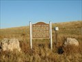 view gallery view gallery SE28.5 km SE28.5 km
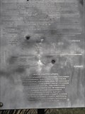
|  The Kidder Massacre The Kidder Massacre
in Kansas Historical Markers The location of an indian battle where the party of cavalry soldiers led by Lt. Kidder were killed. posted by: Kansas Stasher location: Kansas date approved: 10/17/2006 last visited: 01/24/2008 |
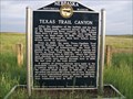 view gallery view galleryNW32.8 km |  Texas Trail Canyon Texas Trail Canyon
in Nebraska Historical Markers This marker is located along US-34 about 4 miles east of Haigler, Nebraska. There are several stone pillars near the marker which appear to mark or signify the many dead that are reference on the marker. One stone which appears to have had a plaque. posted by: condor1 location: Nebraska date approved: 07/20/2009 last visited: 07/05/2022 |
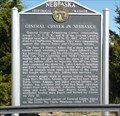 view gallery view galleryN33.2 km | General Custer in Nebraska in Nebraska Historical Markers Seven years before he met his fate at the Little Big Horn General Custer camped near here and had several encounters with the natives. posted by: NevaP location: Nebraska date approved: 10/03/2008 last visited: 09/04/2019 |
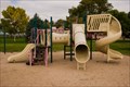 view gallery view galleryN34 km |  Ward Bond Memorial Park Playground - Benkelman, NE Ward Bond Memorial Park Playground - Benkelman, NE
in Public Playgrounds A quiet playground located in a park named for the actor Ward Bond in the town of his birthplace. posted by: IJAdventures location: Nebraska date approved: 10/18/2012 last visited: never |
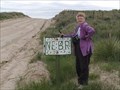
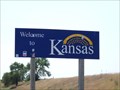 view gallery view galleryNW34.4 km |  Nebraska / Kansas Border - Highway 27, Kansas Nebraska / Kansas Border - Highway 27, Kansas
in Border Crossings a border crossing between the US states of Nebraska and Kansas located on highway 27 in Kansas, USA. posted by: oiseau_ca location: Kansas date approved: 09/20/2015 last visited: 04/28/2015 |
 view gallery view galleryN34.8 km | Dundy County Courthouse, Benkelman, Nebraska in Courthouses Dundy County's courthouse was built in 1921. posted by: NevaP location: Nebraska date approved: 10/08/2008 last visited: 09/29/2012 |
 view gallery view galleryN34.8 km | Dundy County Courthouse, Benkelman, NE in U.S. National Register of Historic Places Dundy County's courthouse was designed in American Movements style. posted by: NevaP location: Nebraska date approved: 10/06/2008 last visited: 09/29/2012 |
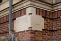 view gallery view galleryN34.8 km |  1921 - Dundy County Courthouse - Benkelman, NE 1921 - Dundy County Courthouse - Benkelman, NE
in Dated Buildings and Cornerstones The Dundy County Courthouse, built in 1921, was listed on the National Register of Historic Places in 1990. posted by: IJAdventures location: Nebraska date approved: 10/18/2012 last visited: never |
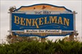 view gallery view galleryN35.9 km |  Benkelman: "Realize Our Potential" - Benkelman, NE Benkelman: "Realize Our Potential" - Benkelman, NE
in Welcome Signs This large welcome sign is hard to miss as you enter the town of Benkelman, Nebraska. posted by: IJAdventures location: Nebraska date approved: 10/19/2012 last visited: never |
 view gallery view galleryNW39.4 km | Nebraska-Kansas - backroad sign in Border Crossings Nebraska-Kansas border on a county road. posted by: NevaP location: Nebraska date approved: 08/16/2005 last visited: 05/21/2021 |
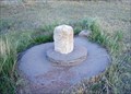 view gallery view galleryNW41.4 km |  Chaffees Corner - NW Corner Border of Kansas Chaffees Corner - NW Corner Border of Kansas
in U.S. Historic Survey Stones and Monuments This carved pillar of Limestone marks the north west corner of Kansas. Actually it marks a location 615 feet south of the actual plotted corner as replotted in 1993. posted by: condor1 location: Kansas date approved: 07/11/2009 last visited: 05/08/2021 |
 view gallery view galleryNW41.5 km |  Sixth Principle Meridian - Wray, CO Sixth Principle Meridian - Wray, CO
in Great Lines of Earth This marker commemorates the various surveys that were done in the 19th century near the corner point of of Kansas, Nebraska, and Colorado. Some of those surveys related to the 6th Principle Meridian which marks the border between Kansas & Nebraska. posted by: onfire4jesus location: Colorado date approved: 04/15/2014 last visited: 10/26/2021 |
 view gallery view galleryNW41.5 km |  3 Corners Boundry Marker - KS / CO / NE 3 Corners Boundry Marker - KS / CO / NE
in U.S. Benchmarks The 3-Corners Benchmark is located at the junction of the borders of Colorado, Kansas and Nebraska. posted by: condor1 location: Kansas date approved: 07/12/2009 last visited: 10/26/2021 |
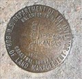 view gallery view galleryNW41.5 km |  3 Corners Boundary Marker - KS / CO / NE 3 Corners Boundary Marker - KS / CO / NE
in Tripoints and Multipoints The Tri-Point is identified by the 3-Corners Benchmark and is located at the junction of the borders of Colorado, Kansas and Nebraska. posted by: condor1 location: Colorado date approved: 04/11/2012 last visited: 10/26/2021 |
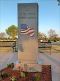 view gallery view gallery S43.9 km S43.9 km
|  Goodland Veterans Memorial - Goodland, KS Goodland Veterans Memorial - Goodland, KS
in Non-Specific Veteran Memorials This veterans memorial, set in a field of veteran graves, is at Goodland Cemetery in Goodland, Kansas. posted by: The Snowdog location: Kansas date approved: 05/16/2021 last visited: never |
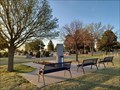 view gallery view galleryS43.9 km |  Cemetery Benches - Goodland, KS Cemetery Benches - Goodland, KS
in Eagle Scout Project Sites The benches at this veterans memorial were set as an Eagle Scout Project - in Goodland Cemetery, Goodland, Kansas. posted by: The Snowdog location: Kansas date approved: 05/14/2021 last visited: never |
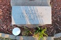 view gallery view galleryS43.9 km |  Enoch Smith - Goodland, Kansas Enoch Smith - Goodland, Kansas
in Citizen Memorials The flagpole at the veterans memorial in Goodland Cemetery was set in memory of Enoch Smith - in Goodland, Kansas. posted by: The Snowdog location: Kansas date approved: 05/14/2021 last visited: never |
|