 view gallery view gallery S3.7 km S3.7 km
|   Eisenhower-Johnson Memorial Tunnel and Related Highway - Colorado Eisenhower-Johnson Memorial Tunnel and Related Highway - Colorado
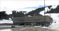
in Engineering Landmarks Eisenhower-Johnson Tunnel is both the highest and longest auto tunnel on Colorado's I-70 corridor. The the ASCE bestowed on CDOT the 1993 Outstanding Civil Engineering Achievement Award for this section of highway. posted by:  Outspoken1 Outspoken1 location: Colorado date approved: 08/05/2012 last visited: 02/04/2023 |
 view gallery view galleryS3.7 km |  Eisenhower Memorial Tunnel - Colorado Eisenhower Memorial Tunnel - Colorado
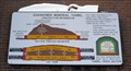
in Colorado Historical Markers Eisenhower Memorial Tunnels on I-70 in Colorado Central Mountain corridor posted by: Outspoken1 location: Colorado date approved: 02/02/2008 last visited: 11/08/2019 |
 view gallery view galleryS3.7 km |  HIGHEST & LONGEST & FIRST - Eisenhower-Johnson Memorial Tunnels - Colorado HIGHEST & LONGEST & FIRST - Eisenhower-Johnson Memorial Tunnels - Colorado
in Superlatives Simple known as "the Tunnel' in Colorado, these feats of engineering are critical to transportation in the United States posted by: Outspoken1 location: Colorado date approved: 08/07/2010 last visited: 07/18/2014 |
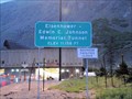 view gallery view galleryS3.9 km |  Edwin C. Johnson Memorial Tunnel - Summit County, CO USA - 11,158' Edwin C. Johnson Memorial Tunnel - Summit County, CO USA - 11,158'
in Elevation Signs Elevation sign on westbound I-70 at 'The Tunnel' posted by: Outspoken1 location: Colorado date approved: 08/07/2010 last visited: 06/22/2018 |
 view gallery view gallery SE4 km SE4 km
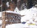
|  Loveland Basin Ski Area - Colorado Loveland Basin Ski Area - Colorado
in Winter Sports Locations Loveland Pass and Loveland Basin are two seperate sections of Loveland Ski Resort located in beautiful Georgetown, CO.
posted by:  ganurse ganurse location: Colorado date approved: 01/27/2008 last visited: 03/02/2008 |
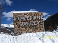 view gallery view gallerySE4.2 km | Loveland Valley Ski Area - Colorado in Winter Sports Locations Loveland Pass and Loveland Basin are two seperate sections of Loveland Ski Resort located in beautiful Georgetown, CO. posted by: ganurse location: Colorado date approved: 01/27/2008 last visited: 03/02/2008 |
 view gallery view gallery E4.3 km E4.3 km
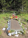
|  1970 Wichita State Football Team Crash - Summit County, CO 1970 Wichita State Football Team Crash - Summit County, CO
in Plane Crash Sites Crash in 1970 killed 31 of the 40 on board of the Wichita State University Football Team posted by: Outspoken1 location: Colorado date approved: 07/11/2010 last visited: 10/06/2014 |
 view gallery view galleryE4.3 km | 1970 Wichita State Football Team Crash - Summit County, CO in Colorado Historical Markers Crash in 1970 killed 31 of the 40 on board of the Wichita State University Football Team posted by: Outspoken1 location: Colorado date approved: 07/11/2010 last visited: 10/06/2014 |
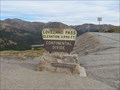 view gallery view gallerySE6.3 km |  Loveland Pass Loveland Pass
in Wikipedia Entries Loveland Pass is a mountain pass on the continental divide in the Rocky Mountains in Colorado. The elevation of the pass is 11,990 feet above sea level. posted by: adenium location: Colorado date approved: 09/16/2010 last visited: 07/06/2015 |
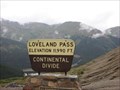 view gallery view gallerySE6.3 km | Loveland Pass, Colorado in Elevation Signs Loveland Pass, just east of the Loveland ski area posted by: ronjean location: Colorado date approved: 09/07/2008 last visited: 07/06/2015 |
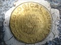
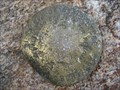 view gallery view gallerySE6.4 km |  U.S. Dept. of Agriculture Forest Service AS P 551 1939 U.S. Dept. of Agriculture Forest Service AS P 551 1939
in U.S. Benchmarks Forest Service mark on summit of Mt. Sniktau posted by: jkselby location: Colorado date approved: 11/25/2010 last visited: 08/13/2014 |
 view gallery view gallerySE12.2 km |  Grays Peak Grays Peak
in Mountain Summits One of the easier Colorado 14ers. posted by: t-xman location: Colorado date approved: 09/10/2005 last visited: 08/19/2010 |
 view gallery view gallery NW12.4 km NW12.4 km
|  Williams Fork Boardwalk - Grand County, CO Williams Fork Boardwalk - Grand County, CO
in Non-Coastal Boardwalks Abandoned boardwalk that connected Sugarloaf Campground to the South Fork Trail. posted by: valhikes location: Colorado date approved: 01/29/2024 last visited: 08/08/2022 |
 view gallery view gallery NE14.3 km NE14.3 km
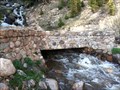
|  Hoop Creek Stone Bridge on Berthoud Pass US 40 Hoop Creek Stone Bridge on Berthoud Pass US 40
in Stone Bridges Decommissioned stoned bridge built in 1921 with view of Hoop Creek Waterfall. posted by: GreencoreOutfitters location: Colorado date approved: 06/06/2015 last visited: 07/15/2017 |
  SW14.6 km SW14.6 km
|  Nozawa Sushi, Dillon, Colorado Nozawa Sushi, Dillon, Colorado
in Sushi Restaurants Best sushi in the region, great teppanyaki grill, and killer cocktails. posted by: djohnsons123 location: Colorado date approved: 10/19/2010 last visited: 09/07/2015 |
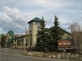 view gallery view gallerySW15.1 km |  Dillon Dam Brewery Dillon Dam Brewery
in Brewpubs This large brewpub/restaurant is located in a popular Colorado mountain tourist area. posted by:  NevaP NevaP location: Colorado date approved: 06/10/2009 last visited: 09/07/2015 |
 view gallery view gallerySE15.1 km | US Geological Survey benchmark COLO KII 1924 in U.S. Benchmarks USGS benchmark on Argentine Pass posted by: jkselby location: Colorado date approved: 08/13/2009 last visited: never |
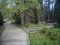
 view gallery view gallerySW15.6 km |  White River National Forest: Dillon Ranger Station - Dillon, CO White River National Forest: Dillon Ranger Station - Dillon, CO
in Ranger Stations Nestled in the heart of the Rocky Mountains, the 2.3 million acre White River National Forest is the top recreation Forest in the nation. Home to world-renowned ski resorts and the birthplace of Wilderness Areas. posted by: CerealBoxMonsters location: Colorado date approved: 07/08/2012 last visited: never |
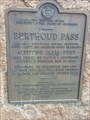 view gallery view galleryNE15.8 km | Berthoud Pass - Berthoud Pass, CO in Colorado Historical Markers This historical marker is located at the summit of Berthoud Pass at an elevation of 11,307 ft. posted by: mr.volkswagen location: Colorado date approved: 08/19/2017 last visited: 08/17/2017 |
 view gallery view galleryNE15.8 km | Berthoud Pass, CO (11,307 ft) in Elevation Signs Located on the Continental Divide of Highway 40. posted by: mr.volkswagen location: Colorado date approved: 08/21/2017 last visited: 08/21/2017 |
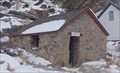 view gallery view galleryE16.6 km |  Silver Plume Jail - Silver Plume, CO Silver Plume Jail - Silver Plume, CO
in Retired Prisons The Silver Plume Jail was in service from 1875 to 1915 - in Silver Plume, Colorado. posted by: The Snowdog location: Colorado date approved: 12/30/2022 last visited: never |
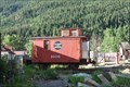 view gallery view galleryE16.7 km |  Colorado & Southern 1006 Colorado & Southern 1006
in Train Cabooses Colorado & Southern 1006 is on permanent display in downtown Silver Plume, Colorado. posted by: brwhiz location: Colorado date approved: 12/04/2012 last visited: 11/08/2019 |
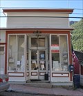 view gallery view galleryE16.7 km |  Silver Plume, Colorado 80476 Silver Plume, Colorado 80476
in U.S. Post Offices This Post Office is located at 850 Main Street in Silver Plume, Colorado. posted by: brwhiz location: Colorado date approved: 10/24/2011 last visited: 11/08/2019 |
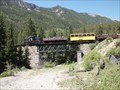 view gallery view galleryE16.9 km |  Georgetown Loop; Silver Plume Station - Silver Plume, CO Georgetown Loop; Silver Plume Station - Silver Plume, CO
in Scenic Railroads Silver Plume is the western terminus for this historic railroad. posted by: cldisme location: Colorado date approved: 07/03/2010 last visited: 09/27/2019 |
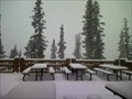 view gallery view galleryS16.9 km |  The Outpost Lodge The Outpost Lodge
in Ski Lodges The Outpost Lodge at Keystone posted by: mappicus location: Colorado date approved: 12/30/2006 last visited: 06/07/2006 |
|