 view gallery view gallery N0.6 km N0.6 km
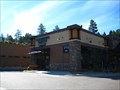
|   Conifer Town Center - Conifer, CO Conifer Town Center - Conifer, CO
in Starbucks Stores The Conifer Town Center Conifer Starbucks sits at the southern end of the center and offers drip brewed coffee, espresso and other drinks and snacks and is also a free WiFi hotspot. posted by:  CerealBoxMonsters CerealBoxMonsters location: Colorado date approved: 08/22/2010 last visited: 07/16/2011 |
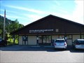 view gallery view galleryN2.7 km |  Conifer, CO - 80433 Conifer, CO - 80433
in U.S. Post Offices This Post Office serves the community of Conifer, Aspen Park and the surrounding community. posted by: CerealBoxMonsters location: Colorado date approved: 08/21/2010 last visited: 07/16/2011 |
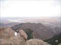
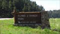 view gallery view gallery NW3.1 km NW3.1 km
|  Flying J Ranch Open Space - Conifer, CO Flying J Ranch Open Space - Conifer, CO
in Hiking and walking trailheads The Ranch, complete with historic runway built by former airline pilot Captain John Schoonhoven, lends this park a fitting name. Healthy meadows, forests, wetlands and stream provide habitat for songbirds, raptors and wintering elk. posted by: CerealBoxMonsters location: Colorado date approved: 07/10/2012 last visited: never |
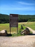 view gallery view gallery NE4 km NE4 km
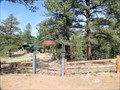
| Meyers Ranch Open Space Park - Aspen Park, CO in Hiking and walking trailheads Trails that can be accessed from this trailhead will lead hikers through grassy meadows, pine forests, aspen parks, and high rocky mountain summits. posted by: CerealBoxMonsters location: Colorado date approved: 08/21/2010 last visited: 06/29/2014 |
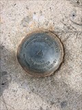 view gallery view gallery SW10 km SW10 km
|  Benchmark AA7133 - Pine Junction, CO Benchmark AA7133 - Pine Junction, CO
in U.S. Benchmarks Horizontal control disk A17733 at the Pine Junction, CO helipad. #13220 posted by:  TerraViators TerraViators location: Colorado date approved: 09/23/2016 last visited: 07/03/2016 |
 view gallery view gallerySW10 km | Pine, CO - 80470 in U.S. Post Offices This Post Office serves the town of Pine and the surrounding communities. posted by: CerealBoxMonsters location: Colorado date approved: 08/21/2010 last visited: never |
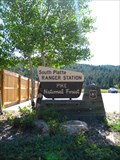 view gallery view galleryNE10.5 km |  Pike National Forest: South Platte Ranger Station - Morrison, CO Pike National Forest: South Platte Ranger Station - Morrison, CO
in Ranger Stations Pike National Forest sits primarily along the front range of Colorado's Rocky Mountains. It encompasses 1,106,604 acres, including Pikes Peak, parts of Mt. Evans and Lost Creek Wilderness Areas, and its largest drainage is the South Platte River. posted by: CerealBoxMonsters location: Colorado date approved: 08/22/2010 last visited: 08/03/2011 |
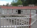
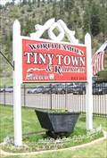 view gallery view galleryNE11.6 km |  Tiny Town, Morrison, CO Tiny Town, Morrison, CO
in Roadside Attractions Many small buildings for children to peek into. posted by: ronjean location: Colorado date approved: 06/10/2013 last visited: 07/16/2021 |
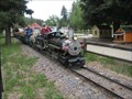 view gallery view galleryNE11.6 km |  Tiny Town Tiny Town
in Miniature Railroads This miniature railroad is located in Tiny Town, CO. posted by: Team Min Dawg location: Colorado date approved: 07/10/2008 last visited: 07/16/2021 |
 view gallery view galleryNE11.6 km | Tiny Town Roundhouse in Railway Roundhouses This Roundhouse is located in Tiny Town, CO. It is not a full size roundhouse, but neither is anything else in Tiny Town!
posted by: Team Min Dawg location: Colorado date approved: 07/11/2008 last visited: 07/16/2021 |
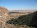
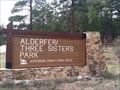 view gallery view galleryN11.9 km | Alderfer/Three Sisters Open Space Park - Evergreen, CO in Hiking and walking trailheads Alderfer/Three Sisters Park boasts 770 acres of open space and over 10 miles of trails. The four rock formations, called the Three Sisters and The Brother, have been landmarks providing spectacular views of the Bear Creek Basin for over a century. posted by: CerealBoxMonsters location: Colorado date approved: 07/08/2012 last visited: 08/13/2020 |
 view gallery view gallery E12.1 km E12.1 km
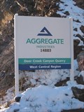
|  Deer Creek Canyon Quarry Deer Creek Canyon Quarry
in Active Quarries Natutal aggregates are quarried here. posted by: Team Min Dawg location: Colorado date approved: 11/15/2005 last visited: never |
 view gallery view gallerySW12.2 km |  Smokey Bear - near Pine Gulch, Colorado Smokey Bear - near Pine Gulch, Colorado
in Smokey Bear Sign Sightings This Smokey Bear is visible from Hwy 285, the Ralph Carr Memorial Highway posted by: Outspoken1 location: Colorado date approved: 06/24/2011 last visited: 07/29/2011 |
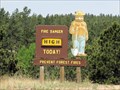
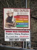 view gallery view galleryNE12.4 km | Indian Hills Smokey Bear - Indian Hills, CO in Smokey Bear Sign Sightings This is a variation on the usual sign in that this life-sized Smokey 'points' to the fire danger level. This sign is found at the main turn off into Indian Hills from the highway 285. posted by: Outspoken1 location: Colorado date approved: 05/21/2015 last visited: 07/15/2017 |
 view gallery view galleryE12.7 km |  Jack Klugman Fans Blog Jack Klugman Fans Blog
in Bloggers A blog for fans to talk about, and ask Jack Klugman questions. posted by: Team Min Dawg location: Colorado date approved: 10/31/2005 last visited: 12/12/2022 |
 view gallery view galleryE12.7 km |  Deer Creek Canyon - Littleton, CO( Deer Creek Canyon - Littleton, CO(
in Bookcrossing Zones This Bookcrossing Zone is at a geocache in Deer Creek Canyon Park near Littleton, CO. It is a bit of a walk with significant elevation gain. It is worth the walk for the AWESOME views, and it is quieter than a library! It is a great place to sit and read a book. posted by: Team Min Dawg location: Colorado date approved: 09/30/2005 last visited: 05/29/2014 |
 view gallery view gallery S12.7 km S12.7 km
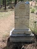
|  Little Chapel in the Hills Cemetery - Buffalo Creek, CO Little Chapel in the Hills Cemetery - Buffalo Creek, CO
in NRHP Historic Districts - Contributing Buildings This cemetery was the final home for the many young who died in the 1882-84 typhoid epidemic. posted by: Outspoken1 location: Colorado date approved: 06/19/2013 last visited: never |
 view gallery view galleryS12.7 km |  Little Chapel in the Hills Cemetery - Buffalo Creek, CO Little Chapel in the Hills Cemetery - Buffalo Creek, CO
in Churchyard Cemeteries This cemetery was the final home for the many young who died in the 1882-84 typhoid epidemic. posted by: Outspoken1 location: Colorado date approved: 05/18/2015 last visited: never |
 view gallery view galleryS13 km | Crystal Lake - Pine, CO in NRHP Historic Districts - Contributing Buildings This lake provided both ice for bustling Denver and a beautiful vacation area for visitors since 1872 - before Colorado became a state! posted by: Outspoken1 location: Colorado date approved: 06/19/2013 last visited: 07/26/2014 |
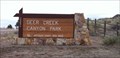
 view gallery view galleryE13.4 km |  Deer Creek Canyon Park Deer Creek Canyon Park
in Mountain Bike Trailheads A fun steep ride with some technical spots and great views at the top and along the way. posted by: Team Min Dawg location: Colorado date approved: 09/24/2005 last visited: 02/20/2016 |
 view gallery view galleryE13.4 km | Deer Creek Canyon Open Space Park - Ken Caryl, CO in Hiking and walking trailheads Multi-use and hiker only trails provide many options for park visitors. posted by: CerealBoxMonsters location: Colorado date approved: 05/12/2012 last visited: 02/20/2016 |
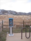 view gallery view galleryE13.4 km |  Deer Creek Canyon Park Payphone Deer Creek Canyon Park Payphone
in Payphones This payphone is located at Deer Creek Canyon Park...A Jefferson County park. posted by: Team Min Dawg location: Colorado date approved: 11/20/2005 last visited: 07/07/2010 |
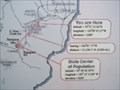
 view gallery view galleryE13.4 km | 2000 Center of Population State of Colorado Benchmark in U.S. Benchmarks This benchmark marks the Center of Population for the State of Colorado and its 4,301,261 residents based on the 2000 census data. posted by: Team Min Dawg location: Colorado date approved: 12/25/2006 last visited: 02/20/2016 |
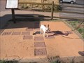 view gallery view galleryE13.4 km |  Deer Creek Canyon Compass Rose Deer Creek Canyon Compass Rose
in Compass Roses This compass rose is at the trail head at Deer Creek Canyon Park. From this spot, you can bike, hike or ride your horse on several beautiful trails all with awesome views! Another interesting feature of this compass rose is that it is the center of Colorado population, Census 2000. posted by: Team Min Dawg location: Colorado date approved: 10/02/2005 last visited: 02/20/2016 |
 view gallery view galleryE14 km |  Goat Mountain-near Littleton, Colorado Goat Mountain-near Littleton, Colorado
in Mountain Summits Goat Mountain is in the foothills near Denver, Colorado. posted by: Team Min Dawg location: Colorado date approved: 04/02/2006 last visited: 12/19/2010 |
|