 view gallery view gallery NW0.3 km NW0.3 km
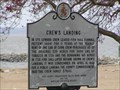
|   Crew's Landing Crew's Landing
in Maryland Historical Markers Crew’s Landing
posted by:  DaisyChain DaisyChain location: Maryland date approved: 04/04/2006 last visited: 05/31/2020 |
 view gallery view gallery S4.7 km S4.7 km
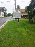
| Maryland's First Women Voters in Maryland Historical Markers Maryland's First Women Voters posted by: pseudoprime location: Maryland date approved: 06/24/2013 last visited: 04/20/2019 |
 view gallery view gallery NE5 km NE5 km
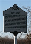
| Hazelmore in Maryland Historical Markers Land originally granted to Phillip Calvert... posted by: ODragon location: Maryland date approved: 01/03/2009 last visited: 04/02/2012 |
 view gallery view gallery E6.8 km E6.8 km
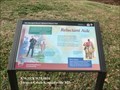
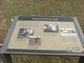
|  Reluctant Aide Star-Spangled Banner National Historical Trail - Kennedyville, MD Reluctant Aide Star-Spangled Banner National Historical Trail - Kennedyville, MD
in War of 1812 On May 6, 1813, the British landed barges at Turner’s Creek—a village of about 60 people and an active port for grains and flour. posted by:  Don.Morfe Don.Morfe location: Maryland date approved: 02/29/2020 last visited: 11/02/2021 |
 view gallery view galleryE6.8 km |  Reluctant Aide Star-Spangled Banner National Historical Trail - Kennedyville, MD Reluctant Aide Star-Spangled Banner National Historical Trail - Kennedyville, MD
in Signs of History On May 6, 1813, the British landed barges at Turner’s Creek—a village of about 60 people and an active port for grains and flour. posted by: Don.Morfe location: Maryland date approved: 08/30/2022 last visited: 08/30/2022 |
 view gallery view galleryE6.8 km | Waterfront Hub for Trade - Kennedyville, MD in Signs of History The "Settlement at Turner's Creek" was developed by Donaldson Yeats before the Revolutionary War. It was a hub for trade. posted by: Don.Morfe location: Maryland date approved: 02/20/2020 last visited: 09/25/2021 |
 view gallery view gallery SE8.9 km SE8.9 km
|  Kennedyville United Methodist Church - Kennedyville, MD Kennedyville United Methodist Church - Kennedyville, MD
in Methodist Churches A methodist church in Kennedyville, Maryland. posted by: bluesnote location: Maryland date approved: 01/16/2022 last visited: never |
 view gallery view gallerySE8.9 km |  1900 - Kennedyville United Methodist Church - Kennedyville, MD 1900 - Kennedyville United Methodist Church - Kennedyville, MD
in Dated Buildings and Cornerstones A methodist church in Kennedyville, Maryland. posted by: bluesnote location: Maryland date approved: 01/16/2022 last visited: never |
 view gallery view gallerySE8.9 km |  Kennedyville United Methodist Church - Kennedyville, MD Kennedyville United Methodist Church - Kennedyville, MD
in Bell Towers A methodist church in Kennedyville, Maryland. posted by: bluesnote location: Maryland date approved: 01/16/2022 last visited: never |
 view gallery view gallerySE8.9 km |  Kennedyville United Methodist Church - Kennedyville, MD Kennedyville United Methodist Church - Kennedyville, MD
in This Old Church A methodist church in Kennedyville, Maryland. posted by: bluesnote location: Maryland date approved: 01/16/2022 last visited: never |
 view gallery view galleryS9 km |  Philip Reed - Warton MD Philip Reed - Warton MD
in Grave of a Famous Person Buried in Christ Church I.U. Churchyard Cemetery is General Philip Reed, A Soldier of the Revolution and of the War of 1812. Hero of Caulk's Field. posted by: Don.Morfe location: Maryland date approved: 09/06/2022 last visited: 09/06/2022 |
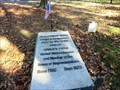
 view gallery view galleryS9 km |  Christ Church I.U. Churchyard Cemetery - Worton MD Christ Church I.U. Churchyard Cemetery - Worton MD
in Churchyard Cemeteries Buried in this Churchyard Cemetery is General Philip Reed, A Soldier of the Revolution and of the War of 1812. Hero of Caulk's Field. posted by: Don.Morfe location: Maryland date approved: 01/03/2021 last visited: 10/30/2021 |
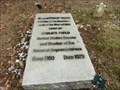
 view gallery view galleryS9 km |  General Philip Reed - Worton MD General Philip Reed - Worton MD
in American Revolutionary War Veteran Graves General Philp Reed is buried in Christ Church I.U. Churchyard Cemetery. posted by: Don.Morfe location: Maryland date approved: 01/09/2021 last visited: 10/19/2021 |
 view gallery view galleryS9 km |  Christ Church I.U. Churchyard Cemetery - Worton MD Christ Church I.U. Churchyard Cemetery - Worton MD
in Worldwide Cemeteries Buried in this Churchyard Cemetery is General Philip Reed, A Soldier of the Revolution and of the War of 1812. Hero of Caulk's Field. posted by: Don.Morfe location: Maryland date approved: 09/06/2022 last visited: 09/06/2022 |
 view gallery view galleryS9 km |  Taking Command - Worton MD Taking Command - Worton MD
in Battlefields Marker is on the grounds of Christ Church I.U. and Cemetery, Lambs Meadow Road, Worton, MD USA 21678 posted by: Don.Morfe location: Maryland date approved: 09/19/2023 last visited: 09/19/2023 |
 view gallery view galleryS9 km | Taking Command Star-Spangled Banner National Historic Trail - Worton MD in War of 1812 Lieutenant Colonel Philip Reed, buried here in 1829, excelled among Maryland militia officers. Reed countered several of the British hit-and-run raids along the Eastern Shore. posted by: Don.Morfe location: Maryland date approved: 03/24/2020 last visited: 11/02/2021 |
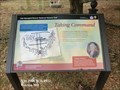 view gallery view galleryS9 km | Taking Command Star-Spangled Banner National Historic Trail - Worton MD in Signs of History Lieutenant Colonel Philip Reed, buried here in 1829, excelled among Maryland militia officers. Reed countered several of the British hit-and-run raids along the Eastern Shore. posted by: Don.Morfe location: Maryland date approved: 09/06/2022 last visited: 09/06/2022 |
 view gallery view galleryS9 km |  Christ Church IU - Worton, MD Christ Church IU - Worton, MD
in Anglican and Episcopal Churches A small congregation just meeting in an 18th century sanctuary. posted by: vhasler location: Maryland date approved: 03/21/2012 last visited: 09/06/2022 |
 view gallery view galleryS9 km | Christ Church IU - Worton, MD in This Old Church Christ Church IU at Worton Parish is an unobtrusively elegant mid-19th century brick sanctuary,(1850) and it is on the National Register of Historic Places as is its 18th century sexton’s house. posted by: Don.Morfe location: Maryland date approved: 02/15/2023 last visited: never |
 view gallery view galleryS9 km |  Christ Church, Graveyard and Sexton's House - Worton, MD Christ Church, Graveyard and Sexton's House - Worton, MD
in U.S. National Register of Historic Places Small brick Gothic Revival church built in 1765. posted by: vhasler location: Maryland date approved: 03/20/2012 last visited: 09/06/2022 |
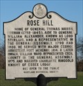 view gallery view galleryE9.7 km | Rose Hill in Maryland Historical Markers Home of General... posted by: ODragon location: Maryland date approved: 01/03/2009 last visited: never |
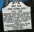 view gallery view gallerySE9.7 km | Brig. Gen. John Cadwalader in Maryland Historical Markers Commander Penna Troops. Served at... posted by: ODragon location: Maryland date approved: 01/03/2009 last visited: 07/19/2020 |
 view gallery view galleryNE10.1 km |  Turkey Point Lighthouse Turkey Point Lighthouse
in Coastal Lighthouses Turkey Point Lighthouse is located in the Elk Neck State Park. It was authorized by Congress in 1831 and was built in 1833 with a tower and keeper’s quarters by John Donohoo. posted by: chstress53 location: Maryland date approved: 10/06/2005 last visited: 11/06/2021 |
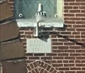
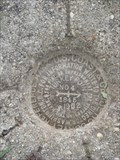 view gallery view galleryNE10.1 km |  TURKEY POINT RM 4 - Cecil County, MD TURKEY POINT RM 4 - Cecil County, MD
in U.S. Benchmarks Reference Mark for the now missing TURKEY POINT RESET (JV4849) located at the S end of Elk Neck State Park & overlooking the Chesapeake Bay. posted by: Ernmark location: Maryland date approved: 11/26/2014 last visited: 02/15/2019 |
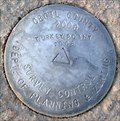 view gallery view galleryNE10.1 km | Turkey Point 2008, Cecil County, MD in U.S. Benchmarks Survey Control Marker posted by: polecat42 location: Maryland date approved: 01/20/2013 last visited: 02/15/2019 |
|