 view gallery view gallery W0.8 km W0.8 km
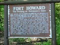
|   Fort Howard The Bulldog at Baltimore's Gate Marker-Fort Howard, MD Fort Howard The Bulldog at Baltimore's Gate Marker-Fort Howard, MD
in Signs of History Fort Howard had its beginning when the U. S. Government began to purchase land for the post in 1896. posted by:  Don.Morfe Don.Morfe location: Maryland date approved: 10/07/2019 last visited: 09/28/2021 |
 view gallery view gallery SW1 km SW1 km
|  Fort Howard Park, Blackberries, MD Fort Howard Park, Blackberries, MD
in Berry Picking A nice patch of blueberries located on top of an old military installation. posted by:  ODragon ODragon location: Maryland date approved: 07/16/2008 last visited: 04/26/2014 |
 view gallery view gallery NE1 km NE1 km
| The Rebirth of a Maryland Historical Treasure - Sparrows Point, MD in Signs of History Originally built in 1906 by the United Railways and Electric Company on this site, stood the once grand Bay Shore Park Restaurant. posted by: Don.Morfe location: Maryland date approved: 01/19/2020 last visited: 09/25/2021 |
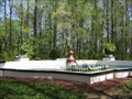 view gallery view galleryNE1 km |  North Point State Park North Point State Park
in Fountains This fountain was built in the early 1900's as part of the Bayshore Amusment Park. posted by: stratus location: Maryland date approved: 04/20/2006 last visited: 04/26/2014 |
 view gallery view galleryNE1.1 km | Dreaded Alarm Star-Spangled Banner National Historic Trail - Sparrows Point MD in Signs of History The cupola atop the Ridgely house, c. 1767 farmhouse located near here, served as a lookout station in 1813 and 1814, operated by Major Josiah Green. posted by: Don.Morfe location: Maryland date approved: 09/01/2022 last visited: 01/16/2023 |
 view gallery view galleryNE1.1 km |  Dreaded Alarm Star-Spangled Banner National Historic Trail - Sparrows Point MD Dreaded Alarm Star-Spangled Banner National Historic Trail - Sparrows Point MD
in War of 1812 The cupola atop the Ridgely house, c. 1767 farmhouse located near here, served as a lookout station in 1813 and 1814, operated by Major Josiah Green. posted by: Don.Morfe location: Maryland date approved: 03/18/2020 last visited: 11/02/2021 |
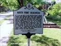 view gallery view galleryW1.1 km |  North Point Beachhead-Fort Howard, MD North Point Beachhead-Fort Howard, MD
in Maryland Historical Markers North Point Beachhead-At 3 a.m. on September 12, 1814, British began landing troops and supplies here from ships anchored in Old Road Bay. posted by: Don.Morfe location: Maryland date approved: 10/08/2019 last visited: 09/28/2021 |
 view gallery view galleryNE1.1 km | Hard Travel Captain John Smith Chesapeake National Historic Trail - Sparrows Point, MD in Signs of History John Smith and his crew visited this area in June 1608. After passing several shallow creeks, they entered the deep waters of the Patapsco River with hopes of finding exportable metals and a passage to the Pacific Ocean. posted by: Don.Morfe location: Maryland date approved: 01/19/2020 last visited: 09/25/2021 |
 view gallery view galleryNE1.1 km | John Smith Explores the Chesapeake Captain John Smith Chesapeake National Historical Trail - Sparrows Point, MD in Signs of History Captain John Smith explored the Chesapeake Bay in the early 1600s seeking precious metals and a passage to Asia. He traveled the James, Chickahominy, and York rivers in 1607, and led two major expeditions from Jamestown in 1608. posted by: Don.Morfe location: Maryland date approved: 01/19/2020 last visited: 09/25/2021 |
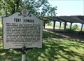 view gallery view galleryW1.3 km | Fort Howard-Fort Howard, MD in Maryland Historical Markers Fort Howard was built here in 1896 to defend Baltimore from possible naval attack. Named for Col. John Eager Howard, Revolutionary hero. posted by: Don.Morfe location: Maryland date approved: 10/08/2019 last visited: 09/28/2021 |
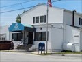
 view gallery view gallery NW1.3 km NW1.3 km
|  Fort Howard, Maryland 21052 Fort Howard, Maryland 21052
in U.S. Post Offices This a small post office located on 9200 Fort Howard Ave, Fort Howard MD. 21052 posted by: Don.Morfe location: Maryland date approved: 07/20/2021 last visited: 08/28/2021 |
 view gallery view galleryNW1.3 km |  Fort Howard, Maryland Fort Howard, Maryland
in Wikipedia Entries Fort Howard is an unincorporated community and census-designated place in Baltimore County. The GPS Coordinates are for the Fort Howard U.S. Post Office located at 9200 Fort Howard Ave, Fort Howard MD. 21052. posted by: Don.Morfe location: Maryland date approved: 12/02/2023 last visited: 07/15/2020 |
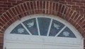 view gallery view galleryNW1.3 km |  Stained Glass Window above the front door - Fort Howard Community Church - Fort Howard MD Stained Glass Window above the front door - Fort Howard Community Church - Fort Howard MD
in Stained Glass Windows The stained Glass Window above the front door of the church. Fort Howard Community Church is a Gospel-Centered Ministry in Fort Howard, Maryland, located on North Point Peninsula in Baltimore County. posted by: Don.Morfe location: Maryland date approved: 07/20/2021 last visited: 08/28/2021 |
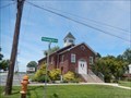 view gallery view galleryNW1.3 km |  Fort Howard Community Church - Fort Howard MD Fort Howard Community Church - Fort Howard MD
in Baptist Churches Fort Howard Community Church is a Gospel-Centered Ministry in Fort Howard, Maryland, located on North Point Peninsula in Baltimore County. We partner with the SBC and affirm The Baptist Faith and Message (2000). posted by: Don.Morfe location: Maryland date approved: 07/20/2021 last visited: 08/28/2021 |
 view gallery view galleryNW1.3 km | The Landing Star-Spangled Banner National Historic Trail - Fort Howard MD in War of 1812 Transport ships carrying a British invasion force arrived in Old Road Bay, September 11, 1814. posted by: Don.Morfe location: Maryland date approved: 03/19/2020 last visited: 11/02/2021 |
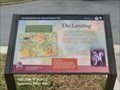 view gallery view galleryNW1.3 km | The Landing Star-Spangled Banner National Historic Trail - Fort Howard MD in Signs of History Transport ships carrying a British invasion force arrived in Old Road Bay, September 11, 1814. posted by: Don.Morfe location: Maryland date approved: 09/01/2022 last visited: 01/16/2023 |
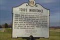 view gallery view gallery N1.6 km N1.6 km
| Todd's Inheritance in Maryland Historical Markers Todd's Farmhouse
Listed 10/18/1973
Address 9000 Old North Point Rd. Ft. Howard, MD
Period of Significance 1800-1824, 1825-1849 posted by: Fritz_Monroe location: Maryland date approved: 03/09/2006 last visited: 08/20/2021 |
 view gallery view galleryN1.6 km | A Heavy Price Star-Spangled Banner National Historic Trail - Sparrows Point, MD in Signs of History Private Bernard Todd paid dearly for having his home used for military purposes. posted by: Don.Morfe location: Maryland date approved: 09/01/2022 last visited: 01/16/2023 |
 view gallery view galleryN1.6 km | A Heavy Price Star-Spangled Banner National Historic Trail - Sparrows Point, MD in War of 1812 Private Bernard Todd paid dearly for having his home used for military purposes. posted by: Don.Morfe location: Maryland date approved: 03/19/2020 last visited: 11/02/2021 |
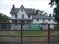 view gallery view galleryN1.6 km | Todd Farmhouse (Fort Howard, Maryland) in Wikipedia Entries In 1664, Thomas Todd made the first purchase of land in what would become over 1000 acres of Baltimore County. During the War of 1812, the house, which overlooks Shallow Creek and the Chesapeake Bay, was used by the Todd family as a lookout point. posted by: Don.Morfe location: Maryland date approved: 09/12/2021 last visited: 01/29/2022 |
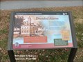
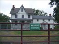 view gallery view galleryN1.6 km |  Todd Farmhouse - Fort Howard MD Todd Farmhouse - Fort Howard MD
in U.S. National Register of Historic Places In 1664, Thomas Todd made the first purchase of land in what would become over 1000 acres of Baltimore County. During the War of 1812, the house, which overlooks Shallow Creek and the Chesapeake Bay, was used by the Todd family as a lookout point. posted by: Don.Morfe location: Maryland date approved: 01/10/2021 last visited: 09/11/2021 |
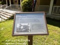
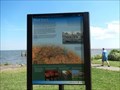
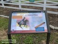
 view gallery view galleryN2.3 km |  Unexpected Resistance - Sparrows Point MD Unexpected Resistance - Sparrows Point MD
in Battlefields The marker is located in North Point State Park on Old Bay Shore Road, Sparrows Point, MD United States 21219. posted by: Don.Morfe location: Maryland date approved: 09/14/2023 last visited: 07/15/2020 |
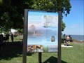
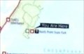 view gallery view galleryN2.3 km |  'You Are Here' Maps-Unexpected Resistance - Sparrows Point MD 'You Are Here' Maps-Unexpected Resistance - Sparrows Point MD
in 'You Are Here' Maps The 'You Are Here' Map shows that you are in North Point State Park on Old Bay Shore Road, Sparrows Point, MD United States 21219. posted by: Don.Morfe location: Maryland date approved: 09/13/2023 last visited: 09/16/2023 |
 view gallery view galleryN2.3 km | Unexpected Resistance Star-Spangled Banner National Historic Trail - Sparrows Point MD in War of 1812 British troops landing at North Point on September 12, 1814, could almost taste victory. Three weeks earlier they defeated the Americans at Bladensburg and invaded Washington. posted by: Don.Morfe location: Maryland date approved: 03/19/2020 last visited: 11/02/2021 |
 view gallery view galleryN2.3 km | Unexpected Resistance Star-Spangled Banner National Historic Trail - Sparrows Point MD in Signs of History British troops landing at North Point on September 12, 1814, could almost taste victory. Three weeks earlier they defeated the Americans at Bladensburg and invaded Washington. posted by: Don.Morfe location: Maryland date approved: 09/01/2022 last visited: 01/16/2023 |
|