 view gallery view gallery SE9.2 km SE9.2 km
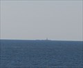
|   Brandywine Shoals Lighthouse - Cape May County, NJ Brandywine Shoals Lighthouse - Cape May County, NJ
in U.S. Benchmarks A benchmark located in the middle of the Delaware Bay. posted by:  Ernmark Ernmark location: New Jersey date approved: 08/06/2009 last visited: 09/19/2015 |
 view gallery view gallery SW13.7 km SW13.7 km
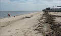
|  Big Stone Beach Big Stone Beach
in Beaches A beach in DE! posted by: ODragon location: Delaware date approved: 09/08/2008 last visited: 09/07/2008 |
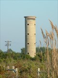
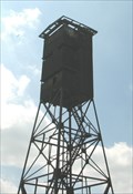 view gallery view gallerySW13.7 km |  Big Stone Beach Look Out Tower Big Stone Beach Look Out Tower
in Military Installations A tower on the beach. posted by: ODragon location: Delaware date approved: 09/08/2008 last visited: 01/13/2023 |
 view gallery view gallerySW13.7 km |  Observation Tower at Big Stone Beach (KC-115) - Milford, DE Observation Tower at Big Stone Beach (KC-115) - Milford, DE
in Delaware Historical Markers Observation Tower at Big Stone Beach-The metal observation tower at Big Stone Beach was one of five constructed in Delaware between World wars I and II to reinforce nearby Fort Saulsbury. posted by:  Don.Morfe Don.Morfe location: Delaware date approved: 11/13/2019 last visited: 10/23/2021 |
 view gallery view gallerySW13.8 km |  Milford Neck - Milford, DE Milford Neck - Milford, DE
in Birdwatching Locations A nice marsh area for watching birds. posted by: ODragon location: Delaware date approved: 09/08/2008 last visited: 09/07/2008 |
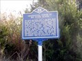
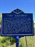 view gallery view gallerySW18.3 km | Fort Saulsbury (S-89) - Milford, DE in Delaware Historical Markers Fort Saulsbury posted by: CronoMkI location: Delaware date approved: 05/29/2022 last visited: never |
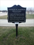 view gallery view gallerySE21.1 km |  Charles W. Sandman Boulevard - Cape May, NJ Charles W. Sandman Boulevard - Cape May, NJ
in New Jersey Historical Markers Marker recounting the dedication of a section of US Hwy 9 to local politician Charles Sandman. posted by: jiggs11 location: New Jersey date approved: 07/22/2018 last visited: 06/06/2019 |
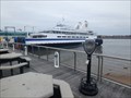
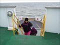 view gallery view gallerySE21.1 km |  Cape May Lewes Ferry Cape May Lewes Ferry
in Ferries and Ferry Landings Welcome aboard! The Cape May-Lewes Ferry is the most memorable way to travel between Delaware and New Jersey. Expand your family vacation experience and leave the driving to the Captain...take the Cape May – Lewes Ferry on a 17-mile, 80 minute voyage across the Delaware Bay and cut miles off your trip along the Atlantic Coast. posted by: chstress53 location: New Jersey date approved: 05/18/2006 last visited: 10/23/2006 |
 view gallery view gallerySE21.1 km |  Binoculars - Cape May Ferry Terminal, NJ Binoculars - Cape May Ferry Terminal, NJ
in Coin-Op Binoculars Stand-up binoculars located next to the Cape May Ferry Terminal. posted by: jiggs11 location: New Jersey date approved: 07/23/2018 last visited: 06/06/2019 |
 view gallery view gallery NE21.1 km NE21.1 km
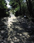
|  East Point Lighthouse Boardwalk East Point Lighthouse Boardwalk
in Eagle Scout Project Sites A muddy area gets a nice boardwalk. posted by: ODragon location: New Jersey date approved: 12/05/2005 last visited: 09/04/2010 |
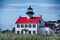 view gallery view galleryNE21.1 km |  Maurice River Lighthouse (East Point Litght ) - NJ Maurice River Lighthouse (East Point Litght ) - NJ
in U.S. National Register of Historic Places The East Point Light, known as the Maurice River Light before 1913, is a lighthouse located in Heislerville, New Jersey on the Delaware Bay at the mouth of the Maurice River in Maurice River Township, Cumberland County, New Jersey. posted by: nomadwillie location: New Jersey date approved: 11/12/2019 last visited: never |
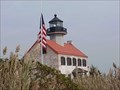 view gallery view galleryNE21.2 km |  East Point Lighthouse East Point Lighthouse
in Coastal Lighthouses Originally known as the Maurice River Lighthouse, it was erected in 1849 by the United States Lighthouse Establishment. The present name was initiated in 1913. Throughout the years its guiding light has shown fisherman, oystermen, and recreational boaters the way into the mouth of the Maurice River. During the daylight hours, it has been used as a landmark by hunters, trappers, and surveyors posted by: chstress53 location: New Jersey date approved: 10/06/2005 last visited: 09/20/2013 |
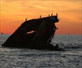
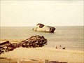 view gallery view gallerySE21.4 km |  Atlantus Atlantus
in Shipwrecks The S. S. Atlantus is probably the most famous concrete ship. She was launched on December 5, 1918, at Wilmington, North Carolina. Commissioned June 1st, 1919. posted by: Old Navy location: New Jersey date approved: 12/06/2005 last visited: 10/22/2016 |
 view gallery view gallerySE21.4 km |  Higbee Beach Parking Area Higbee Beach Parking Area
in Turtle Crossings Higbee beach parking area near Cape May. posted by: Hillbilly Harry location: New Jersey date approved: 01/01/2006 last visited: 09/15/2015 |
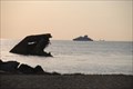
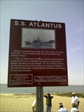 view gallery view gallerySE21.7 km | S.S. Atlantus - Cape May, NJ in New Jersey Historical Markers 150 feet off the coast of Sunset Beach in Cape May, New Jersey, a strange structure sticks out of the water. This historic sign marks this curiosity. Simply park your car where NJ ends and after reading the sign, look out at the water. posted by: Math Teacher location: New Jersey date approved: 05/17/2008 last visited: 10/22/2016 |
 view gallery view gallerySE21.7 km |  S.S. Atlantus - Cape May, NJ S.S. Atlantus - Cape May, NJ
in Roadside Attractions 150 feet off the coast of Sunset Beach in Cape May, New Jersey, a strange structure sticks out of the water. This historic sign marks this curiosity. Simply park your car where NJ ends and after reading the sign, look out at the water. posted by: Math Teacher location: New Jersey date approved: 05/17/2008 last visited: 10/22/2016 |
 view gallery view gallerySE21.7 km |  S.S. Atlantus - Cape May, NJ S.S. Atlantus - Cape May, NJ
in Satellite Imagery Oddities 50 feet off the coast of Sunset Beach in Cape May, New Jersey, a strange structure sticks out of the water. This historic sign marks this curiosity. Simply park your car where NJ ends and after reading the sign, look out at the water. posted by: Math Teacher location: New Jersey date approved: 08/13/2013 last visited: 10/22/2016 |
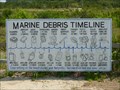 view gallery view gallerySE21.7 km |  Marine Debris Timeline - 6 weeks to 600+ years - Cape May, NJ Marine Debris Timeline - 6 weeks to 600+ years - Cape May, NJ
in Timelines Here is an eye-opening timeline to inform you of how long the products you throw away take to disintegrate in the world's oceans. It is located at Sunset Beach in Cape May, NJ. posted by:  neoc1 neoc1 location: New Jersey date approved: 08/05/2015 last visited: 03/01/2018 |
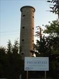
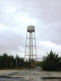 view gallery view gallerySE21.9 km |  Sunset Beach Water Tower - Cape May, NJ Sunset Beach Water Tower - Cape May, NJ
in Water Towers A lone unused tank standing watch near a popular tourist spot on the Jersey Cape. posted by: Ernmark location: New Jersey date approved: 10/24/2013 last visited: 03/01/2018 |
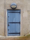 view gallery view gallerySE21.9 km |  World War II Lookout Tower - Cape May, NJ World War II Lookout Tower - Cape May, NJ
in Doorways of the World WW II lookout tower #23, built in 1942, was one of 15 fire towers built as part of the Delaware Harbor Defense. posted by: Janila location: New Jersey date approved: 10/09/2018 last visited: never |
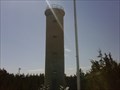 view gallery view gallerySE21.9 km |  World War II Lookout Tower World War II Lookout Tower
in Look-Out Towers Fire Control Tower No. 23. Located on Sunset BLVD. in Cape May Point, NJ.
Parking is directly across the street. posted by: Samshipmate location: New Jersey date approved: 03/27/2011 last visited: 06/25/2018 |
 view gallery view gallerySE21.9 km | Fire Control Tower # 23 - Cape May Point, NJ in Military Installations Abandoned Observation Tower built in 1942 and used during World War II to protect Southern New Jersey & the Delaware Bay - now in the process of undergoing restoration. posted by: Ernmark location: New Jersey date approved: 09/29/2008 last visited: 10/22/2016 |
 view gallery view gallerySE21.9 km | Fire Control Tower # 23 - Cape May Point, NJ in U.S. National Register of Historic Places Abandoned Observation Tower built in 1942 and used during World War II to protect Southern New Jersey & the Delaware Bay - now in the process of undergoing restoration.
posted by: Ernmark location: New Jersey date approved: 09/30/2008 last visited: 10/22/2016 |
 view gallery view gallery E22.4 km E22.4 km
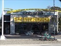
|  McDonald's - Bayshore Rd - North Cape May, NJ McDonald's - Bayshore Rd - North Cape May, NJ
in McDonald's Restaurants This is the McDonald's location in North Cape May, NJ. posted by: retail96 location: New Jersey date approved: 11/16/2018 last visited: 06/06/2019 |
 view gallery view galleryE22.5 km |  Turdo Vineyards & Winery Turdo Vineyards & Winery
in Wineries Turdo Vinyards very first vines were planted in 1999... and a year later over 5,000 vines were planted. posted by: chstress53 location: New Jersey date approved: 12/14/2005 last visited: 10/08/2017 |
|