 view gallery view gallery NE5.3 km NE5.3 km
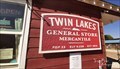
|   Twin Lakes General Store -Twin Lakes, CO (9,236 ft) Twin Lakes General Store -Twin Lakes, CO (9,236 ft)
in Elevation Signs Sign is located on side of The Twin Lakes General Store Mercantile right next to the entrance. posted by:  mr.volkswagen mr.volkswagen location: Colorado date approved: 09/14/2021 last visited: never |
 view gallery view gallery SE6.4 km SE6.4 km
|  Vicksburg, Colorado Vicksburg, Colorado
in Ghost Towns A silver mining town from the late 1800s posted by:  sherpes sherpes location: Colorado date approved: 08/02/2010 last visited: never |
 view gallery view gallery S6.9 km S6.9 km
| Winfield, Colorado in Ghost Towns Now the half-way point of the famous Leadville 100 running race posted by: sherpes location: Colorado date approved: 08/02/2010 last visited: never |
 view gallery view galleryS6.9 km |  Mt Huron 1994 Helicopter Crash, Colorado Mt Huron 1994 Helicopter Crash, Colorado
in Disaster Memorials Mountain rescue attempt in which pilot and flight nurse perished posted by: sherpes location: Colorado date approved: 07/31/2010 last visited: never |
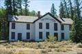 view gallery view galleryNE7.2 km |  Interlaken Resort District - Twin Lakes CO Interlaken Resort District - Twin Lakes CO
in U.S. National Register of Historic Places Interlaken Resort District is located on the the south side of Twin Lakes. posted by: mr.volkswagen location: Colorado date approved: 09/14/2021 last visited: never |
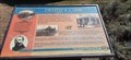 view gallery view galleryNE7.4 km |  Dexter's Cabin - Twin Lakes, CO Dexter's Cabin - Twin Lakes, CO
in Colorado Historical Markers Dexter's Cabin is located on the Interlaken Trail on the south side of Twin Lakes in near Twin Lakes, CO in Lake County. posted by: mr.volkswagen location: Colorado date approved: 09/14/2021 last visited: never |
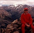
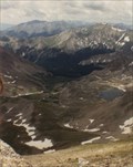
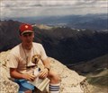
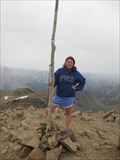 view gallery view gallery N8.4 km N8.4 km
|  Highest Point in Colorado (Mount Elbert) Highest Point in Colorado (Mount Elbert)
in Geographic High Points Highest of the Colorado 14ers! posted by:  Web-ling Web-ling location: Colorado date approved: 12/01/2008 last visited: 07/16/2010 |
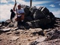
 view gallery view galleryN8.4 km |  Mount Elbert Mount Elbert
in Wikipedia Entries The highest point in Colorado! posted by: Web-ling location: Colorado date approved: 11/28/2009 last visited: 08/26/2010 |
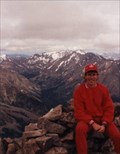 view gallery view galleryN8.4 km |  Mount Elbert Mount Elbert
in Mountain Summits The highest point in Colorado! posted by: Web-ling location: Colorado date approved: 10/13/2006 last visited: 07/16/2010 |
 view gallery view gallery E10.1 km E10.1 km
|  Interlaken Trail - Twin Lakes, CO Interlaken Trail - Twin Lakes, CO
in Mountain Bike Trailheads Located on the south side of Twin Lakes. posted by: mr.volkswagen location: Colorado date approved: 09/14/2021 last visited: never |
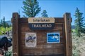
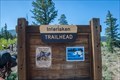 view gallery view galleryE10.1 km |  Interlaken Trailhead - Twin Lakes, CO Interlaken Trailhead - Twin Lakes, CO
in Hiking and walking trailheads Located on the south side of Twin Lakes. posted by: mr.volkswagen location: Colorado date approved: 09/13/2021 last visited: never |
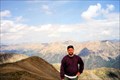 view gallery view gallerySE10.8 km | Mount Belford in Mountain Summits Mount Belford is the 18th highest point in Colorado and is located in the Sawatch range of the Rocky Mountains between Leadville and Buena Vista. posted by: DrPowercat location: Colorado date approved: 09/07/2009 last visited: never |
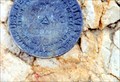 view gallery view gallerySE10.8 km |  Mount Belford Benchmark Mount Belford Benchmark
in U.S. Benchmarks This benchmark is at the top of a 14,197 foot mountain in the Sawatch Range of the Rocky Mountains. posted by: DrPowercat location: Colorado date approved: 09/06/2009 last visited: never |
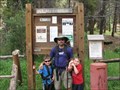 view gallery view galleryN11.9 km | Mt. Massive Trailhead, Halfmoon Creek in Hiking and walking trailheads This trailhead is at 10,073 feet above sea level and will take you to the top of the second highest 14er in Colorado. posted by: DrPowercat location: Colorado date approved: 08/23/2009 last visited: 07/25/2009 |
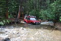
 view gallery view gallery NW12.4 km NW12.4 km
|  Halfmoon Creek Crossing - Leadville, CO Halfmoon Creek Crossing - Leadville, CO
in Bridgeless Water Crossings Halfmoon Creek Trail runs through the San Isabel National Forest, just outside of Leadville, Colorado. Be prepared, crossing the Halfmoon Creek here can be very deep depending on recent rains. posted by: 94RedRover location: Colorado date approved: 01/25/2010 last visited: never |
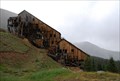 view gallery view galleryNW12.6 km |  Champion Mill - Leadville, CO Champion Mill - Leadville, CO
in Mills and Gins Champion Mill is part of a mining complex on the eastern slope of Mount Champion outside Leadville, Colorado. posted by: 94RedRover location: Colorado date approved: 12/08/2009 last visited: never |
 view gallery view galleryNW12.7 km | Halfmoon Creek Crossing #2 - Leadville, CO in Bridgeless Water Crossings Halfmoon Creek Trail runs through the San Isabel National Forest just southwest of Leadville, Colorado. This easy stream crossing occurs near the beginning of the trail. posted by: 94RedRover location: Colorado date approved: 01/25/2010 last visited: never |
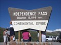 view gallery view galleryNW14.2 km | Independence Pass, Colorado in Elevation Signs Independence Pass, one of the most frightening roads in Colorado posted by: ronjean location: Colorado date approved: 09/07/2008 last visited: 10/01/2022 |
 view gallery view galleryN15.9 km |  Halfmoon Creek - Leadville, CO Halfmoon Creek - Leadville, CO
in Offroad Trails Loacted southwest of Leadville, this trail leads up to an elevation of 12,800 feet, from open plains and numerous creek crossings and ends at the hisotirc Iron Mike Mine. posted by: 94RedRover location: Colorado date approved: 09/14/2009 last visited: never |
 view gallery view gallerySE15.9 km | Mount Harvard - Wikipedia in Wikipedia Entries Third highest point in Colorado posted by: Web-ling location: Colorado date approved: 11/27/2009 last visited: never |
 view gallery view gallerySE15.9 km | Harvard, Mount in Mountain Summits One of the may Colorado 14er's posted by: t-xman location: Colorado date approved: 09/10/2005 last visited: 07/31/2007 |
 view gallery view gallerySE15.9 km | Chaffee County, Colorado Highpoint (Mount Harvard) in Geographic High Points 3rd highest point in Colorado. posted by: Web-ling location: Colorado date approved: 12/01/2008 last visited: 08/24/2009 |
 view gallery view galleryN16.4 km | Mount Massive in Mountain Summits Second-highest point in Colorado! posted by: Web-ling location: Colorado date approved: 10/14/2006 last visited: 08/03/1999 |
 view gallery view galleryN16.4 km | Mount Massive in Wikipedia Entries Second-highest point in Colorado! posted by: Web-ling location: Colorado date approved: 11/28/2009 last visited: never |
 view gallery view galleryNE17.1 km | Weston Pass - Leadville, CO in Offroad Trails Weston Pass, which once carried mining supplies and travelers over the Weston Peak from Fairplay and Leadville, crosses at 11,921 feet. posted by: 94RedRover location: Colorado date approved: 08/17/2009 last visited: 09/19/2015 |
|