 view gallery view gallery NW4.7 km NW4.7 km
|   Slate Mills Slate Mills
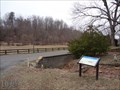
in Civil War Discovery Trail Sites Slate Mills in Rappahannock County, VA was used by both the Union and Confederate armies for reconnaissance. The road was used by troops retreating from Gettysburg and by Confederate soldiers headed to Bristoe Station. posted by:  La de Boheme La de Boheme location: Virginia date approved: 03/27/2013 last visited: never |
 view gallery view gallery N8 km N8 km
|  John Jackson Traditional Musician John Jackson Traditional Musician
in Virginia Historical Markers This historic marker is located on Route 522 near the community of Woodville, Virginia posted by:  Sneakin Deacon Sneakin Deacon location: Virginia date approved: 08/30/2010 last visited: 02/29/2020 |
 view gallery view galleryN8.2 km |  Pet In A Churchyard - Woodville VA Pet In A Churchyard - Woodville VA
in Out of Place Graves The beloved cat of the Colliers was buried in a church cemetery. posted by: La de Boheme location: Virginia date approved: 02/28/2012 last visited: 01/18/2014 |
 view gallery view galleryN8.2 km |  Frank McGee - Woodville, Va. Frank McGee - Woodville, Va.
in Grave of a Famous Person Frank McGee was a Peabody Award winning journalist who worked for NBC News from the early 1950’s through the mid 1970’s posted by: Sneakin Deacon location: Virginia date approved: 07/12/2016 last visited: never |
 view gallery view galleryN8.2 km | Eugene J. McCarthy in Grave of a Famous Person McCarthy was a renown politician and presidential candidate from MN. posted by: La de Boheme location: Virginia date approved: 02/27/2012 last visited: 07/12/2016 |
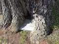 view gallery view galleryN8.2 km |  Monster Tombstone-Crunching Tree Monster Tombstone-Crunching Tree
in Omnivorous Trees A mighty tree threatens to engulf an entire headstone in a cemetery in Woodville, VA. posted by: La de Boheme location: Virginia date approved: 02/25/2012 last visited: 09/20/2015 |
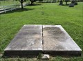
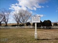 view gallery view galleryN8.2 km |  St. Paul's Episcopal Cemetery - Woodville VA St. Paul's Episcopal Cemetery - Woodville VA
in Churchyard Cemeteries St. Paul's Episcopal Church was destroyed in a tornado but the churchyard survived. posted by: La de Boheme location: Virginia date approved: 02/25/2012 last visited: 07/10/2016 |
 view gallery view galleryN8.4 km | Mosby and Sneden in Civil War Discovery Trail Sites Artist and mapmaker Union Pvt. Sneden was captured by Mosby's Rangers at Brandy Station and marched through Woodville, VA as a POW. posted by: La de Boheme location: Virginia date approved: 02/28/2012 last visited: 07/10/2016 |
 view gallery view gallery S10.5 km S10.5 km
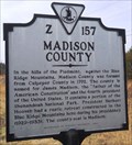
| Madison County / Culpeper County in Virginia Historical Markers County line marker teaches us that Culpeper County was formed from Orange County, and then Madison County from part of Culpeper County. posted by: vhasler location: Virginia date approved: 03/17/2012 last visited: 09/15/2012 |
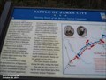
 view gallery view galleryS10.9 km | Battle of James City-Opening Battle of the Bristoe Station Campaign - Leon VA in U.S. Civil War Sites On October 10, 1863, Confederate Gen. Robert E. Lee, anticipating an offensive that became known as the Bristoe Station Campaign, sent a division of Confederate horsemen led by Gen. J.E.B. Stuart north from Madison on a raid. posted by: Don.Morfe location: Virginia date approved: 06/22/2023 last visited: 06/22/2023 |
 view gallery view galleryS10.9 km |  ONLY - Instance During the Civil War Gen. J.E.B. Stuart led a force completely without Virginians - Battle of James City VA ONLY - Instance During the Civil War Gen. J.E.B. Stuart led a force completely without Virginians - Battle of James City VA
in Superlatives Battle of James City-Opening Battle of the Bristoe Station Campaign-This was the only instance during the war when Stuart led a force completely without Virginians. posted by: Don.Morfe location: Virginia date approved: 08/07/2023 last visited: 08/07/2023 |
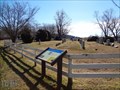
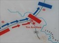 view gallery view galleryS10.9 km |  You Are Here Maps-Battle of James City - Leon VA You Are Here Maps-Battle of James City - Leon VA
in 'You Are Here' Maps The You Are Here map shows that you are on Leon Road (VA Route 631) in Leon VA. posted by: Don.Morfe location: Virginia date approved: 08/06/2023 last visited: 08/07/2023 |
 view gallery view galleryS10.9 km | Battle of James City-Opening Battle of the Bristoe Station Campaign - Leon VA in Civil War Discovery Trail Sites On October 10, 1863, Confederate Gen. Robert E. Lee, anticipating an offensive that became known as the Bristoe Station Campaign, sent a division of Confederate horsemen led by Gen. J.E.B. Stuart north from Madison on a raid. posted by: Don.Morfe location: Virginia date approved: 07/05/2020 last visited: 10/05/2021 |
 view gallery view galleryS10.9 km |  Battle of James City - Leon VA Battle of James City - Leon VA
in Battlefields As Stuart approached, the Union troops withdrew to a position across Crooked Run in Culpeper County. They drew up in line of battle on a hill overlooking James City, with their artillery ready to confront Stuart, should he advance. posted by: Don.Morfe location: Virginia date approved: 11/09/2020 last visited: 10/16/2021 |
 view gallery view galleryNW11.4 km |  Weakley Hollow Fire Road Bridges ~ Old Rag Mtn, Shenandoah NP, VA Weakley Hollow Fire Road Bridges ~ Old Rag Mtn, Shenandoah NP, VA
in Hiking Path Footbridges Departing the Old Rag Mountain upper parking lot, the Weakley Hollow fire road has 3 foot bridges running parallel to it to get hikers across streams that a vehicle would drive through. posted by: garmin_geek location: Virginia date approved: 01/26/2009 last visited: 05/10/2014 |
 view gallery view gallery W12.1 km W12.1 km
|  Old Rag Mountain - Shenandoah NP, VA Old Rag Mountain - Shenandoah NP, VA
in Mountain Summits One of the most popular day hike in the Shenandoah NP. Panoramic summit view. A very challenging 8.8 mile circuit hike and rock scramble with 2200 - 2400 feet of elevation gain depending on which parking lot you use. posted by: garmin_geek location: Virginia date approved: 01/20/2009 last visited: 05/10/2014 |
 view gallery view galleryW12.1 km |  Summit Old Rag Mtn, 3291', Shenandoah NP, VA Summit Old Rag Mtn, 3291', Shenandoah NP, VA
in Elevation Signs Summit sign for Old Rag Mtn, 3291 posted by: garmin_geek location: Virginia date approved: 01/30/2009 last visited: 05/10/2014 |
 view gallery view galleryNW12.2 km |  Broad Hollow Homesite - Shenandoah National Park VA Broad Hollow Homesite - Shenandoah National Park VA
in Remains of Settlements The ruins of an old home stand near a trail in the Blue Ridge Mountains of Virginia. posted by: La de Boheme location: Virginia date approved: 12/25/2010 last visited: never |
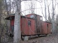 view gallery view galleryNW13.5 km |  N&W Caboose - Sperryville VA N&W Caboose - Sperryville VA
in Train Cabooses A caboose from Luray, VA. has reached the end of the line in Sperryville, VA. posted by: La de Boheme location: Virginia date approved: 03/07/2012 last visited: never |
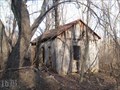 view gallery view galleryNW13.7 km |  Abandoned Shack - Sperryville VA Abandoned Shack - Sperryville VA
in Unoccupied Buildings, Shacks, and Cabins An old dilapidated wooden building sits on a mountainside. posted by: La de Boheme location: Virginia date approved: 03/05/2012 last visited: never |
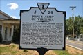 view gallery view galleryN14.5 km | Pope's Army of Virginia in Virginia Historical Markers This historic marker stands on Route 522 in Sperryville, Va. posted by: Sneakin Deacon location: Virginia date approved: 09/27/2010 last visited: 02/29/2020 |
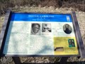 view gallery view galleryN14.8 km | Sister Caroline in Civil War Discovery Trail Sites Caroline Terry was born a slave and witnessed Union and Confederate encampments in Sperryville, VA during the Civil War. After her emancipation, she remained in the area and helped establish a church. posted by: La de Boheme location: Virginia date approved: 02/21/2012 last visited: never |
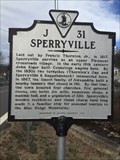 view gallery view galleryN15 km | Sperryville - Sperryville, VA in Virginia Historical Markers Sperryville lies at the intersection of two old toll roads near the Blue Ridge Mountains. posted by: Go Boilers! location: Virginia date approved: 03/03/2020 last visited: never |
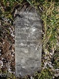
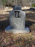 view gallery view galleryNW15 km |  108 - Caroline Terry - Sperryville VA 108 - Caroline Terry - Sperryville VA
in Headstones of Centenarians Born a slave and died a free woman, Sister Caroline, spent most of her life in Rappahannock County, VA and was buried in the cemetery of a church she helped organized. posted by: La de Boheme location: Virginia date approved: 02/22/2012 last visited: never |
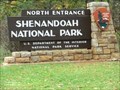 view gallery view galleryW15.1 km |  Shenandoah National Park - Front Royal VA Shenandoah National Park - Front Royal VA
in Wikipedia Entries The park is best known for Skyline Drive, a 105-mile (169 km) road that runs the length of the park along the ridge of the mountains. posted by: Don.Morfe location: Virginia date approved: 02/11/2024 last visited: 02/11/2024 |
|