 view gallery view gallery N0.8 km N0.8 km
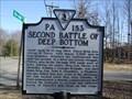
|   Second Battle of Deep Bottom Second Battle of Deep Bottom
in Virginia Historical Markers The August 1864 battle that took place near this location is described. posted by:  archway archway location: Virginia date approved: 02/06/2010 last visited: never |
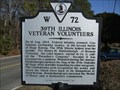 view gallery view galleryN0.8 km | 39th Illinois Veteran Volunteers in Virginia Historical Markers The brave action of a Medal of Honor recipient is described on this marker. posted by: archway location: Virginia date approved: 01/05/2010 last visited: never |
 view gallery view gallery NE1.1 km NE1.1 km
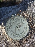
|  MALVERN RESET - Henrico, VA MALVERN RESET - Henrico, VA
in U.S. Benchmarks Triangulation station located on Darbytown Road east of Richmond. posted by: archway location: Virginia date approved: 01/30/2010 last visited: never |
 view gallery view gallery SW2.4 km SW2.4 km
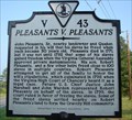
| Pleasants v. Pleasants in Virginia Historical Markers Court case over manumissions ruled in favor of freeing the slaves. posted by: VirginiaSeeker location: Virginia date approved: 09/10/2006 last visited: 05/17/2019 |
 view gallery view gallery E2.6 km E2.6 km
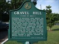
| Gravel Hill in Virginia Historical Markers A Henrico County historical marker located at Gravel Hill Community Center. posted by: archway location: Virginia date approved: 09/02/2009 last visited: never |
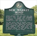 view gallery view gallerySW2.7 km | New Market Road in Virginia Historical Markers An Henrico County historical marker on Route 5 west of I295 posted by: Taluss location: Virginia date approved: 11/16/2008 last visited: 05/17/2019 |
 view gallery view gallery S3.1 km S3.1 km
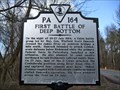
| First Battle of Deep Bottom in Virginia Historical Markers The battle described on this marker was part of the Siege of Petersburg. The Union lost the battle, but successfully drew Confederates away from Petersburg to defend Richmond. posted by: archway location: Virginia date approved: 02/06/2010 last visited: 05/17/2019 |
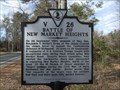 view gallery view gallerySW3.2 km | Battle of New Market Heights in Virginia Historical Markers Marker describing the Union capture of New Market Heights and the Medal of Honor recipients who fought the battle. posted by: archway location: Virginia date approved: 02/06/2010 last visited: 05/17/2019 |
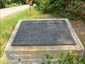
 view gallery view galleryE3.2 km |  Frazier’s Farm - Richmond, VA Frazier’s Farm - Richmond, VA
in Signs of History Placed by the Battlefield Markers Association, marker #18 indicates the location where Confederate General James Longstreet engaged Union forces and where the heaviest fighting took place during the Battle of Glendale. posted by: archway location: Virginia date approved: 01/13/2010 last visited: never |
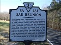 view gallery view galleryN3.5 km | Sad Reunion in Virginia Historical Markers A story about the meeting of Confederate and Union Generals near this location in 1864 is described on this marker. posted by: archway location: Virginia date approved: 02/06/2010 last visited: never |
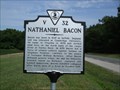 view gallery view galleryS3.7 km | Nathaniel Bacon in Virginia Historical Markers One of two historical markers describing colonial events. posted by: archway location: Virginia date approved: 12/07/2009 last visited: 05/17/2019 |
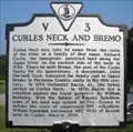 view gallery view galleryS3.7 km | Curles Neck and Bremo in Virginia Historical Markers Curles Neck may take its name from the curls of the river or a family of that name. posted by: VirginiaSeeker location: Virginia date approved: 09/11/2006 last visited: 05/17/2019 |
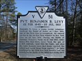 view gallery view galleryE3.7 km | Pvt. Benjamin B. Levy in Virginia Historical Markers Pvt. Levy fought at the Battle of Glendale in June 1862 and earned the Medal of Honor for his actions. posted by: archway location: Virginia date approved: 02/06/2010 last visited: never |
 view gallery view galleryE3.7 km | Frazier’s Farm - Richmond, VA in Signs of History Placed by the Battlefield Markers Association, marker #17 marks the location around Darbytown Road where intense fighting took place during the Battle of Glendale on June 30, 1862. posted by: archway location: Virginia date approved: 01/13/2010 last visited: never |
 view gallery view galleryE3.7 km |  Frazier's Farm or Glendale Battlefield - Glendale VA Frazier's Farm or Glendale Battlefield - Glendale VA
in U.S. Civil War Sites North and South of this point lay the line of battle in which the Confederate commands of James Longstreet and A.P. Hill engaged indecisively the Federal forces in the Fourth Battle of the Seven Days’ Campaign. posted by:  Don.Morfe Don.Morfe location: Virginia date approved: 09/18/2020 last visited: 10/02/2021 |
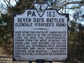 view gallery view galleryE3.9 km | Seven Days Battles - Glendale (Frayser's Farm) in Virginia Historical Markers The Confederate line was located here during the Battle of Glendale, June 30, 1862. posted by: archway location: Virginia date approved: 01/05/2010 last visited: never |
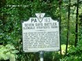 view gallery view galleryE3.9 km | Seven Days Battles Glendale (Frayser's Farm) - Henrico VA in American Civil War Monuments and Memorials The marker is on Darbytown Road, Henrico VA 23231 in Henrico County. It was erected 1932 by Conservation & Development Commission. (Marker Number PA-163.) posted by: Don.Morfe location: Virginia date approved: 08/02/2023 last visited: 08/02/2023 |
 view gallery view gallery W4 km W4 km
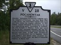
| Pocahontas in Virginia Historical Markers First of five historical markers grouped together at the Route 5 / I-295 interchange. posted by: archway location: Virginia date approved: 10/15/2009 last visited: 05/16/2019 |
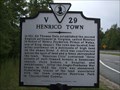 view gallery view galleryW4 km | Henrico Town in Virginia Historical Markers Second of five historical markers grouped together at the Route 5 / I-295 interchange. posted by: archway location: Virginia date approved: 10/15/2009 last visited: 05/16/2019 |
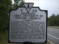 view gallery view galleryW4 km | Proposed First University In English America in Virginia Historical Markers Third of five historical markers grouped together at the Route 5 / I-295 interchange. posted by: archway location: Virginia date approved: 10/15/2009 last visited: 05/16/2019 |
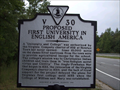 view gallery view galleryW4 km |  First Proposed University in America – Henrico Co., VA First Proposed University in America – Henrico Co., VA
in First of its Kind The first attempt at establishing an institution of higher education in the New World was at the Citie of Henricus, the second English settlement after Jamestown. posted by: archway location: Virginia date approved: 12/14/2009 last visited: 05/16/2019 |
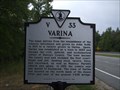 view gallery view galleryW4 km | Varina in Virginia Historical Markers Fourth of five historical markers grouped together at the Route 5 / I-295 interchange. posted by: archway location: Virginia date approved: 10/15/2009 last visited: 05/16/2019 |
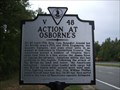 view gallery view galleryW4 km | Action at Osborne's in Virginia Historical Markers Fifth of five historical markers grouped together at the Route 5 / I-295 interchange. posted by: archway location: Virginia date approved: 10/15/2009 last visited: 05/16/2019 |
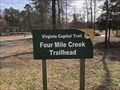 view gallery view galleryW4 km |  Four Mile Creek Trailhead - Richmond, Virginia Four Mile Creek Trailhead - Richmond, Virginia
in Hiking and walking trailheads Located east of I-295 along the north side of New Market Road. posted by: flyingmoose location: Virginia date approved: 07/26/2022 last visited: never |
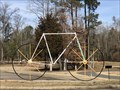 view gallery view galleryW4 km |  Big Bike - Richmond, Virginia Big Bike - Richmond, Virginia
in Realistic Object Sculptures Located at the Virginia Capital Trail Parking Lot along the westbound side of New Market Road prior to 295. posted by: flyingmoose location: Virginia date approved: 07/26/2022 last visited: never |
|