 view gallery view gallery W2.3 km W2.3 km
|   MILAN NO 3 - Sumner County, Kansas MILAN NO 3 - Sumner County, Kansas
in U.S. Benchmarks Reference mark 3 for triangulation station MILAN RESET. posted by:  Tom.dog Tom.dog location: Kansas date approved: 11/17/2022 last visited: never |
 view gallery view galleryW2.3 km | MILAN RESET (HF1367) - Sumner County, Kansas in U.S. Benchmarks An NGS triangulation station / horizontal control disk on the north side of W 20th St S. posted by: Tom.dog location: Kansas date approved: 11/17/2022 last visited: never |
 view gallery view galleryW2.3 km | MILAN NO 1 - Sumner County, Kansas in U.S. Benchmarks Reference mark 1 for triangulation station MILAN RESET on the south side of W 20th St S. posted by: Tom.dog location: Kansas date approved: 11/17/2022 last visited: never |
 view gallery view gallery E3.7 km E3.7 km
| MAYFIELD RM 3 (HF1500) - Sumner County, Kansas in U.S. Benchmarks A reference mark for triangulation station MAYFIELD on the south end of the town of Mayfield, Kansas. posted by: Tom.dog location: Kansas date approved: 10/30/2022 last visited: 02/19/2022 |
 view gallery view galleryE3.7 km | MAYFIELD (HF0767) - Sumner County, Kansas in U.S. Benchmarks A triangulation station on the south side of the town of Mayfield, Kansas. posted by: Tom.dog location: Kansas date approved: 10/30/2022 last visited: never |
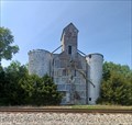
 view gallery view galleryE3.7 km |  Mayfield Standpipe - Mayfield, KS Mayfield Standpipe - Mayfield, KS
in Water Towers This fine standpipe serves the small town of Mayfield, Kansas. posted by: The Snowdog location: Kansas date approved: 02/20/2022 last visited: never |
 view gallery view galleryE3.7 km | MAYFIELD RM 1 (HF0769) - Sumner County, Kansas in U.S. Benchmarks A reference mark for triangulation station MAYFIELD on the south end of the town of Mayfield, Kansas. posted by: Tom.dog location: Kansas date approved: 10/30/2022 last visited: never |
 view gallery view gallery SE4 km SE4 km
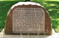
|  Chisholm Trail Marker - Mayfield, KS Chisholm Trail Marker - Mayfield, KS
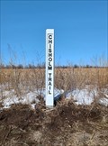
in Wagon Roads and Trails This Chisholm Trail Marker is on the north side of a country road southwest of Mayfield, Kansas. posted by: The Snowdog location: Kansas date approved: 02/20/2022 last visited: never |
 view gallery view galleryE4.2 km |  Osborne Township Cemetery - Mayfield, KS Osborne Township Cemetery - Mayfield, KS
in Worldwide Cemeteries Osborne Township Cemetery is on the east edge of Mayfield, Kansas. posted by: The Snowdog location: Kansas date approved: 02/19/2022 last visited: never |
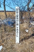
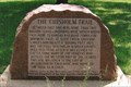
 view gallery view galleryE4.3 km | Chisholm Trail Marker - Mayfield, KS in Wagon Roads and Trails This Chisholm Trail Marker is on the north side of the road, just east of Mayfield, Kansas. posted by: The Snowdog location: Kansas date approved: 04/06/2022 last visited: never |
 view gallery view galleryE4.8 km | FIELD RM 4 (HF1499) - Sumner County, Kansas in U.S. Benchmarks Reference mark 4 for triangulation station FIELD. posted by: Tom.dog location: Kansas date approved: 11/17/2022 last visited: never |
 view gallery view galleryE5 km |  FIRST - Building in Sumner County, KS FIRST - Building in Sumner County, KS
in First of its Kind It looks like this was a roadside park at one time, now just a grass area, neatly kept, with circular gravel drive entering and exiting. Research seems to indicate this was once a US Highway. posted by: YoSam. location: Kansas date approved: 05/21/2019 last visited: 04/28/2022 |
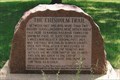
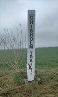
 view gallery view galleryE5 km |  The Chisholm Trail The Chisholm Trail
in Kansas Historical Markers It looks like this was a roadside park at one time, now just a grass area, neatly kept, with circular gravel drive entering and exiting. posted by: YoSam. location: Kansas date approved: 07/07/2010 last visited: 04/28/2022 |
 view gallery view galleryE5 km | The Chisholm Trail - near Wellington, KS in Wagon Roads and Trails It looks like this was a roadside park at one time, now just a grass area, neatly kept, with circular gravel drive entering and exiting posted by: YoSam. location: Kansas date approved: 03/28/2015 last visited: 04/28/2022 |
 view gallery view galleryE5 km |  The Chisholm Trail - near Wellington, KS, USA The Chisholm Trail - near Wellington, KS, USA
in Daughters of the American Revolution It looks like this was a roadside park at one time, now just a grass area, neatly kept, with circular gravel drive entering and exiting. posted by: YoSam. location: Kansas date approved: 05/06/2023 last visited: never |
 view gallery view gallery S5.3 km S5.3 km
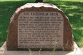
| Chisholm Trail Marker - Mayfield, KS in Wagon Roads and Trails This Chisholm Trail marker is southwest of Mayfield, Kansas. posted by: The Snowdog location: Kansas date approved: 04/27/2022 last visited: never |
 view gallery view galleryS5.3 km | Chicaskia Cemetery - Mayfield, KS in Worldwide Cemeteries This former churchyard cemetery is about four miles southwest of Mayfield, Kansas. posted by: The Snowdog location: Kansas date approved: 04/27/2022 last visited: never |
 view gallery view galleryW7.7 km |  Milan, Kansas - 67105 Milan, Kansas - 67105
in U.S. Post Offices Small town, small post office. posted by: YoSam. location: Kansas date approved: 09/01/2010 last visited: never |
 view gallery view galleryS10.3 km | Sacred Heart Cemetery - Perth, KS in Worldwide Cemeteries This small Catholic cemetery is a few miles west of Perth, Kansas. posted by: The Snowdog location: Kansas date approved: 05/20/2023 last visited: never |
 view gallery view gallerySE11.9 km | Perth S P Wallingford Elevator (HF1382) - Perth, KS in U.S. Benchmarks The westmost of these two grain elevators is U.S. Benchmark HF1382 - in Perth, Kansas. posted by: The Snowdog location: Kansas date approved: 05/26/2023 last visited: never |
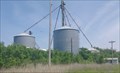 view gallery view gallerySE11.9 km |  Grain Elevators - Perth, KS Grain Elevators - Perth, KS
in Grain Elevators This small complex of grain elevators serve farmers in and around Perth, Kansas. posted by: The Snowdog location: Kansas date approved: 05/21/2023 last visited: never |
 view gallery view gallerySE12.6 km |  Jack and Amelia Dowis - Perth, KS Jack and Amelia Dowis - Perth, KS
in Citizen Memorials A plaque on tis brick pillar indicates that it is set in memory of Jack and Amelia Dowis - in Perth, Kansas. posted by: The Snowdog location: Kansas date approved: 05/21/2023 last visited: never |
 view gallery view gallerySE12.6 km | Bethany Cemetery - Perth, KS in Worldwide Cemeteries Bethany Cemetery is on the east side of Perth, Kansas. posted by: The Snowdog location: Kansas date approved: 05/20/2023 last visited: never |
 view gallery view galleryE14.8 km |  Welcome to Wellington - Wellington, KS Welcome to Wellington - Wellington, KS
in Artistic Welcome Signs This stone and wood welcome sign is on the west side of Wellington, Kansas. posted by: The Snowdog location: Kansas date approved: 04/28/2022 last visited: never |
 view gallery view galleryW15.6 km |  Argona City Park - Argona, OK Argona City Park - Argona, OK
in Public Playgrounds This small park has plenty to keep the young 'uns occupied - in Argona, Oklahoma. posted by: The Snowdog location: Oklahoma date approved: 03/01/2024 last visited: never |
|