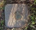
 view gallery view gallery E10.5 km E10.5 km
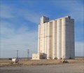
|   SITKA WALLINGFORD GRAIN ELEV (HG0972) - Sitka, KS SITKA WALLINGFORD GRAIN ELEV (HG0972) - Sitka, KS
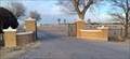
in U.S. Benchmarks The Sitka / Wallingford Grain Elevator is almost all that remains of the ghost town of Sitka, Kansas. posted by:  The Snowdog The Snowdog location: Kansas date approved: 12/28/2022 last visited: never |
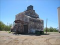
 view gallery view galleryE10.5 km |  Siska / Wallingford Grain Elevator - Siska, KS Siska / Wallingford Grain Elevator - Siska, KS
in Grain Elevators This grain elevator serves farmers in the area of Sitka, Kansas. posted by: The Snowdog location: Kansas date approved: 12/28/2022 last visited: never |
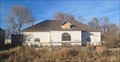 view gallery view galleryE10.6 km |  Sitka Social Club - Sitka, KS Sitka Social Club - Sitka, KS
in Unoccupied Buildings, Shacks, and Cabins Once the center of activity, the Sitka Social Club is abandoned and falling into ruin - in Sitka, Kansas. posted by: The Snowdog location: Kansas date approved: 12/28/2022 last visited: never |
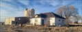 view gallery view galleryE10.6 km |  Sitka, KS Sitka, KS
in Ghost Towns Once a water stop on the railroad, Sitka is now a ghost town - in Clark County, Kansas. posted by: The Snowdog location: Kansas date approved: 12/28/2022 last visited: never |
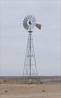 view gallery view gallery W19.5 km W19.5 km
|  Little Basin Windmill - Clark County, KS Little Basin Windmill - Clark County, KS
in Windmills This lonely windmill, atop a ridge between Big Basin and Little Basin, is still pumping water - in Clark County, Kansas. posted by: The Snowdog location: Kansas date approved: 11/22/2022 last visited: never |
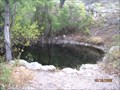 view gallery view galleryW19.6 km |  St Jacob's Well St Jacob's Well
in Natural Sinkholes A fenced pool of water never known to have gone dry contained in Little Basin and accessable by a rough gravel track and trail east of US 283, south of Dodge City. posted by:  boisfort boisfort location: Kansas date approved: 04/29/2007 last visited: 11/19/2022 |
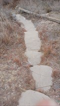 view gallery view galleryW19.6 km |  St. Jacob's Well Stairs - Clark County, KS St. Jacob's Well Stairs - Clark County, KS
in Outdoor Stairways These stone steps lead from the parking area down to St. Jacob's Well - in Clark County, Kansas. posted by: The Snowdog location: Kansas date approved: 11/27/2022 last visited: never |
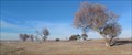
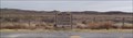 view gallery view galleryW21.1 km | Big Basin - Clark County, KS in Natural Sinkholes These coordinates bring you to a Kansas Historical Marker on the east side of Highway 283, near the center of Big Basin - in Clark County, Kansas. posted by: The Snowdog location: Kansas date approved: 12/03/2022 last visited: never |
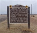 view gallery view galleryW21.1 km |  Big Basin - Clark County, KS Big Basin - Clark County, KS
in Kansas Historical Markers This Kansas Historical Marker is at a large pull-out on the east side of Highway 283, in the middle of Big Basin - in Clark County, Kansas. posted by: The Snowdog location: Kansas date approved: 11/21/2022 last visited: never |
 view gallery view gallery SE24.5 km SE24.5 km
|  Oklahoma / Kansas on US 183 - north of Buffalo, OK Oklahoma / Kansas on US 183 - north of Buffalo, OK
in Border Crossings US 183 joins Oklahoma and Kansas at a small roadside park - north of Buffalo, Oklahoma. posted by: The Snowdog location: Oklahoma date approved: 12/28/2022 last visited: never |
 view gallery view gallerySE24.6 km |  State Line Park - Harper County, OK State Line Park - Harper County, OK
in Highway Rest Areas State Line Park is on the east side of US 183, just south of the Oklahoma / Kansas border - in Harper County, Oklahoma. posted by: The Snowdog location: Oklahoma date approved: 12/28/2022 last visited: never |
 view gallery view gallery N35.1 km N35.1 km
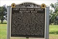
|  Fort Dodge-Camp Supply Military Road - near Bloom, KS Fort Dodge-Camp Supply Military Road - near Bloom, KS
in Wagon Roads and Trails The road passed west of this marker and ended at this marker: WMNAJ6 posted by: YoSam. location: Kansas date approved: 03/09/2015 last visited: 01/07/2016 |
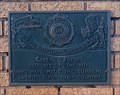
 view gallery view galleryN35.1 km | Fort Dodge-Camp Supply Military Road - US 54 in Kansas Historical Markers This Kansas historical marker is on US 54 northeast of Bloom posted by: PeterNoG location: Kansas date approved: 01/06/2008 last visited: 10/27/2021 |
 view gallery view gallery NW35.4 km NW35.4 km
|  Water Tower - Minneola KS Water Tower - Minneola KS
in Water Towers This water tower is just north of Hwy 54 and 300 yards east of Hwy 283 in Minneola, Kansas posted by: PeterNoG location: Kansas date approved: 02/14/2011 last visited: 12/27/2010 |
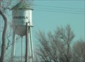 view gallery view galleryNW35.4 km | HH0906: Minneola Mun Water Tank - Minneola KS in U.S. Benchmarks This Benchmark is just north of US Hwy 54 and 300 yards east of US Hwy 283 in Minneola, Kansas posted by: PeterNoG location: Kansas date approved: 09/08/2013 last visited: 12/27/2010 |
 view gallery view galleryE39.4 km | COLDWATER (HG1043) - Coldwater, KS in U.S. Benchmarks This triangulation station is on the west edge of Coldwater, Kansas. posted by: The Snowdog location: Kansas date approved: 04/15/2024 last visited: never |
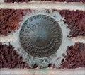 view gallery view galleryE40.2 km | HG0448 Coldwater 1934 - Coldwater, KS in U.S. Benchmarks This U.S. Coast and Geodetic Survey Disk is set in the red brick wall of the Coldwater National Bank, in Coldwater, Kansas. posted by: The Snowdog location: Kansas date approved: 01/03/2021 last visited: never |
 view gallery view gallery S40.4 km S40.4 km
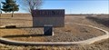
|  Buffalo Veterans Memorial - Buffalo, Oklahoma Buffalo Veterans Memorial - Buffalo, Oklahoma
in Non-Specific Veteran Memorials Veterans memorial in front of former armory in Buffalo, Oklahoma. posted by:  BruceS BruceS location: Oklahoma date approved: 04/05/2012 last visited: never |
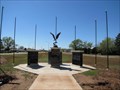
 view gallery view galleryN40.7 km | Bucklin Cemetery Veterans Memorial - Bucklin, KS in Non-Specific Veteran Memorials This modest veterans memorial is on the south side of Bucklin Cemetery - in Bucklin, Kansas. posted by: The Snowdog location: Kansas date approved: 12/30/2022 last visited: never |
 view gallery view galleryN40.7 km |  Bucklin Cemetery - Bucklin, KS Bucklin Cemetery - Bucklin, KS
in Worldwide Cemeteries Bucklin Cemetery is on the southeast side of Bucklin, Kansas. posted by: The Snowdog location: Kansas date approved: 12/28/2022 last visited: never |
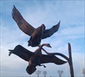 view gallery view galleryN40.7 km |  Birds In Flight - Bucklin, KS Birds In Flight - Bucklin, KS
in Figurative Public Sculpture This sculpture of two waterfowl in flight is in Bucklin Cemetery - in Bucklin, Kansas. posted by: The Snowdog location: Kansas date approved: 01/01/2023 last visited: never |
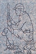 view gallery view galleryN40.7 km |  Duck Hunter - Kristofer Lars Carlson - Bucklin Cemetery, Bucklin, KS Duck Hunter - Kristofer Lars Carlson - Bucklin Cemetery, Bucklin, KS
in Occupational/Hobby Grave Stones Kristofer Lars Carlin's grave marker (and an associated sculpture) reveals his love for hunting - in Bucklin Cemetery, Bucklin, Kansas. posted by: The Snowdog location: Kansas date approved: 12/30/2022 last visited: never |
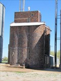 view gallery view galleryS41.5 km |  Feuquay Elevator - Buffalo, Oklahoma Feuquay Elevator - Buffalo, Oklahoma
in U.S. National Register of Historic Places Historic clay-tile grain elevator in Buffalo, Oklahoma. posted by: BruceS location: Oklahoma date approved: 04/05/2012 last visited: 03/06/2015 |
 view gallery view galleryS41.5 km | Feuquay Elevator - Buffalo, Oklahoma in Grain Elevators Historic clay-tile grain elevator in Buffalo, Oklahoma. posted by: BruceS location: Oklahoma date approved: 04/06/2012 last visited: 03/06/2015 |
 view gallery view galleryS41.5 km | Farmers' Co-op Elevator - Buffalo, Oklahoma in Grain Elevators Historic clay tile grain elevator in Buffalo, Oklahoma. posted by: BruceS location: Oklahoma date approved: 04/06/2012 last visited: 03/06/2015 |
|