 view gallery view gallery N0.2 km N0.2 km
|   Fort Eustis, VA Fort Eustis, VA
in Military Installations A 9000-acre training facility, Fort Eustis is the home of the US Army Transportation Corps. posted by:  Team Roberson Team Roberson location: Virginia date approved: 09/10/2005 last visited: 11/14/2016 |
 view gallery view galleryN0.2 km |  Fort Eustis Fort Eustis
in Wikipedia Entries A 9000-acre training facility, Fort Eustis is the home of the US Army Transportation Corps. posted by: Team Roberson location: Virginia date approved: 08/12/2008 last visited: 08/31/2014 |
 view gallery view gallery S0.8 km S0.8 km
|  Fort Eustis, VA 23604 Fort Eustis, VA 23604
in U.S. Post Offices Located at: 1321 LEE BLVD, FORT EUSTIS, VA 23604-9998 posted by: DiverVan location: Virginia date approved: 09/02/2010 last visited: 08/31/2014 |
 view gallery view gallery E1 km E1 km
|  Battle of Lee’s Mill-Flames Appeared on all Sides - Newport News VA Battle of Lee’s Mill-Flames Appeared on all Sides - Newport News VA
in U.S. Civil War Sites Brig. Gen. William F. “Baldy” Smith, found its progress slowed first by torrents of rain that made the roads almost impassable and then by Brig. Gen. Lafayette McLaws’ 1,800 Confederate troops with three guns at Lee’s Mill. posted by:  Don.Morfe Don.Morfe location: Virginia date approved: 06/26/2023 last visited: 06/26/2023 |
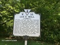 view gallery view galleryE1 km |  Lee’s Mill Lee’s Mill
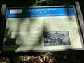
in Virginia Historical Markers Lee’s Mill, a pre-war tide mill, formed part of Confederate Maj. Gen. John Bankhead Magruder’s second Peninsula defensive line. posted by: Don.Morfe location: Virginia date approved: 03/16/2020 last visited: 09/24/2021 |
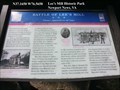
 view gallery view galleryE1 km |  Skirmish at Lee's Mill - Newport News VA Skirmish at Lee's Mill - Newport News VA
in Battlefields When Union Gen. George B. McClellan began his Peninsula Campaign, his advance against Richmond was blocked here on 5 April 1862. Brig. Gen. William F. Smith skirmished with Confederates commanded by Brig. Gen. Lafayette McLaws at Lee’s Mill. posted by: Don.Morfe location: Virginia date approved: 11/21/2020 last visited: 09/24/2021 |
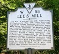 view gallery view galleryE1 km | Lee’s Mill - Newport News VA in American Civil War Monuments and Memorials Marker Location: 180 Rivers Ridge Circle, Newport News VA 23608. Marker Number: W-58 posted by: Don.Morfe location: Virginia date approved: 08/23/2023 last visited: 08/24/2023 |
 view gallery view galleryE1 km | Fortification Design-1862 Peninsula Campaign - Newport News VA in U.S. Civil War Sites The Confederate field fortifications constructed on the Virginia Peninsula were influenced by seventeenth-century French military engineer Marshal Sebastien le Prestre de Vauban and nineteenth-century American engineering professor Dennis Hart Mahan. posted by: Don.Morfe location: Virginia date approved: 06/27/2023 last visited: 06/27/2023 |
 view gallery view galleryE1 km | The Warwick-Yorktown Line - Newport News VA in Civil War Discovery Trail Sites On May 24, 1861, Confederate Col. John Magruder assumed command of the Peninsula’s defenses. He fortified points along the James and York rivers to block any Union advance toward Richmond posted by: Don.Morfe location: Virginia date approved: 07/23/2020 last visited: 09/24/2021 |
 view gallery view galleryE1 km | The Warwick-Yorktown Line 1862 - Newport News VA in U.S. Civil War Sites On May 24, 1861, Confederate Col. John Magruder assumed command of the Peninsula’s defenses. The Confederate capital at Richmond was only 80 miles from Fort Monroe, and “Prince John” Magruder did not have enough artillery or men to capture the Union. posted by: Don.Morfe location: Virginia date approved: 06/27/2023 last visited: 06/27/2023 |
 view gallery view galleryE1.1 km | The Warwick River - Newport News VA in Civil War Discovery Trail Sites Overlooking one of the James River’s tributaries, Lee’s Mill is a watershed property with a long history of settlement. The Native Americans of the Powhatan Confederation hunted and fished along the banks of the Warwick River. posted by: Don.Morfe location: Virginia date approved: 07/23/2020 last visited: 10/05/2021 |
 view gallery view galleryE1.1 km | The Warwick River - Newport News VA in U.S. Civil War Sites Overlooking one of the James River’s tributaries, Lee’s Mill is a watershed property with a long history of settlement. The Native Americans of the Powhatan Confederation hunted and fished along the banks of the Warwick River. posted by: Don.Morfe location: Virginia date approved: 06/27/2023 last visited: 06/27/2023 |
 view gallery view gallery NE1.1 km NE1.1 km
| Lee’s Mill Earthworks - Newport News VA in American Civil War Monuments and Memorials Marker Location: Warwick Blvd. (U.S. 60), Newport News VA. Marker Number: W-71 posted by: Don.Morfe location: Virginia date approved: 08/24/2023 last visited: 08/24/2023 |
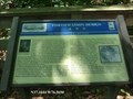
 view gallery view galleryNE1.1 km | Lee’s Mill Earthworks in Virginia Historical Markers These earthworks were part of General John B. Magruder’s second line of defense. At this site on April 5, 1862, Confederate General Lafayette McLaw’s four companies of the Tenth Georgia. posted by: Don.Morfe location: Virginia date approved: 03/16/2020 last visited: 09/24/2021 |
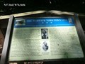
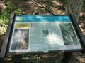
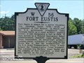 view gallery view galleryNE1.3 km | Fort Eustis in Virginia Historical Markers Fort Eustis is named for a native Virginian, Gen. Abraham Eustis (1786 – 1843), a commander of Fort Monroe. posted by: Don.Morfe location: Virginia date approved: 03/16/2020 last visited: 09/24/2021 |
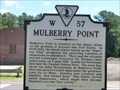 view gallery view galleryNE1.3 km | Mulberry Point in Virginia Historical Markers Mulberry Point is situated on the James River, on the grounds of present-day Fort Eustis. posted by: Don.Morfe location: Virginia date approved: 03/16/2020 last visited: 09/24/2021 |
 view gallery view galleryN1.4 km | Skirmish at Skiffes Creek - Newport News VA in Battlefields The Mulberry Island and Skiffes Creek fortifications were abandoned on May 3, 1862, when the Confederate army began its retreat towards Richmond. posted by: Don.Morfe location: Virginia date approved: 11/21/2020 last visited: 09/24/2021 |
 view gallery view galleryN1.4 km |  Stanley Hundred A New Settlement - Newport News VA Stanley Hundred A New Settlement - Newport News VA
in Signs of History Yeardley gave the new settlement he established here the name Stanley Hundred in honor of his wife’s family. The term “hundred” was an English feudal term for a division of land supporting 100 persons, usually 100 acres. posted by: Don.Morfe location: Virginia date approved: 11/13/2020 last visited: 09/24/2021 |
 view gallery view galleryN1.4 km | Balthrope-Boldrup - Newport News VA in Signs of History In 1626, William Claiborne patented 500 acres along the Warwick River above Denbign. Captain Samuel Stevens acquired the estate, called Balthrope or Boldrup, in 1631. posted by: Don.Morfe location: Virginia date approved: 11/13/2020 last visited: 09/24/2021 |
 view gallery view galleryN1.4 km | Skiffes Creek-The Defense of Mulberry Island - Newport News VA in U.S. Civil War Sites The redoubt before you is one of five earthworks built by the Confederates to help defend the Mulberry Island/James River flank of Maj. Gen. John Bankhead Magruder’s 2nd Peninsula Defensive Line. posted by: Don.Morfe location: Virginia date approved: 06/27/2023 last visited: 06/27/2023 |
 view gallery view gallery SE1.9 km SE1.9 km
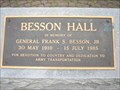
|  General Frank S. Besson Jr. General Frank S. Besson Jr.
in Specific Veteran Memorials Bronze plaque dedicated to General Frank S. Besson Jr. posted by: walkermetalsmith location: Virginia date approved: 05/01/2011 last visited: 08/31/2014 |
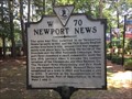 view gallery view galleryNE2.7 km | Newport News in Virginia Historical Markers Historic marker describing the founding of Newport News posted by: stinger503 location: Virginia date approved: 08/08/2017 last visited: never |
 view gallery view galleryNE2.9 km |  Newport News Park Disc Golf Course Newport News Park Disc Golf Course
in Disc Golf Courses An 18-hole championship disc golf course is located in the Arboretum area of Newport News Park. Course passes and rental discs are available at the Campsite Office. posted by: Team Roberson location: Virginia date approved: 01/02/2006 last visited: 08/30/2014 |
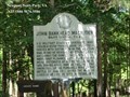 view gallery view galleryNE3.1 km | John Bankhead Magruder Major General, C S A in Virginia Historical Markers U.S. Military Academy graduate, 1830, Virginia-born 'Prince John' Magruder served with distinction in the Mexican War. posted by: Don.Morfe location: Virginia date approved: 03/16/2020 last visited: 09/24/2021 |
 view gallery view galleryN3.1 km | Lee Hall Station, VA 23603 in U.S. Post Offices Located at: 17415 WARWICK BLVD, NEWPORT NEWS, VA 23603-9998 posted by: DiverVan location: Virginia date approved: 09/02/2010 last visited: 10/17/2022 |
|