 view gallery view gallery NW0 km NW0 km
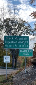
|   The Highest Point in Kentucky The Highest Point in Kentucky
in Geographic High Points Black Mountain, at an elevation of 4,145 ft, is the highest natural point in the U.S. state of Kentucky. posted by:  12IrishGlaciers 12IrishGlaciers location: Kentucky date approved: 07/10/2016 last visited: 07/17/2023 |
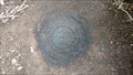
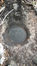
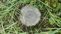 view gallery view galleryNW0 km |  U.S. Coast & Geodetic Survey Marker Disk ~ RADAR ~ Harlan County, KY U.S. Coast & Geodetic Survey Marker Disk ~ RADAR ~ Harlan County, KY
in U.S. Benchmarks A 1963 U.S. Coast & Geodetic Survey Marker Disk. posted by:  Manville Possum Manville Possum location: Kentucky date approved: 09/13/2016 last visited: 12/30/2019 |
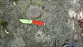 view gallery view gallery N0 km N0 km
| U.S. Coast & Geodetic Survey Bench Mark Disk ~ P 329 ~ Harlan County, KY in U.S. Benchmarks A 1953 U.S. Coast & Geodetic Survey Disk. posted by: Manville Possum location: Kentucky date approved: 09/14/2016 last visited: 07/17/2023 |
 view gallery view gallery E2.1 km E2.1 km
|  Black Mountain ~ Lynch, Kentucky ~ Elevation 4,145 ft. Black Mountain ~ Lynch, Kentucky ~ Elevation 4,145 ft.
in Elevation Signs Black Mountain is the highest mountain peak in the Commonwealth of Kentucky with a summit elevation of 4,145 feet above sea level. posted by: Manville Possum location: Kentucky date approved: 10/26/2021 last visited: 10/26/2021 |
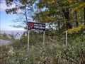 view gallery view galleryE2.1 km |  Welcome to Virginia - Virginia is for Lovers - Appalachia, Virginia Welcome to Virginia - Virginia is for Lovers - Appalachia, Virginia
in Welcome Signs A Virginia Welcome sign on top of Black Mountain at the Kentucky state line. posted by: Manville Possum location: Virginia date approved: 10/27/2021 last visited: 10/27/2021 |
 view gallery view gallery W2.3 km W2.3 km
| US Benchmark W 327 ~ PID - GA1328 ~ Harlan County, Kentucky in U.S. Benchmarks US Benchmark W 327 ~ PID - GA1328 ~ Harlan County, Kentucky posted by: Manville Possum location: Kentucky date approved: 05/26/2017 last visited: 12/30/2019 |
 view gallery view galleryW3.5 km |  Garrison Family Cemetery ~ Black Mountain, Kentucky Garrison Family Cemetery ~ Black Mountain, Kentucky
in Homemade Tombstones A small family cemetery on Black Mountain Ridge road. posted by: Manville Possum location: Kentucky date approved: 11/14/2016 last visited: 12/30/2019 |
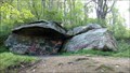 view gallery view galleryW3.9 km |  The John Garrison Rock House on Black Mountain The John Garrison Rock House on Black Mountain
in Remains of Settlements Harlan’s County’s Big Black Mountain, whose elevation is a towering 4,145 feet, is home of Kentucky’s highest point. Big Black Mountain is a historic and grand coal mining mountain. Long before the mountain was exploited for it’s rich coal deposits, many settlers in the early days of Harlan County called the slopes of this vast mountain their home. posted by: Manville Possum location: Kentucky date approved: 05/21/2017 last visited: 05/23/2017 |
 view gallery view galleryW4.3 km | US Benchmark B 328 ~ PID - GA1326 ~ Harlan County, Kentucky in U.S. Benchmarks US Benchmark B 328 ~ PID - GA1326 ~ Harlan County, Kentucky posted by: Manville Possum location: Kentucky date approved: 05/24/2017 last visited: 12/30/2019 |
 view gallery view galleryN6 km |  1919 - The United Supply Co. Incorporated - Lynch, KY USA 1919 - The United Supply Co. Incorporated - Lynch, KY USA
in Dated Buildings and Cornerstones Lynch KY was a coal-mining company town, named for Thomas Lynch, then head of US Coal & Coke Company. This building, built in 1919, used to house the Company Commissary posted by: Benchmark Blasterz location: Kentucky date approved: 03/23/2022 last visited: 03/24/2022 |
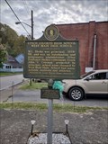
 view gallery view galleryN6 km |  Lynch ~ Lynch, Kentucky. Lynch ~ Lynch, Kentucky.
in Kentucky Historical Markers Historical Marker #1803 in Harlan County commemorates Lynch, the largest company-owned town in Kentucky through World War II. posted by: Manville Possum location: Kentucky date approved: 10/24/2021 last visited: 10/24/2021 |
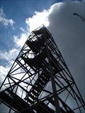
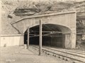
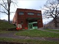
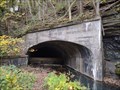 view gallery view galleryN6 km |  Lynch Mine Portal No. 30 - 1920 - Lynch, Kentucky - USA Lynch Mine Portal No. 30 - 1920 - Lynch, Kentucky - USA
in Dated Architectural Structures Multifarious A abandoned historic 1920 underground coal mine portal number 30 in Lynch, Kentucky. posted by: Manville Possum location: Kentucky date approved: 10/25/2021 last visited: 10/25/2021 |
 view gallery view galleryN6 km |  Lynch Mine No. 30 ~ Lynch, Kentucky Lynch Mine No. 30 ~ Lynch, Kentucky
in Photos Then and Now A then and now photo of the 1920 mine portal No. 30 in Lynch, Kentucky. posted by: Manville Possum location: Kentucky date approved: 10/25/2021 last visited: 11/10/2021 |
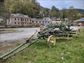 view gallery view galleryN6.1 km |  Adams Leaning Wheel Grader No. 10 ~ Lynch, Kentucky. Adams Leaning Wheel Grader No. 10 ~ Lynch, Kentucky.
in Preserved Machines on Public Display A Adams Leaning Wheel Grader No. 10 horse drawn road grader on public display in Lynch, Kentucky. posted by: Manville Possum location: Kentucky date approved: 11/06/2021 last visited: 11/06/2021 |
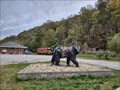 view gallery view galleryN6.1 km |  Coal Miner Bear ~ Lynch, Kentucky. Coal Miner Bear ~ Lynch, Kentucky.
in Bear Statues A artistically painted fiberglass bear statue depicting coal mining history in Lynch, Kentucky. posted by: Manville Possum location: Kentucky date approved: 10/25/2021 last visited: 10/25/2021 |
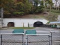 view gallery view galleryN6.1 km |  Tourism ~ Portal 31 Exhibit Mine ~ Lynch, Kentucky - USA. Tourism ~ Portal 31 Exhibit Mine ~ Lynch, Kentucky - USA.
in Official Local Tourism Attractions "Portal No. 31 Underground Mine Tour offers visitors the unique experience of touring an actual coal mine by rail car." posted by: Manville Possum location: Kentucky date approved: 10/25/2021 last visited: 10/25/2021 |
 view gallery view galleryNW6.8 km | Lynch Colored High School - West Main High School ~ Lynch, Kentucky. in Kentucky Historical Markers Historical Marker #2109 in Lynch, Kentucky (Harlan County) commemorates the history of the Lynch Colored School, a segregation-era school that educated the community’s African American students. posted by: Manville Possum location: Kentucky date approved: 10/24/2021 last visited: 10/24/2021 |
 view gallery view galleryW7.1 km | US Benchmark D 328 ~ PID - GA1322 ~ Harlan County, Kentucky in U.S. Benchmarks US Benchmark D 328 ~ PID - GA1322 ~ Harlan County, Kentucky posted by: Manville Possum location: Kentucky date approved: 05/24/2017 last visited: 12/30/2019 |
 view gallery view gallery S7.2 km S7.2 km
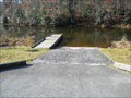
|  Lake Keokee Recreation Area, VA Lake Keokee Recreation Area, VA
in Boat Ramps Boat launch for Lake Keokee. No gasoline motors are allowed on the 92-acre lake. posted by: vhasler location: Virginia date approved: 12/02/2012 last visited: never |
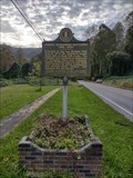 view gallery view galleryNW7.2 km | JOSEPH ALEXANDER MATTHEWS (1902-1970) ~ Lynch, Kentucky. in Kentucky Historical Markers A Kentucky historical marker about Joseph Alexander Matthews. posted by: Manville Possum location: Kentucky date approved: 10/24/2021 last visited: 10/24/2021 |
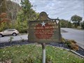 view gallery view galleryNW7.6 km |  KY 160 ~ Benham, Kentucky KY 160 ~ Benham, Kentucky
in Blue Star Memorial Highway Markers A Blue Star Memorial Highway marker in Benham, Kentucky along highway 160. posted by: Manville Possum location: Kentucky date approved: 10/25/2021 last visited: 10/25/2021 |
 view gallery view galleryNW7.6 km |  Benham Lodge #880 ~ Benham, Kentucky. Benham Lodge #880 ~ Benham, Kentucky.
in Masonic Temples Masonic lodge in Benham, Kentucky. posted by: Manville Possum location: Kentucky date approved: 11/08/2021 last visited: 11/08/2021 |
 view gallery view galleryNW7.6 km |  Benham Theater, Benham, KY Benham Theater, Benham, KY
in Vintage Movie Theaters Vintage theater in the coal country of Eastern Kentucky. posted by: Wallyum location: Kentucky date approved: 06/09/2022 last visited: never |
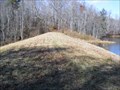 view gallery view galleryS8 km |  Lake Keokee dam - Appalachia, VA Lake Keokee dam - Appalachia, VA
in Water Dams Earthen dam for 92-acre lake in state recreation area. posted by: vhasler location: Virginia date approved: 12/16/2012 last visited: never |
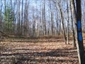 view gallery view galleryS8.9 km |  Olinger Gap - VA Olinger Gap - VA
in Named Mountain Gaps Olinger Gap allowed passage through Stone Mountain. posted by: vhasler location: Virginia date approved: 12/14/2012 last visited: never |
|