 view gallery view gallery W2.1 km W2.1 km
|   Mike's BAR-B-CUE - Guthrie, KY Mike's BAR-B-CUE - Guthrie, KY
in Classic BBQ and Sandwich Joints Mike is using the receipe from his mother made when he was growing up. Mike developed his BBQ skills cooking for church get togethers and then opened his joint in 2002 posted by:  nomadwillie nomadwillie location: Kentucky date approved: 03/16/2013 last visited: never |
 view gallery view galleryW2.1 km | Red Top Barbecue - Guthrie, KY in Classic BBQ and Sandwich Joints The joint is located in a brand new log cabin with a red roof. Log cabin and BBQ just seem to go together posted by: nomadwillie location: Kentucky date approved: 03/16/2013 last visited: never |
 view gallery view galleryW2.7 km |  Humongous Heifer Humongous Heifer
in Ginormous Everyday Objects One darn big Cow. posted by: Airmapper location: Kentucky date approved: 02/12/2006 last visited: 08/22/2010 |
 view gallery view gallery SW8.4 km SW8.4 km
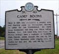
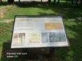
|  Camp Boone Camp Boone
in Tennessee Historical Markers Staging area and training camp for Kentuckians wanting to join the CSA. posted by: snfromky location: Tennessee date approved: 08/20/2006 last visited: 07/31/2016 |
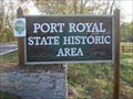 view gallery view gallery S10.8 km S10.8 km
|  Port Royal State Park - Adams, Tennessee Port Royal State Park - Adams, Tennessee
in State/Provincial Parks A small park with historical significance. posted by: snfromky location: Tennessee date approved: 11/11/2007 last visited: 07/31/2016 |
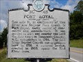
 view gallery view galleryS10.8 km |  The Town of Port Royal - Adams TN The Town of Port Royal - Adams TN
in Signs of History Port Royal was one of the earliest towns in Tennessee. It began as a settlers fort around 1785 and was founded as a town in 1797, one year after Tennessee became a state. posted by:  Don.Morfe Don.Morfe location: Tennessee date approved: 10/19/2020 last visited: 09/25/2021 |
 view gallery view galleryS10.8 km | 1859 Masonic Lodge & General Store - Adams TN in Signs of History This building served as a lodge, general store, and post office from 1859 until the 1950s. Today it serves as the Port Royal State Park Headquarters. posted by: Don.Morfe location: Tennessee date approved: 10/19/2020 last visited: 09/25/2021 |
 view gallery view galleryS10.8 km |  Sulphur Fork Bridge-Port Royal State Park, TN Sulphur Fork Bridge-Port Royal State Park, TN
in Orphaned Bridges Located in the Port Royal State Park, a bridge used to carry the Clarksville to Springfield highway now carries only foot traffic. posted by: snfromky location: Tennessee date approved: 11/04/2007 last visited: 07/31/2016 |
 view gallery view galleryS10.8 km | Stores of Port Royal - Adams TN in Signs of History The earliest stores in Port Royal date back to the late 1790s, most of which were taverns and inns. Stores could thrive for many years due to the commerce brought in by the Great Western Road which passed through Port Royal. posted by: Don.Morfe location: Tennessee date approved: 10/19/2020 last visited: 09/25/2021 |
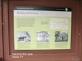
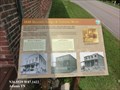
 view gallery view galleryS10.8 km |  Port Royal State Historic Area-Adams, TN Port Royal State Historic Area-Adams, TN
in Trail of Tears A way-stop along the Trail of Tears. posted by: snfromky location: Tennessee date approved: 11/12/2007 last visited: 07/31/2016 |
 view gallery view gallerySW11.1 km |  Beachaven Vinyards and Winery Beachaven Vinyards and Winery
in Wineries Located in Clarksville, Tennessee, about 40 miles northwest of Nashville
on I-24, Beachaven Vinyards and Winery has won many awards. posted by: snfromky location: Tennessee date approved: 11/04/2007 last visited: 05/26/2012 |
 view gallery view gallery SE11.7 km SE11.7 km
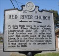
| Red River Church in Tennessee Historical Markers This sign commemorates the first church west of the Cumberlands. posted by: snfromky location: Tennessee date approved: 11/03/2007 last visited: 06/13/2008 |
 view gallery view gallerySW12.1 km |  Childs Family Cemetery Childs Family Cemetery
in Worldwide Cemeteries A small family plot, official sign dates it at 1858. posted by: O-Mega location: Tennessee date approved: 12/19/2006 last visited: 05/26/2012 |
 view gallery view gallerySW12.1 km | JOHNSON-KILLEBREW CEMETERY in Worldwide Cemeteries A small well kept family cemetery located on Fair Brook Place by Wal-Mart, Logan's Roadhouse, and McDonalds off of Wilma Rudolph Blvd, in Clarksville, TN. posted by: O-Mega location: Tennessee date approved: 12/19/2006 last visited: 05/26/2012 |
 view gallery view gallery NE12.1 km NE12.1 km
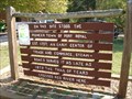
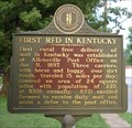
|  First RFD in Kentucky, Allensville, KY First RFD in Kentucky, Allensville, KY
in First of its Kind The first RFD route in Kentucky. posted by: snfromky location: Kentucky date approved: 07/19/2008 last visited: 07/18/2008 |
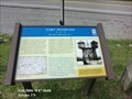
 view gallery view galleryNE12.1 km |  First RFD in Kentucky First RFD in Kentucky
in Kentucky Historical Markers Farmers finally get their mail delivered. posted by: snfromky location: Kentucky date approved: 07/20/2008 last visited: 07/18/2008 |
 view gallery view gallerySW12.1 km |  White Castle - Wilma Rudolph Blvd - Clarksville, TN White Castle - Wilma Rudolph Blvd - Clarksville, TN
in White Castle A fast meal can be found here, and then back on the road. posted by: 8Nuts MotherGoose location: Tennessee date approved: 06/13/2008 last visited: 05/27/2012 |
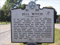 view gallery view gallerySE12.4 km | Bell Witch - 3 C 38 in Tennessee Historical Markers Tennessee Historical Commission marker 3 C 38 - Bell Witch posted by: LSUMonica location: Tennessee date approved: 03/13/2006 last visited: 08/01/2008 |
 view gallery view gallerySE12.4 km |  Fort Redmond-Red River Blockhouse No. 1 - Adams, TN Fort Redmond-Red River Blockhouse No. 1 - Adams, TN
in Civil War Discovery Trail Sites Confederate forces constructed Fort Redmond to protect and defend the railroad bridge a mile northwest of here, near the confluence of the Red River and the Elk Fork Creek. posted by: Don.Morfe location: Tennessee date approved: 03/10/2020 last visited: 10/08/2021 |
 view gallery view gallerySE12.4 km | Fort Redmond Red River Blockhouse No. 1 - Adams TN in U.S. Civil War Sites Confederate forces constructed Fort Redmond to protect and defend the railroad bridge a mile northwest of here, near the confluence of the Red River and the Elk Fork Creek. posted by: Don.Morfe location: Tennessee date approved: 04/29/2023 last visited: 04/30/2023 |
 view gallery view galleryS12.4 km | Port Royal 3C 45 - Adams, TN in Tennessee Historical Markers One of apparently two signs of the same topic. Port Royal 3C 45 Tennessee historical marker is located along TN-76 highway were TN-238 conjoins with TN-76. posted by: WayBetterFinder location: Tennessee date approved: 06/09/2019 last visited: 06/09/2019 |
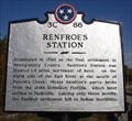 view gallery view galleryS12.7 km | Renfroe's Station in Tennessee Historical Markers Site of the first settlement in Montgomery County, TN. posted by: snfromky location: Tennessee date approved: 11/03/2007 last visited: 07/31/2016 |
 view gallery view galleryW13.2 km |  Yong In Martial Arts - Clarksville, TN Yong In Martial Arts - Clarksville, TN
in Martial Arts Tae Kwon Do; Hap Ki Do; Judo; Kum Do posted by: YoSam. location: Tennessee date approved: 10/23/2016 last visited: never |
 view gallery view galleryW13.2 km |  Dos Margaritas Mexican Grill - Clarksville, TN Dos Margaritas Mexican Grill - Clarksville, TN
in Mexican Restaurants Popular name in the south posted by: YoSam. location: Tennessee date approved: 10/23/2016 last visited: never |
 view gallery view galleryW14.6 km |  I-24 Welcome Center - Clarksville, TN I-24 Welcome Center - Clarksville, TN
in Tourist Information Centers - Visitor Centers Eastbound and down, the first one you come to in Tennessee - mail marker 0.40 posted by: YoSam. location: Tennessee date approved: 07/20/2019 last visited: never |
|