 view gallery view gallery SE3.5 km SE3.5 km
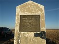
|   Santa Fe Trail – Cimarron Cutoff – Grenville, New Mexico Santa Fe Trail – Cimarron Cutoff – Grenville, New Mexico
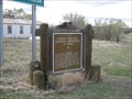
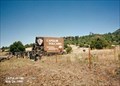
in Wagon Roads and Trails This roadside marker located just South and East of the town of Grenville, New Mexico, marks the first use of wagons on the Santa-Fe trail. The use of wagons instead of pack animals dramatically expanded migration and trade in the region. posted by:  PersonsMD PersonsMD location: New Mexico date approved: 01/08/2013 last visited: 12/08/2012 |
 view gallery view gallery NW20.1 km NW20.1 km
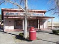
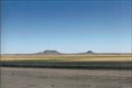
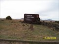
|  Hwy. 85/64 Rest Area - Union County, New Mexico Hwy. 85/64 Rest Area - Union County, New Mexico
in Highway Rest Areas Located Between Clayton and Raton. posted by: mr.volkswagen location: New Mexico date approved: 12/23/2008 last visited: 07/23/2007 |
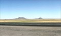
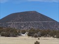
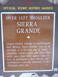 view gallery view galleryNW20.1 km |  Sierra Grande Sierra Grande
in New Mexico Historical Markers Located on Hwy. 85/64 between Clayton and Raton posted by: mr.volkswagen location: New Mexico date approved: 12/23/2008 last visited: 07/23/2007 |
 view gallery view gallery E28.8 km E28.8 km
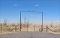
|  Grandview Cemetery - Clayton, NM Grandview Cemetery - Clayton, NM
in Worldwide Cemeteries A small desert cemetery in Union County, New Mexico posted by: The Snowdog location: New Mexico date approved: 07/09/2020 last visited: never |
 view gallery view gallerySE30.7 km | Otto Cemetery - Clayton, NM in Worldwide Cemeteries Otto Cemetery is all that remains of the ghost town of Otto, New Mexico. posted by: The Snowdog location: New Mexico date approved: 04/06/2023 last visited: never |
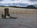
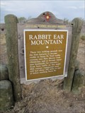
 view gallery view galleryE32.5 km |  Rabbit Ears (Clayton Complex) ~ Clayton, NM Rabbit Ears (Clayton Complex) ~ Clayton, NM
in U.S. National Register of Historic Places Named after and old Indian Chief, and a famous landmark on the Santa Fe Trail. posted by: YoSam. location: New Mexico date approved: 07/13/2009 last visited: 05/06/2012 |
 view gallery view galleryE32.5 km |  Rabbit Ears - Clayton, New Mexico Rabbit Ears - Clayton, New Mexico
in Wikipedia Entries Used as a guide post for both the early Spanish and the Santa Fe merchants. posted by: YoSam. location: New Mexico date approved: 08/06/2016 last visited: never |
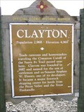 view gallery view galleryE35.7 km | Clayton in New Mexico Historical Markers West of town and invitin' you in. posted by: YoSam. location: New Mexico date approved: 07/07/2009 last visited: 04/06/2023 |
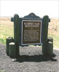 view gallery view galleryE35.7 km | Rabbit Ear Mountain in New Mexico Historical Markers First landmark to aid travel since leaving Oklahoma on the Santa Fe Trail. posted by: YoSam. location: New Mexico date approved: 07/07/2009 last visited: 10/30/2021 |
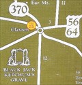 view gallery view galleryE35.7 km |  Points of Interest ~ Clayton, NM Points of Interest ~ Clayton, NM
in 'You Are Here' Maps Rabbit Ear Mountains, a Santa Fe Trail landmark. posted by: YoSam. location: New Mexico date approved: 07/08/2009 last visited: 04/06/2023 |
 view gallery view galleryE35.7 km |  Clayton, New Mexico - Population: 2,968 Clayton, New Mexico - Population: 2,968
in Population Signs Western city limits of Clayton posted by: YoSam. location: New Mexico date approved: 08/07/2016 last visited: 04/06/2023 |
 view gallery view galleryE35.7 km |  Clayton New Mexico - 4,969 feet Clayton New Mexico - 4,969 feet
in Elevation Signs West of town and invitin' you in. posted by: YoSam. location: New Mexico date approved: 08/06/2016 last visited: 04/06/2023 |
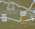 view gallery view galleryNW38 km | You Are at Capulin Volcano, New Mexico in 'You Are Here' Maps Capulin Volcano can be seen in the distance from this sign that indicates you are at the volcano. posted by: Queens Blessing location: New Mexico date approved: 06/13/2010 last visited: 07/23/2007 |
 view gallery view galleryNW38 km | Capulin Volcano National Monument in New Mexico Historical Markers There are several of these signs along the route to Capulin Volcano. posted by: Queens Blessing location: New Mexico date approved: 06/14/2010 last visited: 07/23/2007 |
 view gallery view gallerySE38.5 km | Rabbit Ear Mountain in New Mexico Historical Markers Marker for historic landmark located along US Hwy 56/412 southwest of Clayton, New Mexico. posted by:  BruceS BruceS location: New Mexico date approved: 04/14/2012 last visited: never |
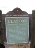 view gallery view gallerySE38.5 km | Clayton in New Mexico Historical Markers Marker giving brief history of Clayton, New Mexico. posted by: BruceS location: New Mexico date approved: 04/14/2012 last visited: never |
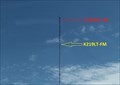 view gallery view galleryE39.4 km |  K219LT-FM 91.7 (KBKN) & K228DP-FM 93.5 (KENW) -- Clayton NM USA K219LT-FM 91.7 (KBKN) & K228DP-FM 93.5 (KENW) -- Clayton NM USA
in Radio and Television Transmitter Towers Two low-power FM translators broadcast distant stations to listeners in Clayton NM from this tower along the US64/87 just outside the city limit of Clayton NM posted by: Benchmark Blasterz location: New Mexico date approved: 01/29/2023 last visited: 01/30/2023 |
 view gallery view galleryNW39.4 km | Capulin Volcano National Monument, New Mexico in New Mexico Historical Markers This sign is located at the intersection of highways 87 & 325 in the tiny town of Capulin, New Mexico. posted by: Queens Blessing location: New Mexico date approved: 06/13/2010 last visited: 07/23/2007 |
 view gallery view galleryNW39.8 km | ") Capulin Volcano National Monument Capulin Volcano National Monument
in National Parks (U.S.) Capulin Volcano National Monument, located in Northeastern New Mexico, was designated a U.S. National Monument on August 9, 1916. posted by: Web-ling location: New Mexico date approved: 10/30/2006 last visited: 01/15/2023 |
 view gallery view galleryNW39.8 km |  Capulin Volcano Capulin Volcano
in Mountain Summits An extinct volcano in NE New Mexico posted by: Web-ling location: New Mexico date approved: 10/30/2006 last visited: 01/15/2023 |
 view gallery view galleryNW39.8 km |  Capulin Volcano National Monument - Capulin NM Capulin Volcano National Monument - Capulin NM
in National Parks of the World Capulin Volcano National Monument is a U.S. National Monument located in northeastern New Mexico that protects and interprets an extinct cinder cone volcano and is part of the Raton-Clayton volcanic field. posted by:  Don.Morfe Don.Morfe location: New Mexico date approved: 01/15/2023 last visited: 01/15/2023 |
 view gallery view galleryNW39.8 km |  Capulin Volcano National Monument - Capulin NM Capulin Volcano National Monument - Capulin NM
in Official Local Tourism Attractions Capulin Volcano National Monument is an example of an extinct cinder cone volcano, & part of the Raton-Clayton Volcanic Field. A paved road spirals around the volcano and visitors can drive up to a parking lot at the rim. posted by: Don.Morfe location: New Mexico date approved: 01/14/2023 last visited: 01/15/2023 |
 view gallery view galleryNW39.8 km |  Ranger Station at Capulin Volcano National Monument - Capulin NM Ranger Station at Capulin Volcano National Monument - Capulin NM
in Ranger Stations The Ranger Station is inside the Visitor Center at Capulin Volcano National Monument. Here one may obtain a NPS Cancellation Stamp. posted by: Don.Morfe location: New Mexico date approved: 01/17/2023 last visited: 01/15/2023 |
 view gallery view galleryNW39.8 km |  Capulin Volcano National Monument - Capulin NM Capulin Volcano National Monument - Capulin NM
in Satellite Imagery Oddities Capulin Volcano National Monument is an example of an extinct cinder cone volcano, & part of the Raton-Clayton Volcanic Field. A paved road spirals around the volcano and visitors can drive up to a parking lot at the rim. posted by: Don.Morfe location: New Mexico date approved: 01/14/2023 last visited: 01/15/2023 |
 view gallery view galleryNW39.8 km | Capulin Volcano National Monument in Wikipedia Entries Capulin Volcano erupted into existence sometime between 56,000 and 62,000 years ago. posted by: mr.volkswagen location: New Mexico date approved: 01/11/2009 last visited: 01/15/2023 |
|