 view gallery view gallery NW17.4 km NW17.4 km
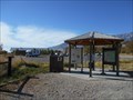
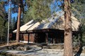
|   Eastern Sierra Visitor Center, Inyo N. F. - Long Pine CA Eastern Sierra Visitor Center, Inyo N. F. - Long Pine CA
in Tourist Information Centers - Visitor Centers Thirteen of the peaks over 14,000 feet are in Inyo County. Permits are required for Wilderness access and trails.
There is a picnic area, bookstore and gift shop, area maps. posted by:  sbcamper sbcamper location: California date approved: 08/14/2022 last visited: never |
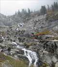 view gallery view galleryNW18.7 km |  Tokopah Falls - Sequoia National Park, CA Tokopah Falls - Sequoia National Park, CA
in Waterfalls The Tokopah Falls is located at the end of the 1.7 mile Tokopah Valley Trail, which begins at the Lodgepole Campground in Sequoia National Park, CA. posted by:  Merlin-N-Mim Merlin-N-Mim location: California date approved: 10/25/2009 last visited: 06/14/2014 |
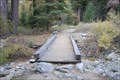 view gallery view galleryNW19.3 km |  Tokopah Valley Trail Bridge - Sequoia National Park, California Tokopah Valley Trail Bridge - Sequoia National Park, California
in Hiking Path Footbridges This is a beautiful moderate 1.7 mile hiking trail to Tokopah Falls. The bridge crosses a small stream that cuts the trail. posted by: teeoff2 location: California date approved: 11/06/2008 last visited: 11/07/2010 |
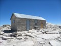 view gallery view gallery E19.5 km E19.5 km
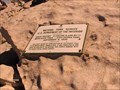
|  Smithsonian Institution Shelter - Mt. Whitney, CA Smithsonian Institution Shelter - Mt. Whitney, CA
in U.S. National Register of Historic Places Mt. Whitney Smithsonian Research Facility
Sequoia National Park, CA posted by: fresgo location: California date approved: 08/06/2013 last visited: 08/05/2013 |
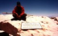 view gallery view galleryE19.5 km |  Mt. Whitney Mt. Whitney
in Mountain Summits Mt Whitney is the highest point in the contiguous United States. posted by: wilsonjw location: California date approved: 09/08/2005 last visited: 08/01/2013 |
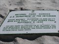 view gallery view galleryE19.5 km |  Highest Point in California (Mt Whitney) Highest Point in California (Mt Whitney)
in Geographic High Points Mt Whitney at 14,505 feet is the highest point in California, as well as the lower 48 states and both Tulare and Inyo counties. posted by: Rumpled location: California date approved: 10/20/2008 last visited: 08/04/2013 |
 view gallery view galleryE19.5 km | Highest Point in Tulare County (Mt Whitney) in Geographic High Points Mt Whitney at 14,505 feet is the highest point in Tulare County, as well as the lower 48 states, the state of California and Inyo County. posted by: Rumpled location: California date approved: 10/20/2008 last visited: 08/04/2013 |
 view gallery view galleryE19.5 km | Highest Point in Inyo County (Mt Whitney) in Geographic High Points Mt Whitney at 14,505 feet is the highest point in Inyo County, as well as the lower 48 states, the state of California and Tulare County.
posted by: Rumpled location: California date approved: 10/20/2008 last visited: 08/01/2013 |
 view gallery view gallery W20.8 km W20.8 km
|  Tokopah Valley Falls Trail - Sequoia N park - CA Tokopah Valley Falls Trail - Sequoia N park - CA
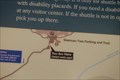
in Hiking and walking trailheads From the camp grounds. Fee to enter the National Park. Separate fees to camp, vary from tent to hook ups. This begins at a crossing of the Marble Fork Kaweah River. posted by: sbcamper location: California date approved: 07/24/2015 last visited: never |
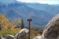 view gallery view galleryW20.9 km |  Eagle View High Sierra Trail - Sequoia National Park, California Eagle View High Sierra Trail - Sequoia National Park, California
in Scenic Overlooks The High Sierra trail is a beautiful trail that spans the Sierra mountains and runs for many miles. This view is just a mile or so from Crescent meadow in Sequoia National Park. posted by: teeoff2 location: California date approved: 11/06/2008 last visited: 11/06/2008 |
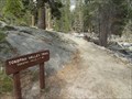
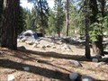 view gallery view galleryW21.2 km |  Lodgepole Campground - Sequoia National Park, CA Lodgepole Campground - Sequoia National Park, CA
in Campgrounds The Lodgepole Campground is at a 6700-foot (2042m) elevation along the Marble Fork of the Kaweah River, 2 miles (3km) from the Giant Forest sequoia grove; 21 miles from Sequoia Park entrance.
posted by: Merlin-N-Mim location: California date approved: 10/29/2009 last visited: 10/17/2008 |
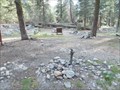
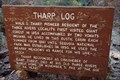 view gallery view galleryW21.2 km |  Tharp's Log - Sequoia National Park, California Tharp's Log - Sequoia National Park, California
in Treehouses A giant red wood log used as a home for Hale Tharp, the first European settler to homestead in the Sequoia Giant Forest.
This house is on a nice trail that starts at the Cresent Meadow Picnic area in Sequoia National park. posted by: teeoff2 location: California date approved: 10/30/2008 last visited: 10/18/2009 |
 view gallery view galleryW21.4 km |  Sequoia National Park - Lodgepole Market Penny Smasher Sequoia National Park - Lodgepole Market Penny Smasher
in Penny Smashers This four-design hand-cranked Penny Smasher is in the Lodgepole Market in Sequoia National Park, California. An admission fee is required to access this machine. posted by: brwhiz location: California date approved: 08/29/2012 last visited: 05/12/2015 |
 view gallery view galleryW21.4 km |  Sequoia National Park, California 93262 Sequoia National Park, California 93262
in U.S. Post Offices Located in the Lodgepole area of the park, this very nice post office is open for business. posted by: teeoff2 location: California date approved: 10/29/2008 last visited: 08/08/2018 |
 view gallery view galleryW21.4 km |  Sequoia/ Kings Canyon UNESCO Biosphere Reserve - CA Sequoia/ Kings Canyon UNESCO Biosphere Reserve - CA
in UNESCO Geoparks and Biosphere Reserves The second oldest U S National Park. It combines what were once two separate parks. Promoted by John Muir. The plaque is located near the Lodgepole Visitor Center. posted by: sbcamper location: California date approved: 07/14/2015 last visited: 08/08/2018 |
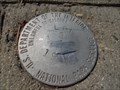 view gallery view galleryW21.4 km |  LPL 3 - Sequoia National Park, CA LPL 3 - Sequoia National Park, CA
in U.S. Benchmarks Surprised to find this one on the sidewalk near parking at the Lodgepole area. posted by: sbcamper location: California date approved: 05/12/2015 last visited: never |
 view gallery view galleryW21.4 km |  Lodgepole C G pump - Sequoia N P CA Lodgepole C G pump - Sequoia N P CA
in Hand Operated Water Pumps Found these in the tent camping area. Guess they are shut off
for the winter. They don't appear to be freeze style. posted by: sbcamper location: California date approved: 06/09/2015 last visited: never |
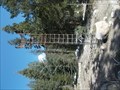 view gallery view galleryW21.6 km |  Lodgepole NPS - Sequoia Nat'l Park - CA Lodgepole NPS - Sequoia Nat'l Park - CA
in Weather Stations Non automated station. posted by: sbcamper location: California date approved: 06/11/2015 last visited: never |
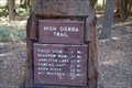 view gallery view galleryW21.7 km | High Sierra Trail, Crescent Meadow - Sequoia National Park, Ca. in Hiking and walking trailheads A 72.2 mile trail that crosses the Sierra's to Mount Whitney. posted by: teeoff2 location: California date approved: 03/06/2009 last visited: 03/06/2009 |
 view gallery view galleryW22.4 km |  General Sherman Tree - Sequoia National Park, California General Sherman Tree - Sequoia National Park, California
in 'You Are Here' Maps The short hike to the General Sherman tree starts with this You are Here sign posted by: teeoff2 location: California date approved: 11/03/2008 last visited: 08/08/2018 |
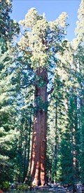 view gallery view galleryW22.5 km |  General Sherman Tree - Sequoia National Park, California, USA General Sherman Tree - Sequoia National Park, California, USA
in American Guide Series "General Sherman Tree, the largest living thing" posted by: netdust location: California date approved: 05/31/2015 last visited: 07/31/2023 |
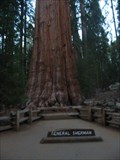
 view gallery view galleryW22.5 km |  General Sherman: World's Largest (not Tallest) Tree - Sequoia N.P., California, USA General Sherman: World's Largest (not Tallest) Tree - Sequoia N.P., California, USA
in Roadside Attractions The largest known living single stem tree on earth, named after a Civil War General. posted by: netdust location: California date approved: 05/31/2015 last visited: 01/14/2024 |
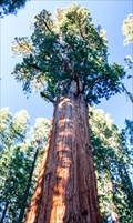
 view gallery view galleryW22.5 km |  General Sherman General Sherman
in Exceptional Trees The General Sherman Giant Sequoia is located in Sequuoia National park, California. posted by: Jagman714 location: California date approved: 12/12/2006 last visited: 07/31/2023 |
 view gallery view galleryW22.5 km | ") Sequoia National Park Sequoia National Park
in National Parks (U.S.) The world's largest trees posted by: Bernd das Brot Team location: California date approved: 05/17/2008 last visited: 07/31/2023 |
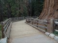 view gallery view galleryW22.5 km |  General Sherman boardwalk - Sequoia National Park CA General Sherman boardwalk - Sequoia National Park CA
in Non-Coastal Boardwalks Protecting a meadow. Part of the walkway to the giant sequoia. posted by: sbcamper location: California date approved: 05/28/2015 last visited: 07/31/2023 |
|