  SW9.8 km SW9.8 km
|   Mulberry Creek Bridge Mulberry Creek Bridge
in Pedestrian Suspension Bridges Pedestrian Bridge over Mulberry River, Johnson County, Arkansas. posted by:  [DELETED_USER] [DELETED_USER] location: Arkansas date approved: 11/05/2005 last visited: 10/24/2009 |
 view gallery view gallery S11.4 km S11.4 km
|  Wilson Douglas Watson-Ozone, AR Wilson Douglas Watson-Ozone, AR
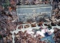
in Medal Of Honor Resting Places World War II Medal of Honor Recipient for action at Iwo Jima, Volcano Islands on February 26-27, 1945. He is buried in Russell Cemetery, Ozone, AR. posted by: Don.Morfe location: Arkansas date approved: 12/23/2017 last visited: 12/18/2021 |
 view gallery view gallerySW18.2 km |  Mulberry River - Wolf Pen to Byrd's Outdoors Mulberry River - Wolf Pen to Byrd's Outdoors
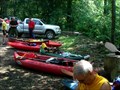
in Canoe/Kayak Trips A Class I-III scenic river. posted by: ar_kayaker location: Arkansas date approved: 07/17/2007 last visited: never |
 view gallery view gallery SE19.8 km SE19.8 km
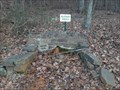
|  USFS Benchmark T12/ 1/4 S 30 29 /R 21 Haw Creek Falls Natural Area, Arkansas, U.S.A. USFS Benchmark T12/ 1/4 S 30 29 /R 21 Haw Creek Falls Natural Area, Arkansas, U.S.A.
in U.S. Benchmarks USDA benchmark in Haw Creek Falls, Arkansas posted by:  Hummingbird & Blue Jay Hummingbird & Blue Jay location: Arkansas date approved: 08/08/2014 last visited: never |
 view gallery view galleryS26.9 km |  Hudson Springs - Clarksville, AR Hudson Springs - Clarksville, AR
in Natural Springs Hudson Springs is on the west side of Highway 103 northwest of Clarksville, Arkansas. posted by: The Snowdog location: Arkansas date approved: 11/19/2020 last visited: never |
 view gallery view gallery E27.2 km E27.2 km
|  Cowell Cemetery - Cowell, Arkansas Cowell Cemetery - Cowell, Arkansas
in Worldwide Cemeteries This small country cemetery is a mile south of the ghost town of Cowell, Arkansas. posted by: The Snowdog location: Arkansas date approved: 11/13/2020 last visited: never |
 view gallery view gallery W28.3 km W28.3 km
|  Cadastral at corner of Lone Pine Cemetery Cadastral at corner of Lone Pine Cemetery
in Public Land Survey Marks U.S. Dept of the Interior Cadastral Survey - Bur. of Land Management
T12 N R 26W 1/4 S34 1993 posted by: JnEcache location: Arkansas date approved: 08/22/2012 last visited: never |
 view gallery view gallery N29.5 km N29.5 km
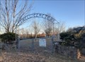
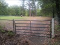
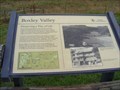
|  Boxley Valley - Deer AR Boxley Valley - Deer AR
in Arkansas Historical Markers Boxley Valley is entered on the National Register of Historic Places, not only for its more-recent cultural heritage but also for the evidence the valley has yielded of 12,000 years of human occupation. posted by: Don.Morfe location: Arkansas date approved: 07/14/2020 last visited: 09/23/2021 |
 view gallery view galleryN29.5 km | ") Buffalo National River - Deer AR Buffalo National River - Deer AR
in National Parks (U.S.) When establishing Buffalo National River in 1972, Congress recognized the need to preserve the valley’s culture as well as its free-flowing river. posted by: Don.Morfe location: Arkansas date approved: 07/14/2020 last visited: 09/23/2021 |
 view gallery view galleryN29.5 km |  Buffalo National River - Deer AR Buffalo National River - Deer AR
in National Parks of the World When establishing Buffalo National River in 1972, Congress recognized the need to preserve the valley’s culture as well as its free-flowing river. posted by: Don.Morfe location: Arkansas date approved: 02/11/2022 last visited: 02/11/2022 |
 view gallery view galleryN29.5 km |  Buffalo National River - Deer AR Buffalo National River - Deer AR
in Official Local Tourism Attractions When establishing Buffalo National River in 1972, Congress recognized the need to preserve the valley’s culture as well as its free-flowing river. posted by: Don.Morfe location: Arkansas date approved: 02/11/2022 last visited: 02/11/2022 |
 view gallery view galleryN29.5 km |  Big Buffalo Valley Historic District AKA Boxley Valley Historic District - Deer AR Big Buffalo Valley Historic District AKA Boxley Valley Historic District - Deer AR
in U.S. National Register of Historic Places Boxley Valley is entered on the National Register of Historic Places, not only for its more-recent cultural heritage but also for the evidence the valley has yielded of 12,000 years of human occupation posted by: Don.Morfe location: Arkansas date approved: 07/19/2020 last visited: 09/23/2021 |
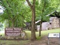 view gallery view galleryN29.5 km |  Big Buffalo Valley Historic District - Deer AR Big Buffalo Valley Historic District - Deer AR
in Wikipedia Entries The Big Buffalo Valley Historic District, also known as the Boxley Valley Historic District, is notable as a cultural landscape in Buffalo National River. It comprises the Boxley Valley in northern Arkansas, near the town of Ponca. posted by: Don.Morfe location: Arkansas date approved: 09/23/2021 last visited: 09/23/2021 |
 view gallery view galleryN29.5 km | Buffalo National River - Deer AR in Wikipedia Entries The Buffalo River, located in Northern Arkansas, was the first National River to be designated in the United States. The Buffalo River is 153 miles (246 km) long. posted by: Don.Morfe location: Maryland date approved: 09/23/2021 last visited: 09/23/2021 |
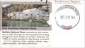 view gallery view galleryN29.5 km |  Buffalo National River - Deer AR Buffalo National River - Deer AR
in NPS Passport Cancellation Stations Buffalo National River cancellation stamp was posted on Oct 20, 1994. posted by: Don.Morfe location: Arkansas date approved: 02/20/2022 last visited: 02/11/2022 |
 view gallery view galleryN29.5 km |  Boxley Valley - Deer AR Boxley Valley - Deer AR
in Signs of History Marker is on State Route 43 in Deer Arkansas. posted by: Don.Morfe location: Arkansas date approved: 09/06/2023 last visited: 09/06/2023 |
 view gallery view galleryN29.5 km |  Buffalo National River - Deer AR Buffalo National River - Deer AR
in Satellite Imagery Oddities When establishing Buffalo National River in 1972, Congress recognized the need to preserve the valley’s culture as well as its free-flowing river. posted by: Don.Morfe location: Arkansas date approved: 02/10/2022 last visited: 02/11/2022 |
 view gallery view galleryS30.6 km | FG0993 L 30 1932 - Clarksville, AR in U.S. Benchmarks This U.S. Coast and Geodetic Survey Disk is on the northwest quadrant of the Courthouse Square in Clarksville, Arkansas. posted by: The Snowdog location: Arkansas date approved: 11/18/2020 last visited: never |
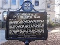 view gallery view galleryS30.6 km |  Clarksville in the Civil War / Depredations - Clarksville, AR Clarksville in the Civil War / Depredations - Clarksville, AR
in American Civil War Monuments and Memorials This double-sided Civil War Marker is on the right side of the sidewalk leading to the entrance to the Johnson County Courthouse; in Clarksville, Arkansas. posted by: The Snowdog location: Arkansas date approved: 12/01/2020 last visited: never |
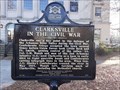 view gallery view galleryS30.6 km | Clarksville in the Civil War / Depredations - Clarksville, AR in U.S. Civil War Sites This double-sided Civil War Marker is on the right side of the sidewalk leading to the entrance to the Johnson County Courthouse; in Clarksville, Arkansas. posted by: The Snowdog location: Arkansas date approved: 11/30/2020 last visited: never |
 view gallery view galleryS30.6 km | Clarksville in the Civil War / Depredations - Clarksville, AR in Arkansas Historical Markers This double-sided Arkansas Historical Marker is on the right side of the sidewalk leading to the entrance to the Johnson County Courthouse; in Clarksville, Arkansas. posted by: The Snowdog location: Arkansas date approved: 11/30/2020 last visited: never |
 view gallery view galleryS30.6 km | Lone Pine School Bell - Clarksville, AR in Arkansas Historical Markers This marker gives a brief history of the Lone Pine school bell, which is on display on the County Courthouse lawn in Clarksville, Arkansas. posted by: The Snowdog location: Arkansas date approved: 11/19/2020 last visited: never |
 view gallery view galleryS30.6 km |  Lone Pine School Bell - Clarksville, AR Lone Pine School Bell - Clarksville, AR
in Bells The bell from the Lone Pine School is on display on the County Courthouse lawn in Clarksville, Arkansas. posted by: The Snowdog location: Arkansas date approved: 11/19/2020 last visited: never |
 view gallery view galleryS30.6 km | First Anthracite Coal - Clarksville, AR in Arkansas Historical Markers This historical marker is on the left side of the sidewalk leading to the entrance to the Johnson County Courthouse; in Clarksville, Arkansas. posted by: The Snowdog location: Arkansas date approved: 11/30/2020 last visited: never |
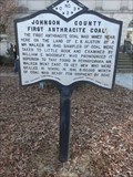 view gallery view galleryS30.6 km |  FIRST Anthracite Coal - Clarksville, AR FIRST Anthracite Coal - Clarksville, AR
in First of its Kind A historical marker at the Johnson County Courthouse describes the discovery of anthracite coal here; in Clarksville, Arkansas. posted by: The Snowdog location: Arkansas date approved: 11/30/2020 last visited: never |
|