 view gallery view gallery SW1.3 km SW1.3 km
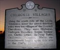
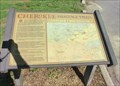
|   CHEROKEE VILLAGES ~ 1F 6 CHEROKEE VILLAGES ~ 1F 6
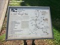
in Tennessee Historical Markers N35 35.494 W084 14.017 posted by:  Better Half Better Half location: Tennessee date approved: 11/01/2007 last visited: 01/16/2019 |
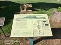
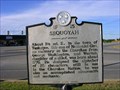 view gallery view gallerySW1.3 km | Sequoyah ~ 1F 15 in Tennessee Historical Markers Sequoyah ~ 1F 15 posted by: BackBrakeBilly location: Tennessee date approved: 09/20/2007 last visited: 01/16/2019 |
 view gallery view gallery S1.6 km S1.6 km
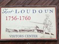
| FORT LOUDON ~ 1F 5 in Tennessee Historical Markers N35 35.109 W084 13.223 posted by: Better Half location: Tennessee date approved: 11/01/2007 last visited: 01/14/2019 |
 view gallery view gallery E1.8 km E1.8 km
|  "FORT LOUDOUN" Tennessee, USA "FORT LOUDOUN" Tennessee, USA
in Historic Forts First English fort west of the Appalachian / Great Smokey Mountains, Eastern USA. posted by:  Nevada Desert Rat Nevada Desert Rat location: Tennessee date approved: 06/09/2007 last visited: 01/14/2019 |
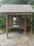
 view gallery view galleryE1.9 km |  Old British Sentinal Old British Sentinal
in Military Installations Fort Loudon - Founded in the early 1700's - this location was used as a fort in the fight against the indians. posted by: ThePesters4 location: Tennessee date approved: 03/03/2006 last visited: never |
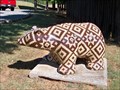 view gallery view galleryS2.3 km |  Sequoyah museum bear - Vonore, Tennessee Sequoyah museum bear - Vonore, Tennessee
in Bear Statues This beautiful bear was found outside the Sequoyah Museum in Vonore, TN. posted by: GT.US location: Tennessee date approved: 09/08/2010 last visited: never |
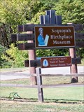 view gallery view galleryS2.3 km |  Sequoyah Birthplace Museum - Vonore, Tennessee Sequoyah Birthplace Museum - Vonore, Tennessee
in Trail of Tears The Sequoyah Birthplace museum is a stop on the Trail of Tears National Historic Trail. posted by: GT.US location: Tennessee date approved: 09/08/2010 last visited: never |
 view gallery view galleryS2.3 km |  The Tennessee Overhill Experience-From Furs to Factories - Vonore TN The Tennessee Overhill Experience-From Furs to Factories - Vonore TN
in Signs of History From the beginning of the eighteenth century until the American Revolution, Cherokee hunters and trappers traded tens of thousands of animal pelts for manufactured goods imported by licensed British traders. posted by: Don.Morfe location: Tennessee date approved: 10/29/2020 last visited: 09/24/2021 |
 view gallery view gallerySW2.3 km |  Family Fun Dog Wash ~ Etowah Tennessee Family Fun Dog Wash ~ Etowah Tennessee
in Self Serve Pet Wash Family Fun Dog Wash in Etowah Tennessee. posted by: BackBrakeBilly location: Tennessee date approved: 09/20/2007 last visited: 09/20/2007 |
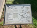
 view gallery view galleryS2.3 km | Cherokee Heritage Trails Tsalagi Usdi Nvnohi - Vonore TN in Signs of History Cherokee Heritage Trails (Tsalagi Usdi Nvnohi) wind through the mountains of North Carolina, Tennessee, and Georgia, in the heart of Cherokee homelands that once encompassed more than 140,000 square miles. posted by: Don.Morfe location: Tennessee date approved: 10/29/2020 last visited: 09/24/2021 |
 view gallery view galleryS2.3 km |  Cherokee Heritage Trails Tsalagi Usdi Nvnohi - Vonore TN Cherokee Heritage Trails Tsalagi Usdi Nvnohi - Vonore TN
in Wagon Roads and Trails Cherokee Heritage Trails (Tsalagi Usdi Nvnohi) wind through the mountains of North Carolina, Tennessee, and Georgia, in the heart of Cherokee homelands that once encompassed more than 140,000 square miles posted by: Don.Morfe location: Tennessee date approved: 10/29/2020 last visited: 09/24/2021 |
 view gallery view galleryS2.3 km | Unicoi Turnpike Trail A Path Through Time - Vonore TN in Signs of History The path now known as the Unicoi Turnpike Trail has existed for over 1,000 years. The earliest European maps of the area note the trail as a connector between Cherokee Territories and the coastal ports of Charleston and Savannah. posted by: Don.Morfe location: Tennessee date approved: 10/29/2020 last visited: 09/24/2021 |
 view gallery view galleryS2.3 km | Unicoi Turnpike Trail A Path Through Time - Vonore TN in Wagon Roads and Trails The path now known as the Unicoi Turnpike Trail has existed for over 1,000 years. The earliest European maps of the area note the trail as a connector between Cherokee Territories and the coastal ports of Charleston and Savannah. posted by: Don.Morfe location: Tennessee date approved: 10/29/2020 last visited: 09/24/2021 |
 view gallery view gallery NE2.9 km NE2.9 km
|  Morganton Branch - East Lakeshore National Recreation Trail - Greenback, TN, USA Morganton Branch - East Lakeshore National Recreation Trail - Greenback, TN, USA
in Scenic Hikes The posted coordinates take you to a large parking area with very clean restrooms (Wildcat Point). This is the South terminus of the East Lakeshore National Recreation Trail. posted by: Team Geologynut location: Tennessee date approved: 08/24/2015 last visited: 01/04/2019 |
 view gallery view galleryNE2.9 km |  Morganton Branch (South Trailhead) - East Lakeshore Trail - Greenback, TN Morganton Branch (South Trailhead) - East Lakeshore Trail - Greenback, TN
in Hiking and walking trailheads Morganton Branch Trailhead of the East Lakeshore Trail in Greenback, Tennessee. posted by: Team Geologynut location: Tennessee date approved: 07/03/2019 last visited: never |
 view gallery view galleryNE3.1 km | Wildcat Spur - East Lakeshore Trail System - Greenback, TN in Hiking and walking trailheads Where the Wildcat Spur branches off from the Morganton Branch. posted by: Team Geologynut location: Tennessee date approved: 07/03/2019 last visited: never |
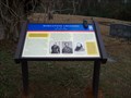
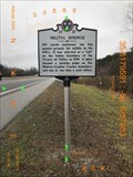 view gallery view galleryNE3.2 km | Militia Springs - 1F 17 - Greenback, TN in Tennessee Historical Markers Militia Springs historical marker located on US 411 in Greenback TN posted by: Team Geologynut location: Tennessee date approved: 01/17/2019 last visited: never |
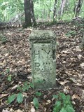
 view gallery view gallery N4.3 km N4.3 km
|  H.Y.R.W. Marker - Morganton Cemetery Rd / East Coast Tellico Pkwy - Greenback, TN H.Y.R.W. Marker - Morganton Cemetery Rd / East Coast Tellico Pkwy - Greenback, TN
in U.S. Historic Survey Stones and Monuments A concrete highway right-of-way marker located several feet off the highway in Greenback, TN. posted by: Team Geologynut location: Tennessee date approved: 05/31/2023 last visited: never |
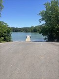 view gallery view galleryN4.5 km |  Morganton Boat Ramp - Greenback, Tennessee Morganton Boat Ramp - Greenback, Tennessee
in Boat Ramps A nice large public boat ramp in Greenback TN. posted by: Team Geologynut location: Tennessee date approved: 05/18/2023 last visited: never |
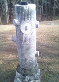 view gallery view galleryN4.8 km |  H. M. Milsaps - Morganton Cemetery - Greenback, TN H. M. Milsaps - Morganton Cemetery - Greenback, TN
in Woodmen of the World Grave Markers/Monuments WOW marker in Morganton Cemetery, Greenback Tennessee posted by: Team Geologynut location: Tennessee date approved: 01/20/2010 last visited: 01/28/2010 |
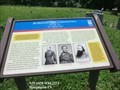
 view gallery view galleryN4.8 km |  Morganton Crossing *** Too Cold to Wade Morganton Crossing *** Too Cold to Wade
in Civil War Discovery Trail Sites Another one of our new "Civil War Trail" markers. This one's in Morganton Cemetery. The only thing remaining of the town of Moganton which was flooded by the damming of the Little Tennessee River. posted by: Team Geologynut location: Tennessee date approved: 01/27/2010 last visited: 06/03/2023 |
 view gallery view galleryN4.8 km | Morganton Crossing-Too Cold to Wade - Morganton TN in U.S. Civil War Sites Sherman discovered that the Morganton ford was 3 1/2 feet deep and 240 yards wide, making it impossible for the infantry to wade in the near freezing temperature. posted by: Don.Morfe location: Tennessee date approved: 06/03/2023 last visited: 06/03/2023 |
 view gallery view gallerySW4.8 km |  McDonald's -Hwy 411 - Vonore, TN USA McDonald's -Hwy 411 - Vonore, TN USA
in McDonald's Restaurants A McDonald's on Hwy 411 near the junction with Hwy 72 in Vonore, TN. posted by: Team Geologynut location: Tennessee date approved: 09/01/2015 last visited: 01/04/2019 |
 view gallery view galleryN5.5 km | H.Y.R.W. Marker - Morganton Branch Trail - Greenback, TN in U.S. Historic Survey Stones and Monuments A concrete highway right-of-way marker located several feet off the highway in Greenback, TN. posted by: Team Geologynut location: Tennessee date approved: 09/03/2020 last visited: never |
 view gallery view gallery NW6 km NW6 km
|  Clemmer Cemetery Clemmer Cemetery
in Worldwide Cemeteries Clemmer Cemetery located on Clemmer Road. posted by: Better Half location: Tennessee date approved: 05/17/2009 last visited: never |
|