 view gallery view gallery NE0.3 km NE0.3 km
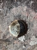
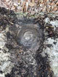
|   L 295 (FC1599) - Blount County, TN L 295 (FC1599) - Blount County, TN
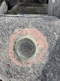
in U.S. Benchmarks A vertical control disk in a rock outcrop near Chilhowee Dam. posted by:  Team Geologynut Team Geologynut location: Tennessee date approved: 02/23/2023 last visited: never |
 view gallery view gallery SE1 km SE1 km
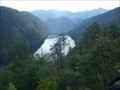
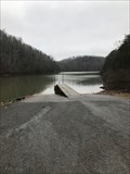
|  Chilhowee Dam Chilhowee Dam
in Water Dams The Chilhowee Dam is a hydroelectric development located in Blount and Monroe Counties, Tennessee. Photo and waypoint is from the overlook. posted by:  fatcat161 fatcat161 location: Tennessee date approved: 10/28/2008 last visited: 03/18/2013 |
 view gallery view gallery W3.4 km W3.4 km
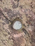
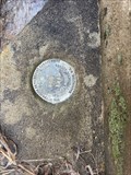
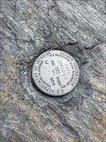
| J 295 (FC1601) - Blount County, TN in U.S. Benchmarks This NGS stainless steel rod is at a pull-off so parking is close. posted by: Team Geologynut location: Tennessee date approved: 02/23/2023 last visited: never |
 view gallery view galleryW3.9 km | H 295 (FC1602) - Blount County, TN in U.S. Benchmarks An easy to find vertical control disk in a small outcrop. Safe parking is about 350ft south of mark. DO NOT park on the road!! This is the road to The Dragon and there's alway motorcycles and exotic cars screaming down this road! posted by: Team Geologynut location: Tennessee date approved: 02/23/2023 last visited: never |
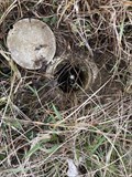
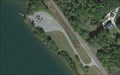 view gallery view galleryW3.9 km |  Harrison Branch Boat Ramp - Blount County, Tennessee Harrison Branch Boat Ramp - Blount County, Tennessee
in Boat Ramps Two lane ramp access for the Little Tennessee River. posted by: Team Geologynut location: Tennessee date approved: 06/21/2019 last visited: never |
 view gallery view gallery E4.7 km E4.7 km
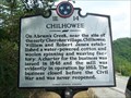
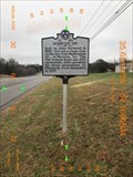
|  Chilhowee Chilhowee
in Tennessee Historical Markers Historical sign on Hwy 129 in Blount County, TN posted by: Team Geologynut location: Tennessee date approved: 07/16/2007 last visited: 08/04/2012 |
 view gallery view galleryE4.8 km | N 295 (FB2389) - Blount County, TN in U.S. Benchmarks An NGS vertical control mark easily found on a bridge abutment. posted by: Team Geologynut location: Tennessee date approved: 02/23/2023 last visited: never |
 view gallery view gallery NW4.8 km NW4.8 km
| G 295 (FC1603) - Blount County, TN in U.S. Benchmarks A vertical control disk set in the abutment of a small bridge. Very easy to find and close parking at the nearby church. posted by: Team Geologynut location: Tennessee date approved: 02/23/2023 last visited: never |
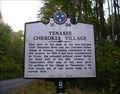 view gallery view galleryW5.1 km | TENASEE CHEROKEE VILLAGE ~ 1F 36 in Tennessee Historical Markers N35 31.964 W084 06.308 posted by: Better Half location: Tennessee date approved: 11/01/2007 last visited: 03/18/2013 |
 view gallery view galleryW5.1 km |  Tennessee ~ First known use of the State Name Tennessee ~ First known use of the State Name
in First of its Kind First known use of Tennessee's State name in the current form. N35 31.964 W084 06.308 posted by: Better Half location: Tennessee date approved: 11/01/2007 last visited: 03/18/2013 |
 view gallery view gallerySE6.6 km | N 11 (FB1779) Calderwood - Blount County, TN in U.S. Benchmarks A pretty tough to find benchmark disk in a boulder. Probably would not have found it without my pinpointer! The road to this benchmark closes at 3:00 PM daily! posted by: Team Geologynut location: Tennessee date approved: 02/23/2023 last visited: never |
 view gallery view galleryNW8.2 km | D 295 (FC1606) - Blount County, TN in U.S. Benchmarks A stainless steel rod in a large grassy triangle very close to a Tennessee Historical Marker. Safe parking at the nearby store. posted by: Team Geologynut location: Tennessee date approved: 02/23/2023 last visited: never |
 view gallery view gallerySE8.4 km |  Chilhowee Dam Chilhowee Dam
in Wikipedia Entries The Chilhowee Dam is a hydroelectric development located in Blount and Monroe Counties, Tennessee posted by: fatcat161 location: Tennessee date approved: 10/07/2008 last visited: 03/18/2013 |
 view gallery view gallery N12.1 km N12.1 km
|  Rock City Barn - RCB 42-05-02 Rock City Barn - RCB 42-05-02
in Barns See Rock City barn in Blount County, TN posted by: Wallyum location: Tennessee date approved: 04/11/2021 last visited: never |
 view gallery view gallerySE12.7 km | ET 50 WCE (FB2377) Tapoco - Blount County, TN in U.S. Benchmarks Very easy to find survey disk at a small pull-off on The Dragon. posted by: Team Geologynut location: Tennessee date approved: 02/23/2023 last visited: never |
 view gallery view galleryW13.2 km | Ball Play Boat Ramp - Monroe County, Tennessee in Boat Ramps Large boat ramp located off Hwy 360 in Monroe County, TN. posted by: Team Geologynut location: Tennessee date approved: 01/18/2019 last visited: never |
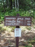 view gallery view galleryE14.2 km |  Gregory Bald Trail - Parson Branch Road end - Great Smoky Mountains National Park, TN Gregory Bald Trail - Parson Branch Road end - Great Smoky Mountains National Park, TN
in Hiking and walking trailheads Parson Branch Road trailhead of the Gregory Bald Trail posted by: hummerstation location: Tennessee date approved: 09/11/2012 last visited: never |
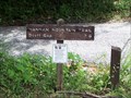 view gallery view galleryE14.2 km | Hannah Mountain Trail - Parson Branch Road end - Great Smoky Mountains National Park, TN in Hiking and walking trailheads Parson Branch Road trailhead of the Hannah Mountain Trail posted by: hummerstation location: Tennessee date approved: 09/11/2012 last visited: never |
 view gallery view gallerySE14.2 km |  Tail of the Dragon N35° 28.436 W83° 55.262 Tail of the Dragon N35° 28.436 W83° 55.262
in Web Cameras Webcam along Highway 129 posted by: Sakidoo location: Tennessee date approved: 03/29/2018 last visited: never |
 view gallery view gallerySE14.2 km |  Tennessee & North Carolina State Line Tennessee & North Carolina State Line
in Border Crossings Border crossing for Tennessee and North Carolina on Highway 129. This crossing is located in the Great Smokey Mountain National Park posted by: PersonsMD location: Tennessee date approved: 09/16/2009 last visited: 03/18/2013 |
 view gallery view galleryNW14.5 km | Norwood Inn - 1E 50 - Greenback, TN in Tennessee Historical Markers Norwood Inn historical marker located on US 411 in Greenback TN posted by: Team Geologynut location: Tennessee date approved: 01/17/2019 last visited: 06/13/2019 |
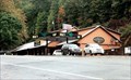
 view gallery view gallerySE14.8 km |  Tail of the Dragon - Deals Gap, North Carolina Tail of the Dragon - Deals Gap, North Carolina
in Roadside Attractions It’s the two-lane stretch of U.S. 129 to the north. Its 318 curves in 11 miles earned it the name Tail of the Dragon. posted by: YoSam. location: North Carolina date approved: 02/10/2019 last visited: 04/10/2014 |
 view gallery view gallerySE14.8 km | Deals Gap, North Carolina in Wikipedia Entries The Dragon two-lane stretch of U.S. 129 to the north. Its 318 curves in 11 miles earned it the name Tail of the Dragon. posted by: YoSam. location: North Carolina date approved: 02/11/2019 last visited: never |
 view gallery view gallerySE14.8 km |  The Dragon: Super-twisty N.C. Road is the Ultimate Fall Ride The Dragon: Super-twisty N.C. Road is the Ultimate Fall Ride
in News Article Locations It’s the two-lane stretch of U.S. 129 to the north. Its 318 curves in 11 miles earned it the name Tail of the Dragon. posted by: YoSam. location: North Carolina date approved: 02/10/2019 last visited: 03/27/2024 |
 view gallery view gallerySE14.8 km |  Deals Gap, North Carolina (Dragon's Tail) Deals Gap, North Carolina (Dragon's Tail)
in Elevation Signs Deals Gap, North Carolina Elevation 1756 Ft posted by: Rat Rat location: North Carolina date approved: 04/12/2011 last visited: 03/27/2024 |
|