 view gallery view gallery SW0.5 km SW0.5 km
|   N 35º 32.178 W 87º 12.353 - Mt. Pleasant, TN N 35º 32.178 W 87º 12.353 - Mt. Pleasant, TN
in Coordinate Palindromes A coordinate palindrome is located in front of a pizza restaurant in Mt. Pleasant posted by:  Max and 99 Max and 99 location: Tennessee date approved: 12/02/2019 last visited: never |
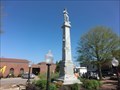 view gallery view gallerySW0.8 km |  Mount Pleasant Confederate Memorial - Mount Pleasant TN Mount Pleasant Confederate Memorial - Mount Pleasant TN
in U.S. Civil War Sites Erected in memory of our Confederate soldiers by the Bigby Gray Chapter, U.D.C. The love, gratitude and memory of the people of the South shall gild their fame in one eternal sunshine. posted by:  Don.Morfe Don.Morfe location: Tennessee date approved: 07/02/2023 last visited: 07/02/2023 |
 view gallery view gallerySW0.8 km | The Bigby Greys-Story of Service - Mount Pleasant TN in U.S. Civil War Sites Here on the square, on April 20, 1861, a hundred local men under Capt. Daniel F. Wade were sworn into Confederate service as the Bigby Greys. posted by: Don.Morfe location: Tennessee date approved: 06/03/2023 last visited: 06/03/2023 |
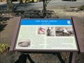 view gallery view gallerySW0.8 km | The Bigby Greys-Story of Service - Mount Pleasant TN in Civil War Discovery Trail Sites Here on the square, on April 20, 1861, a hundred local men under Capt. Daniel F. Wade were sworn into Confederate service as the Bigby Greys. posted by: Don.Morfe location: Tennessee date approved: 06/18/2020 last visited: 10/05/2021 |
 view gallery view gallery NE2.6 km NE2.6 km
|  Maury County Airport - Mt. Pleasant, TN - 672 feet Maury County Airport - Mt. Pleasant, TN - 672 feet
in Elevation Signs Maury County Airport - Mt. Pleasant, TN - 672 feet posted by: CuriousBM location: Tennessee date approved: 10/22/2016 last visited: 05/21/2018 |
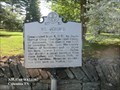
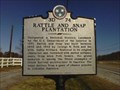 view gallery view galleryNE5.1 km |  Rattle and Snap Plantation - 3D 74 - Maury County, TN Rattle and Snap Plantation - 3D 74 - Maury County, TN
in Tennessee Historical Markers Marker for a historic plantation. posted by: bmon419 location: Tennessee date approved: 11/12/2011 last visited: 01/25/2023 |
 view gallery view galleryNE6.9 km |  Delaying Forrest "...a decided stand" - Columbia TN Delaying Forrest "...a decided stand" - Columbia TN
in Battlefields On November 23, 1864 Capron's command stood and rallied while converging swarms of Confederate cavalrymen attacked and almost overwhelmed them. Capron's delaying action prevented the immediate Confederate capture of Columbia. posted by: Don.Morfe location: Tennessee date approved: 05/12/2023 last visited: 05/12/2023 |
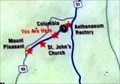
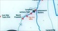 view gallery view galleryNE6.9 km |  You Are Here Maps-Delaying Forrest "...a decided stand" - Columbia TN You Are Here Maps-Delaying Forrest "...a decided stand" - Columbia TN
in 'You Are Here' Maps The You Are Here Map shows that you are at St. Johns Church and Cemetery, Trotwood Avenue (State Highway 243), Columbia TN posted by: Don.Morfe location: Tennessee date approved: 05/11/2023 last visited: 05/12/2023 |
 view gallery view galleryNE6.9 km | Delaying Forrest "...a decided stand" - Columbia TN in U.S. Civil War Sites On November 23, 1864 Capron's command stood and rallied while converging swarms of Confederate cavalrymen attacked and almost overwhelmed them. Capron's delaying action prevented the immediate Confederate capture of Columbia. posted by: Don.Morfe location: Tennessee date approved: 05/12/2023 last visited: 05/12/2023 |
 view gallery view galleryNE6.9 km | Delaying Forrest "...a decided stand" - Columbia TN in Civil War Discovery Trail Sites Suddenly, the Union horsemen encountered the advance elements of Confederate Gen. Nathan Bedford Forrest's cavalry, riding ahead of the main army, near Henryville. posted by: Don.Morfe location: Tennessee date approved: 05/18/2020 last visited: 10/06/2021 |
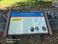
 view gallery view galleryNE6.9 km | St. John's (3D 37) - Columbia TN in Tennessee Historical Markers Consecrated Sept. 4, 1842, by James Hervey Otey, first Episcopal Bishop of Tennessee, this church was built by Leonidas Polk, then Missionary Bishop of Southwest and his three brothers, George, Lucius, and Rufus. posted by: Don.Morfe location: Tennessee date approved: 10/13/2020 last visited: 10/20/2021 |
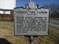 view gallery view galleryNE7.4 km | Forrest and Capron - 3D 19 - Maury County, TN in Tennessee Historical Markers Marker noting the location of part of the Battle of Columbia of the Civil War. posted by: bmon419 location: Tennessee date approved: 11/12/2011 last visited: 05/12/2023 |
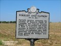 view gallery view galleryNE7.4 km | Forrest and Capron - Columbia TN in Battlefields Forrest’s cavalry, screening the advance of Stewart’s Corps on Columbia met Capron’s Cavalry Brigade in this locality and chased it back to Columbia. posted by: Don.Morfe location: Tennessee date approved: 05/12/2023 last visited: 05/12/2023 |
 view gallery view galleryNE7.4 km | Forrest and Capron Nov. 24,1864 - Columbia TN in American Civil War Monuments and Memorials The marker is located on Trotwood Ave, Columbia TN posted by: Don.Morfe location: Tennessee date approved: 09/30/2023 last visited: 09/30/2023 |
 view gallery view gallery NW7.6 km NW7.6 km
|  Forgotten cemetery brought back to life - Hampshire, TN Forgotten cemetery brought back to life - Hampshire, TN
in News Article Locations Pisgah Cemetery in on Pisgah Ridge Rd. between Mt. Pleasant and US Highway 412. posted by: Max and 99 location: Tennessee date approved: 12/02/2019 last visited: never |
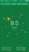
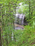 view gallery view gallerySW10.3 km |  Stillhouse Hollow Falls Stillhouse Hollow Falls
in Waterfalls A beautiful water fall, the tallest we have found in this part of Tennessee. The trail also leads from the top of falls to the bottom. posted by: wtschume location: Tennessee date approved: 07/03/2011 last visited: never |
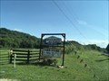 view gallery view galleryNW11.3 km |  Highland Berries and Produce - Hampshire, TN Highland Berries and Produce - Hampshire, TN
in Berry Picking Great stop for fresh berries posted by: tnwave location: Tennessee date approved: 07/07/2019 last visited: 07/09/2019 |
 view gallery view galleryNW11.3 km |  Highland Berries and Produce - Hampshire, TN Highland Berries and Produce - Hampshire, TN
in Pick-Your-Own Farms A wonderful little fresh produce stand where you can pick what’s ripe or buy what’s already picked. posted by: tnwave location: Tennessee date approved: 07/09/2019 last visited: 07/10/2019 |
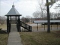 view gallery view galleryNE13 km |  SUDBERRY-MIDSOUTH LIVE STEAMERS-MAURY COUNTY PARK, COLUMBIA, TN SUDBERRY-MIDSOUTH LIVE STEAMERS-MAURY COUNTY PARK, COLUMBIA, TN
in Miniature Railroads MINIATURE RAILROAD TRACKS IN COLUMBIA, TN posted by: dillonsdaddy location: Tennessee date approved: 01/26/2009 last visited: 07/01/2019 |
 view gallery view galleryNE13.2 km | Road to Nashville-Columbia Artillery Duel - Columbia TN in U.S. Civil War Sites On November 26, 1864, Lee’s infantrymen formed a long skirmish line extending about a mile to your right and a mile to your left. At the same time, he opened fire on the Union fortifications with part of his artillery here. posted by: Don.Morfe location: Tennessee date approved: 05/12/2023 last visited: 05/12/2023 |
 view gallery view galleryNE13.2 km | Road to Nashville-Columbia Artillery Duel - Columbia TN in Battlefields On November 26, 1864, Lee’s infantrymen formed a long skirmish line extending about a mile to your right and a mile to your left. At the same time, he opened fire on the Union fortifications with part of his artillery here. posted by: Don.Morfe location: Tennessee date approved: 05/12/2023 last visited: 05/12/2023 |
 view gallery view galleryNE13.2 km | You Are Here Maps-Road to Nashville-Columbia Artillery Duel - Columbia TN in 'You Are Here' Maps The You Are Here Map shows that you are at the Maury County Shopping Center, 1412 Trotwood Avenue, Columbia TN. posted by: Don.Morfe location: Tennessee date approved: 05/11/2023 last visited: 05/12/2023 |
 view gallery view galleryNE13.2 km | Road to Nashville-Columbia Artillery Duel - Columbia TN in Civil War Discovery Trail Sites On November 26, 1864, as Confederate Gen. John Bell Hood’s army approached Columbia, he sent Gen. Stephen D. Lee’s corps to “demonstrate heavily” (feign an attack) against the Federal defenses on the south side of the town. posted by: Don.Morfe location: Tennessee date approved: 05/18/2020 last visited: 10/06/2021 |
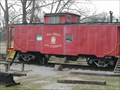 view gallery view galleryNE13.4 km |  RED CABOOSE--MAURY COUNTY PARK, COLUMBIA, TN RED CABOOSE--MAURY COUNTY PARK, COLUMBIA, TN
in Train Cabooses RED CABOOSE IN MAURY COUNTY PARK USED BY MID-SOUTH LIVE STEAMERS posted by: dillonsdaddy location: Tennessee date approved: 01/26/2009 last visited: 09/03/2011 |
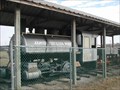 view gallery view galleryNE13.4 km |  ARMOUR FERTILIZER WORKS #9--COLUMBIA, TN ARMOUR FERTILIZER WORKS #9--COLUMBIA, TN
in Locomotives permanent display of steam engine posted by: dillonsdaddy location: Tennessee date approved: 01/26/2009 last visited: 09/03/2011 |
|