 view gallery view gallery 0 km 0 km
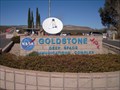
|   Goldstone Deep Space Communications Complex - Mojave Desert, CA Goldstone Deep Space Communications Complex - Mojave Desert, CA
in Wikipedia Entries The Goldstone Deep Space Communications Complex uses satellites to see what is in our galaxy. posted by:  Gryffindor3 Gryffindor3 location: California date approved: 12/08/2009 last visited: never |
 view gallery view gallery SE5.1 km SE5.1 km
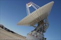
|  Pioneer Deep Space Station - Fort Irwin, CA Pioneer Deep Space Station - Fort Irwin, CA
in U.S. National Register of Historic Places The Pioneer Antenna is the first of over 10 antenna at Goldstone which track the Mars Rovers, Hubble, Voyager, and over 30 other satellites in deep space. Access & free tours for the public can be arranged through their website. posted by:  DopeyDuck DopeyDuck location: California date approved: 02/03/2009 last visited: 01/31/2009 |
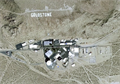
 view gallery view gallerySE15.8 km |  Goldstone from Above - Fort Irwin, CA Goldstone from Above - Fort Irwin, CA
in Readable From Above I wonder if the astronauts can see the letters on the hill behind NASA's Goldstone Deep Space Network complex? I bet Hubble or Voyager could. posted by: DopeyDuck location: California date approved: 09/05/2009 last visited: 04/08/2011 |
 view gallery view gallerySE15.8 km |  GOLDSTONE Letters on Hill - Fort Irwin, CA GOLDSTONE Letters on Hill - Fort Irwin, CA
in Letters on Hills It's pretty obvious when you're getting close to NASA's Goldstone Deep Space Network when you see these large letters . posted by: DopeyDuck location: California date approved: 02/02/2009 last visited: 04/08/2011 |
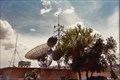 view gallery view gallerySE15.9 km |  Echo Station, NASA Goldstone facility, Ft. Irwin, CA Echo Station, NASA Goldstone facility, Ft. Irwin, CA
in Weather Stations A weather station at Echo Station, the administrative headquarters of NASA's Goldstone deep-space tracking station. posted by: LeoGeo location: California date approved: 04/11/2011 last visited: never |
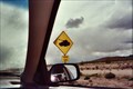 view gallery view gallerySE27 km |  Tank Crossing - Ft. Irwin, California Tank Crossing - Ft. Irwin, California
in Uncommon Crossing Signs One of several "Tank Crossing" signs in the huge Fort Irwin training base in California. posted by: LeoGeo location: California date approved: 04/20/2011 last visited: 04/18/2019 |
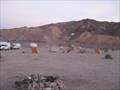
 view gallery view gallerySE27.8 km |  Fort Irwin's Finest - Fort Irwin, CA Fort Irwin's Finest - Fort Irwin, CA
in Best Kept Secrets This location is truly a rare and unexpected sight. Everyone in our group marveled at what was here. Plan on spending some time looking around in both awe at the site as well as all the sacrifices of Fort Irwin's finest. posted by: DopeyDuck location: California date approved: 02/05/2009 last visited: 01/31/2009 |
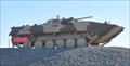
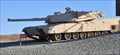 view gallery view gallery S32.2 km S32.2 km
|  M1 Abrams Main Battle Tank ~ Fort Irwin, California M1 Abrams Main Battle Tank ~ Fort Irwin, California
in Military Ground Equipment Displays This Military Ground Equipment Display is located at the main entrance to the Fort Irwin National Training Command in the Mohave Desert northeast of Barstow, California. posted by: brwhiz location: California date approved: 07/23/2013 last visited: never |
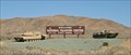 view gallery view galleryS32.2 km |  The National Training Center - Fort Irwin, CA The National Training Center - Fort Irwin, CA
in Military Installations Fort Irwin/The National Training Center is a major training area for the US Military. posted by: DopeyDuck location: California date approved: 02/02/2009 last visited: 05/24/2016 |
 view gallery view galleryS32.2 km | Soviet BMP-1 Tank in Military Ground Equipment Displays This Military Ground Equipment Display is located at the main entrance to the Fort Irwin National Training Command in the Mohave Desert northeast of Barstow, California. posted by: brwhiz location: California date approved: 07/23/2013 last visited: 07/24/2013 |
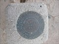
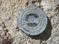 view gallery view gallerySE34.3 km |  FT1511 - Tiefort Mountain - San Bernadino County, CA FT1511 - Tiefort Mountain - San Bernadino County, CA
in U.S. Benchmarks Triangulation Station disk on top of Tiefort Mountain in the Mojave Desert. posted by: TheRadcliffs location: California date approved: 07/03/2014 last visited: 12/01/2016 |
 view gallery view gallery SW37.5 km SW37.5 km
|  Inscription Canyon Petroglyphs Inscription Canyon Petroglyphs
in Pictographs A small lava valley with many petroglyphs. posted by: Rumpled location: California date approved: 01/07/2008 last visited: never |
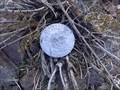 view gallery view galleryS41.4 km | LADWP L72F E114 Survey Point in U.S. Benchmarks A LADWP Survey Point posted by: Rumpled location: California date approved: 01/08/2008 last visited: never |
 view gallery view galleryS42.2 km |  Strategic Bomber XB-70A 'Valkyrie' - Barstow, CA Strategic Bomber XB-70A 'Valkyrie' - Barstow, CA
in Plane Crash Sites 6-8-1966, Al White & Maj. Carl S. Cross took AV-2 up to make 12 subsonic airspeed calibration runs and one supersonic test. The XB-70 was scheduled to rendezvous with a contingent of jet aircraft. The crash occured then with air collision. posted by: calgriz location: California date approved: 04/23/2014 last visited: 10/24/2013 |
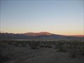 view gallery view gallery NE42.3 km NE42.3 km
|  Hollow Hills Wilderness Area - BLM - CA Hollow Hills Wilderness Area - BLM - CA
in Public Access Lands A large wilderness provices ample recreational opportunities. posted by: ChapterhouseInc location: California date approved: 01/27/2011 last visited: 01/18/2011 |
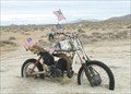 view gallery view gallerySW42.5 km |  Jim Erickson's Husky Memorial near Cuddeback Dry Lake Jim Erickson's Husky Memorial near Cuddeback Dry Lake
in Out of Place Graves A memorial out in the desert that started out just for Jim. Now he is joined by many others that loved desert riding as Jim did that have since passed on. posted by: Moag Ohana location: California date approved: 09/25/2008 last visited: never |
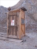 view gallery view galleryNE47.2 km |  Cabin Outhouse - Hollow Hills, CA Cabin Outhouse - Hollow Hills, CA
in Outhouses A functional outhouse serves a remote cabin on BLM property. posted by: ChapterhouseInc location: California date approved: 01/26/2011 last visited: 01/19/2011 |
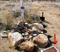
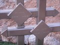 view gallery view galleryNE47.3 km |  Cabin Cemetery Headstones - CA Cabin Cemetery Headstones - CA
in Homemade Tombstones A pair of graves lies next to the two friends 'hunting' cabin in the desert. posted by: ChapterhouseInc location: California date approved: 01/27/2011 last visited: 01/19/2011 |
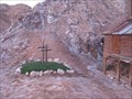 view gallery view galleryNE47.3 km |  Cabin Cemetery - CA Cabin Cemetery - CA
in Worldwide Cemeteries A pair of graves lies next to the two friends 'hunting' cabin in the desert. posted by: ChapterhouseInc location: California date approved: 01/27/2011 last visited: 01/19/2011 |
 view gallery view galleryNE47.3 km | Cabin Cemetery - CA in Out of Place Graves A pair of graves lies next to the two friends 'hunting' cabin in the desert. posted by: ChapterhouseInc location: California date approved: 01/26/2011 last visited: 01/19/2011 |
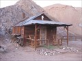 view gallery view galleryNE47.3 km | Hollow Hills Cabin - CA in Best Kept Secrets Located in the BLM Hollow Hills Wilderness Area, this cabin has been a recreational hideaway to many people since 1927. posted by: ChapterhouseInc location: California date approved: 02/09/2011 last visited: 01/18/2011 |
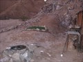
 view gallery view galleryNE47.3 km |  Cabin Campsite - Hollow Hills, CA Cabin Campsite - Hollow Hills, CA
in Free Campsites Located in the Hollow Hills Recreation Area, a cabin sits at a longtime camping area. posted by: ChapterhouseInc location: California date approved: 01/27/2011 last visited: 01/19/2011 |
 view gallery view galleryNE47.6 km | FT0152 - P684 in U.S. Benchmarks Located in Death Valley National Park along a dirt road. posted by: ChapterhouseInc location: California date approved: 01/30/2011 last visited: 01/19/2011 |
 view gallery view gallery NW48.3 km NW48.3 km
|  Trona Pinnacles, 'Star Trek 5: The Final Frontier', Various films & TV shows- Ridgecrest California Trona Pinnacles, 'Star Trek 5: The Final Frontier', Various films & TV shows- Ridgecrest California
in Movie Locations Trona Pinnacles Recreation Lands, an area in the Searles Dry Lake Bed in Trona, San Bernardino County, central California was used as planetary place, 'Sha Ka Ree'. It was also used in various films and TV shows. posted by: calgriz location: California date approved: 05/14/2014 last visited: 01/14/2014 |
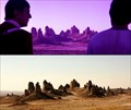 view gallery view galleryNW48.3 km |  'Star Trek 5: The Final Frontier'- 'Trona Pinnacles- Ridgecrest California 'Star Trek 5: The Final Frontier'- 'Trona Pinnacles- Ridgecrest California
in Star Trek Star Trek V: The Final Frontier filming location: ‘Nimbus III in the Neutral Zone, the Planet of Galactic Peace’- Owens Dry Lake in the Mojave Desert, north of Mojave, California near Ridgecrest CA between Routes 395 and 136. posted by: calgriz location: California date approved: 06/29/2014 last visited: 12/30/2014 |
|